Introduction
We’ve begun using the term “Fourth Runway” to describe two large projects (the Sustainable Airport Master Plan and SR-509) as one system.
The two projects have always been part of a regional plan begun over fifty years ago to meet the strategic goals of the Port Of Seattle and what is now the Puget Sound Regional Council (PSRC). One must consider them as a single system because when they are both completed (target 2027) they will have exactly the same community impacts (noise, pollution, socio-economic) as the addition of the Third Runway in 2008.
We fully understand that using such a provocative term may strike some as alarmist. But given the dramatic changes that each major expansion of the airport have caused for the communities, we think it worth the risk. Someone should be raising the alarm.
Obviously, there is no physical fourth runway at Sea-Tac Airport, nor can there ever be due to the lack of available land. And yes, they are being implemented by two independent agencies (the Port of Seattle and WSDOT.) However, we chose the term carefully and intentionally. Calling the two projects “The Fourth Runway” allows us to make three things clear:
- The two projects are not separate. They were planned together from the ground up. And in fact, the SAMP is not possible without SR-509. The fact that they will both be completed at the same time is no coincidence.
- The initial impacts to residents will be felt near the new freeway. Regardless of walking trails and other amenities, these will be noise and pollution impacts similar to those along the current 3north freeway access to the airport.
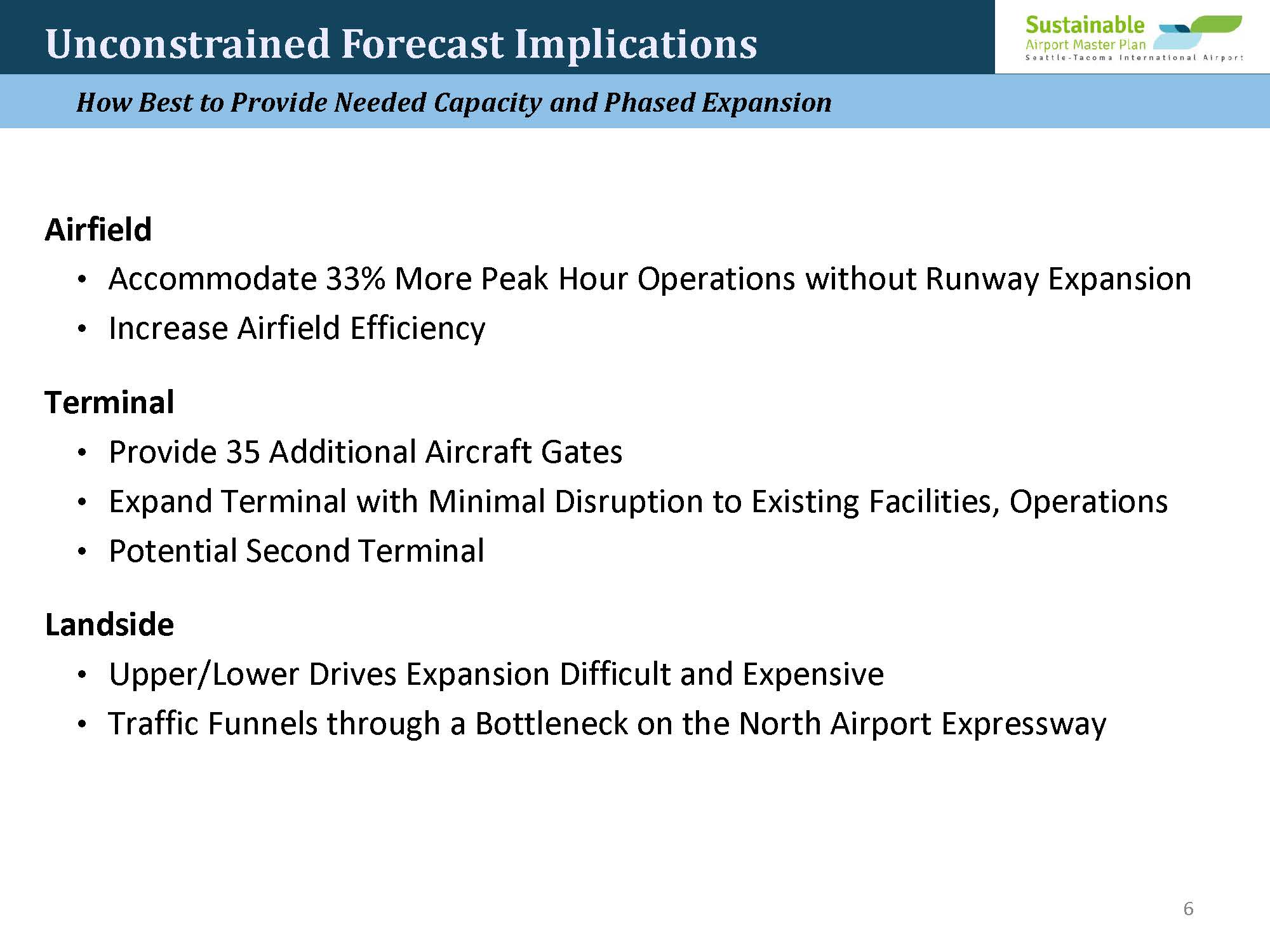
- But far more significant will be the community impacts from the increased air traffic SR-509 enables. Daily operations are expected to increase by 33%, which would easily surpass the increases afforded by building a (physical) Third Runway in 2008.
How is it possible to add so many more daily operations without building a physical runway? This document will attempt to explain the process in layman’s terms. And to do that, let’s start with a bit of history…
The Port’s Highway
Nothing about SR-509 is simple. We have numerous nits to pick with this Wikipedia entry. But one thing the article gets right is that SR-509 has gone through more changes than a Las Vegas showgirl. 😀 But regardless of era or proposed route, SR-509 has always seemed to be working on two directions simultaneously, a south end and a north end. Just so, construction on the final phase (Completion Project Stage 2) is occurring on two fronts at once. So when you ask planners about ‘Stage 2’, you must specify which end of the snake to which you’re referring. It is so overly-complicated it must bee seen as either indifferent to public understanding or intentionally misleading.
What the airport communities think of now as SR-509 was conceived of as early as the Second Runway construction in the late 1960’s. (Back then it was called the Burien Freeway.) Regardless, it was the express will of regional planners to provide the Port of Seattle with highway speed access from the docks onto Sea-Tac Airport and then onto I-5.
It’s good to have options
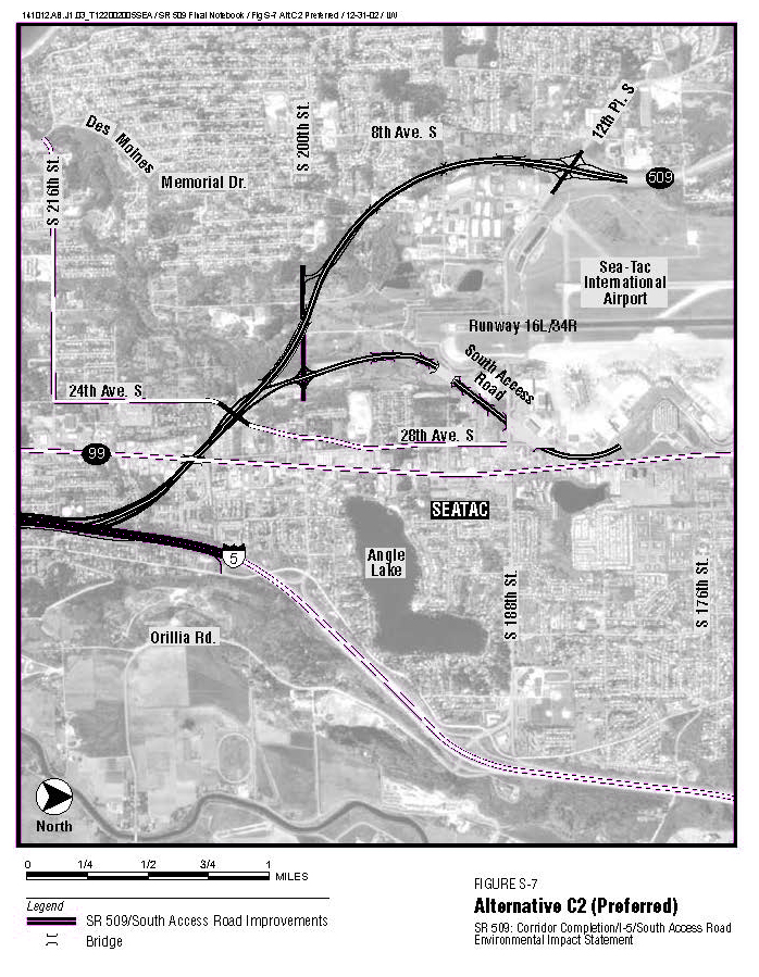
If you look at an aerial map of Des Moines, you’ll see that the current SR-509 past the airport is actually 1st Ave South from 188th down to Marine View Drive and onto Saltwater State Park. That was the ‘original’ route. But you’ll also notice two large swaths of forest which seem to emerge from the backside of the airport, one heading southwest towards Marine View Drive and the Beach Park and one heading due south towards what is now 15th Ave (in red). Those are not there because King County had such environmentally woke planners back in the day. Those are all areas WSDOT bought in advance. So at various times there have been three possible routes for SR-509. (When you have those kinds of resources you have options.)
The final alignment (yellow line) was chosen in 2015 partly to provide some shared efficiencies with the Link Light Rail and partly because the Kent Valley was now such big business. So, access to SR-167 via Veterans Memorial Drive are also now part of the plan.
Cleanup On Aisle 15th
And now that all phases are underway, the dozens of various bits of surplus land are being sold off, mostly unnoticed, although not always unnoticed. For this article, we’re focusing on the areas nearest the airport property which directly affect airport operations.
Two Approaches
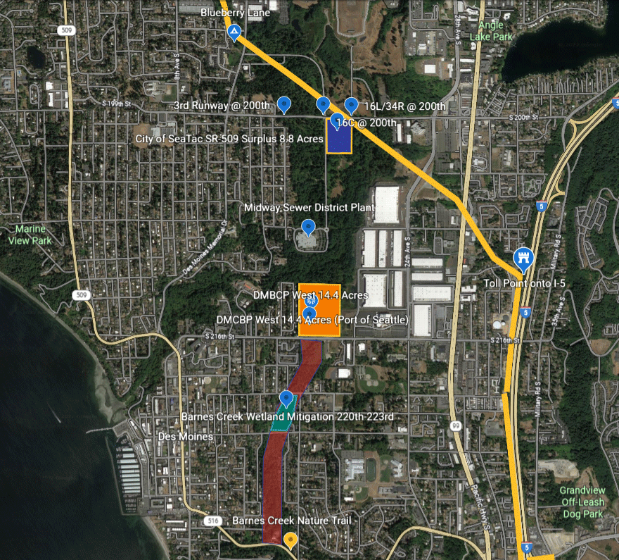
In 2017, WSDOT announced its intention to auction off two segments of that central strip\ running along where 15th Ave. That means 8.8 acres on the north end at 200th Street west of the Des Moines Creek Trail (blue), and 14.4 acres at the south end on 216th Street in Des Moines (orange). Sales of both parcels concluded in 2021. This gives us one clear example of how important it is to factor local politics into the discussion.
- In 2021, the City of SeaTac purchased the north parcel (blue) with help from King County grants, and started converting their side (blue) as an extension of the DMCT; healthy forest, bike trails and park land.
- In 2021, the City of Des Moines gave the southern parcel (orange) to the Port of Seattle for purchase. And on Jul 12th 2022, the Port gave Panattoni Partners the right to develop it as Des Moines Creek Business Park West, the same developers of Phases I, II and III.
Each city around the airport has its own set of values, especially when it comes to the environment. And these can be almost as important to protecting the community as any action taken by either WSDOT or the Port of Seattle.
Other Mitigations
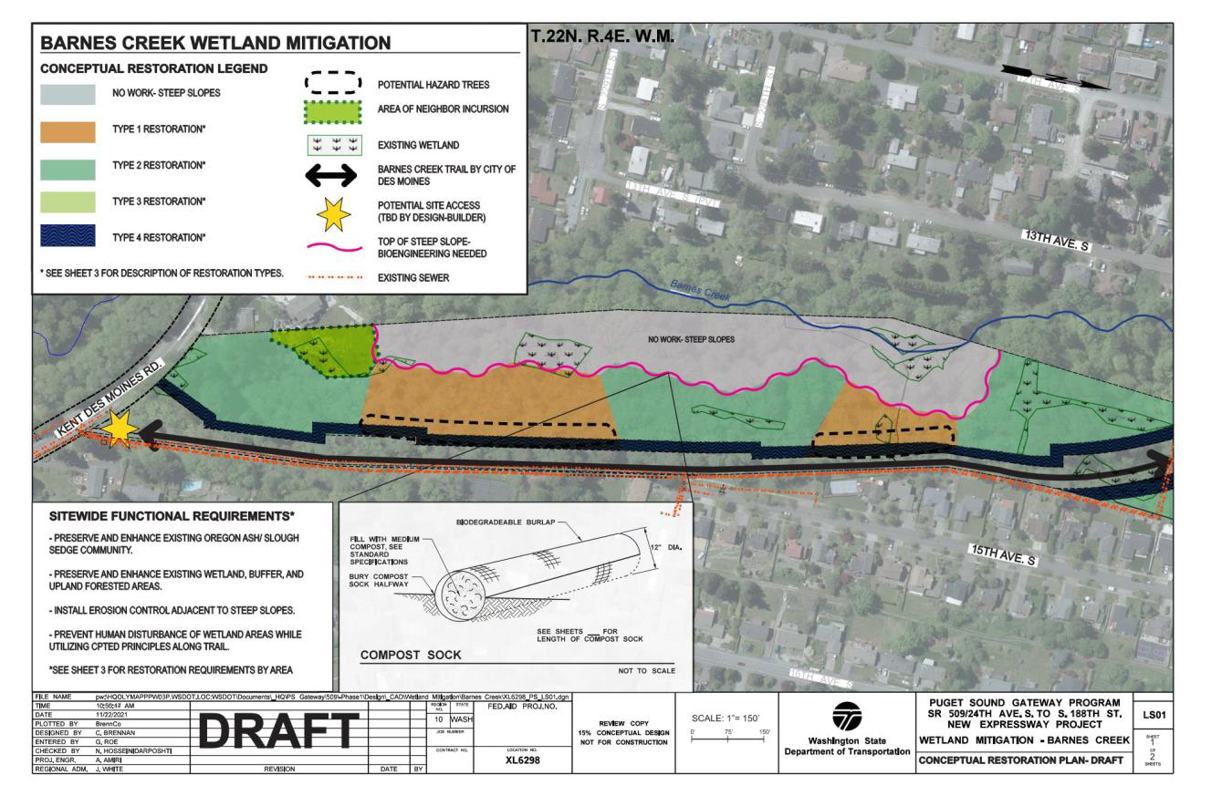
The main public amenity for residents near Stage 2 and the airport will be the Lake To Sound Trail. That isn’t really a ‘mitigation’ because, strictly speaking, it will have no positive impact on the environment or climate change. Other than some minor tree replacements, all true environmental mitigations will occur far away from 200th and the southern access to the airport. These will include sound walls, some tree replacements along the Light Rail and 30th Ave, a walking trail from Kent Des Moines Road and 15th up 223rd and then a wetlands reclamation to 220th connecting with Barnes Creek Trail.
Far from neutral
However, the tree loss is currently estimated to be north of 18,000, which swamps any of the above benefits in terms of C02 emissions. Regardless of any other impacts and mitigations, just building SR-509 without concern for carbon neutrality, we’ve done that bit more to speed global warming.
First modal impact (Road)
There will be two major impacts to the communities of SeaTac and Des Moines, which correspond with two modes of transportation: road and air.
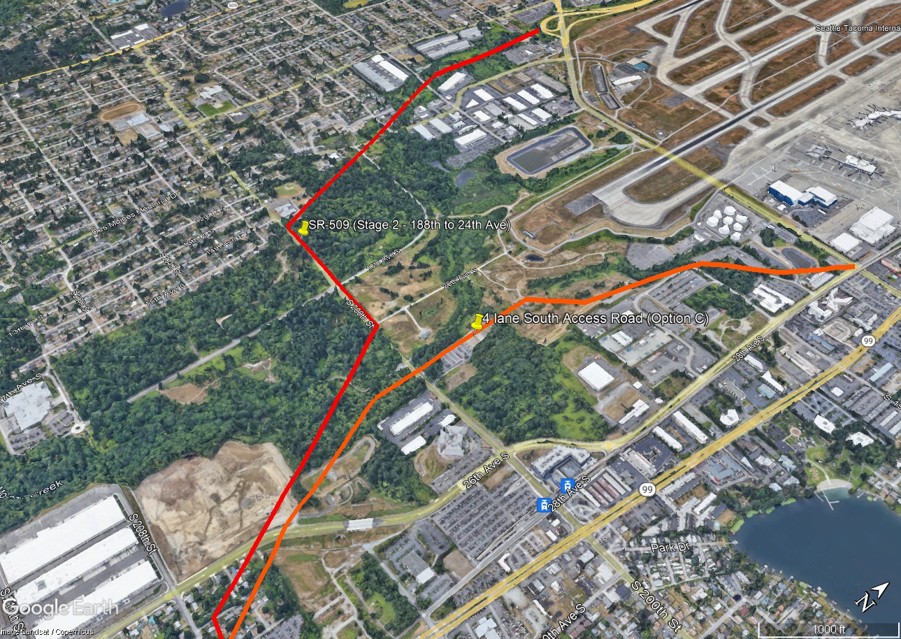
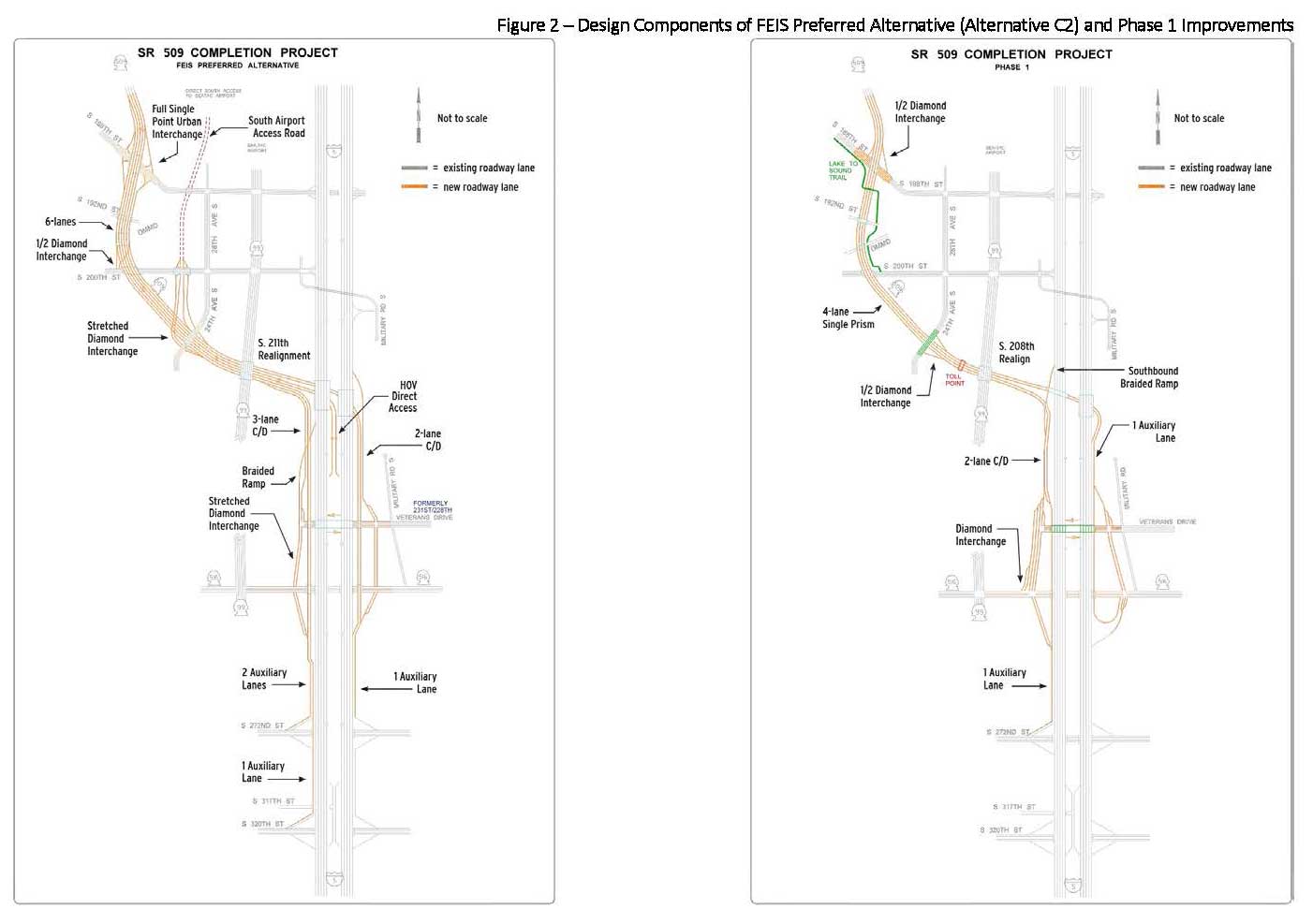
At some point, SR-509 highway will provide a southern entrance/exit to the airport according to current planning (SR 509 Corridor Completion/I-5/South Access Road EIS). The location will be a four lane Southern Access Road starting on airport property off of 28th Ave. It would connect to SR-509 at the underpass along 24th Ave. This entrance was intended to be completed as part of Phase II, but it was put on hold in 2020 due to lack of funding. Its likely implementation is now in the early 2030’s. It will be optimized for truck traffic.
And from our perspective, this is the main reason SR-509 was built. Anything else is just gravy. Having the ability for cargo to exit the airport at freeway speed, bypassing all the surface streets, and zip directly onto I-5, SR-167 and the Kent Valley is huge.
So, any living spaces along the path, from 188th and Des Moines Memorial Drive and south and east along 200th east to 24th Avenue (near the Federal Detention Center) will be effectively living next to a freeway. And the vehicle noise and emissions will be predominantly from trucks. (Think the Tukwila Interurban nexus with I-5. Noise levels there can be greater than homes under the flight paths depending on traffic and time of day.) Along Stage 2, the Blueberry Lane neighborhood of Des Moines and residences along 200th will be 4particularly hard hit.
Now that’s generosity
And as a double bonus, there are tolls. Not only are your state taxes paying for construction of SR-509, your user fees will pay for the road’s ongoing upkeep, although the primary beneficiary will always be the Port of Seattle, airlines and shippers. The generosity of WA drivers is amazing.
Second modal impact (Air)
We’re (finally!) getting to the marquee item in this article: the increase in daily flights that SR-509 helps enable. But this also requires a bit of a setup, because an airport actually consists of three major component systems: Air, Ground (the airport property), and then surrounding access roads (like SR-518 now and SR-509 in 2027.)
NextGen (the air)
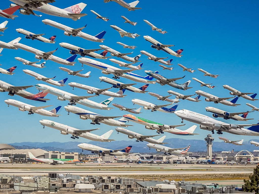
Until about 2008 there was a built-in limitation to daily operations: radar. For decades, what made life next to the airport tolerable was the fact that radar-based navigation is not all that precise. FAA rules required spacing take offs and landings several minutes apart and almost never allowed planes to land or take off on more than one runway at any given moment.
Starting around 2008, the industry began rolling out a series of much more accurate technologies to replace it referred to collectively as NextGen. Since then, ODthe biggest impediment to airport expansion has been on the ground, not in the air.
NextGen now allows airplanes to be spaced much closer on all three planes. (Think 40 seconds apart, not 4 minutes apart front to back.) It is also becoming practical to run parallel landings and take-offs, practices that were either uncommon or forbidden until recently. Residents have already witnessed these increases. But the tighter spacing we’re now experiencing is nowhere near the practical limit. NextGen can (in theory) process more than twice as many daily operations, simply by spacing aircraft closer together.
But to do that, you also have process the planes, passengers and cargo on the ground twice as fast.
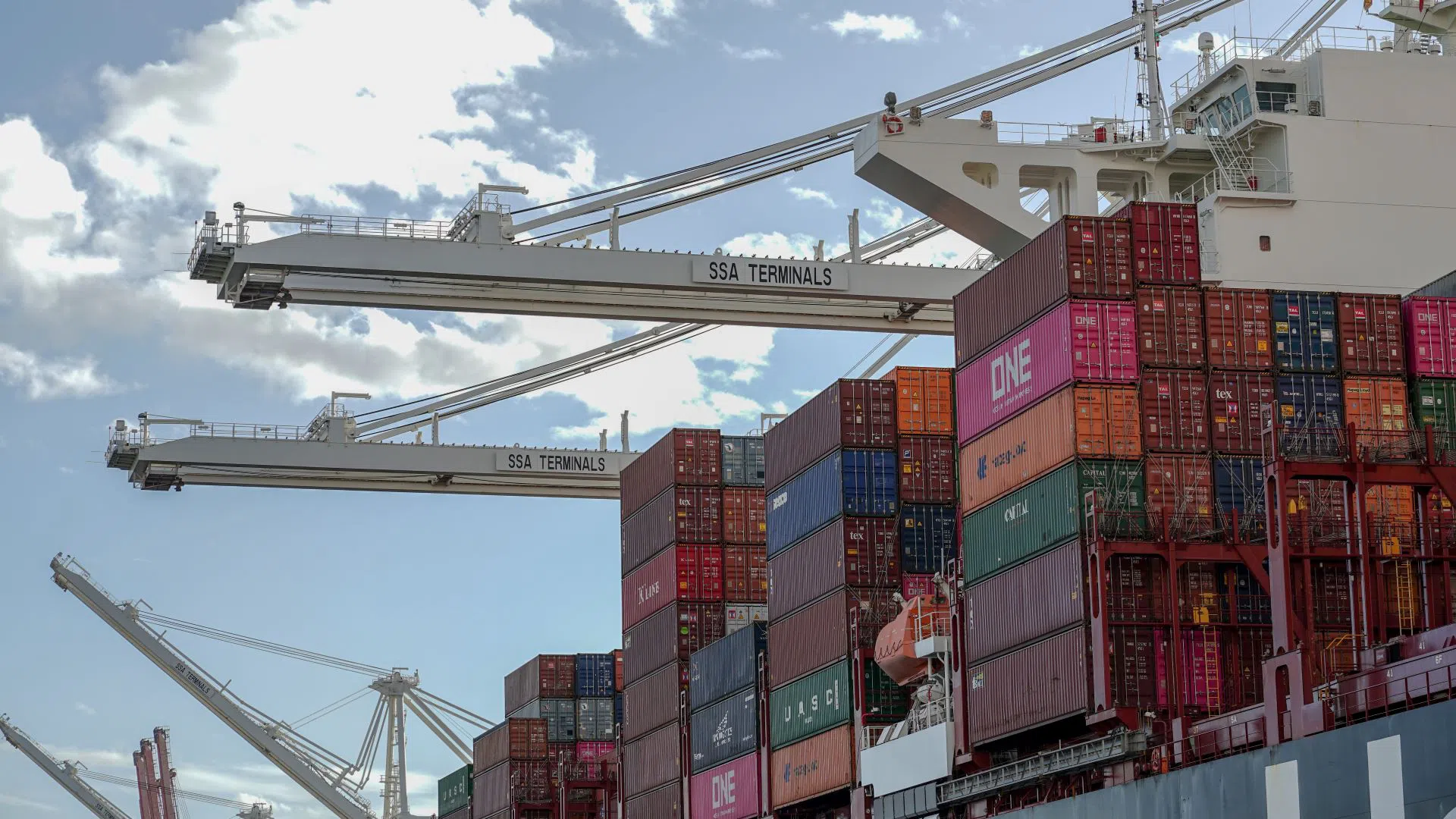
Running a successful airline means keeping planes in the air. The more time your aircraft spend on the ground the less money you make. One big difference between an airport and a seaport is that seaports traditionally set aside acres and acres of storage area for containers That allows the ship to get unloaded as fast as possible, even if there are delays getting the trucks or train cars in place. (Seaports also make a healthy amount of money providing that storage.)Sea-Tac Airport has no such buffer area. It is one of the smallest large airports in the world. So, once planes hit the tarmac you need everything, the taxiways, the support buildings, the fueling station, the terminals, the parking lots, the roads in and out, everything, set up in exactly the right ways to get passengers and cargo processed as efficiently as possible. Because the faster you get passengers and cargo out of the airport, the faster you can get your planes back in the air–and making you some money.
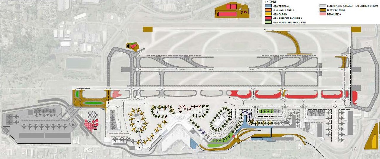
The SIMS (the ground)
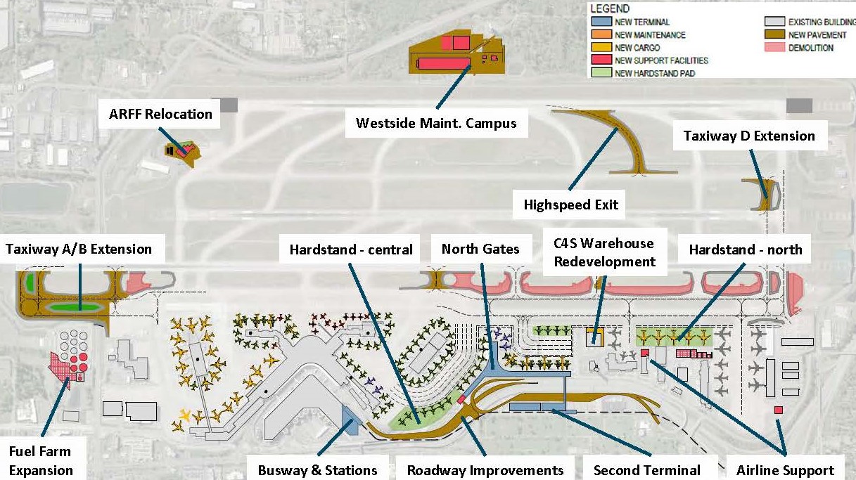
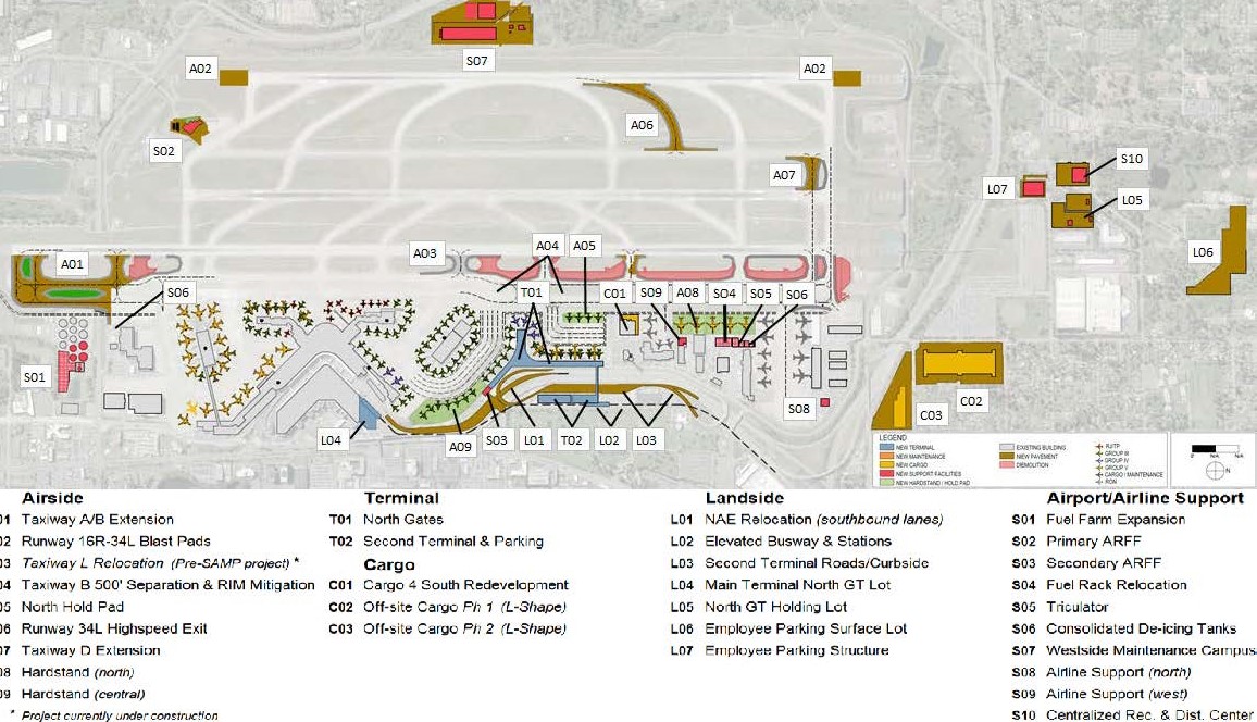
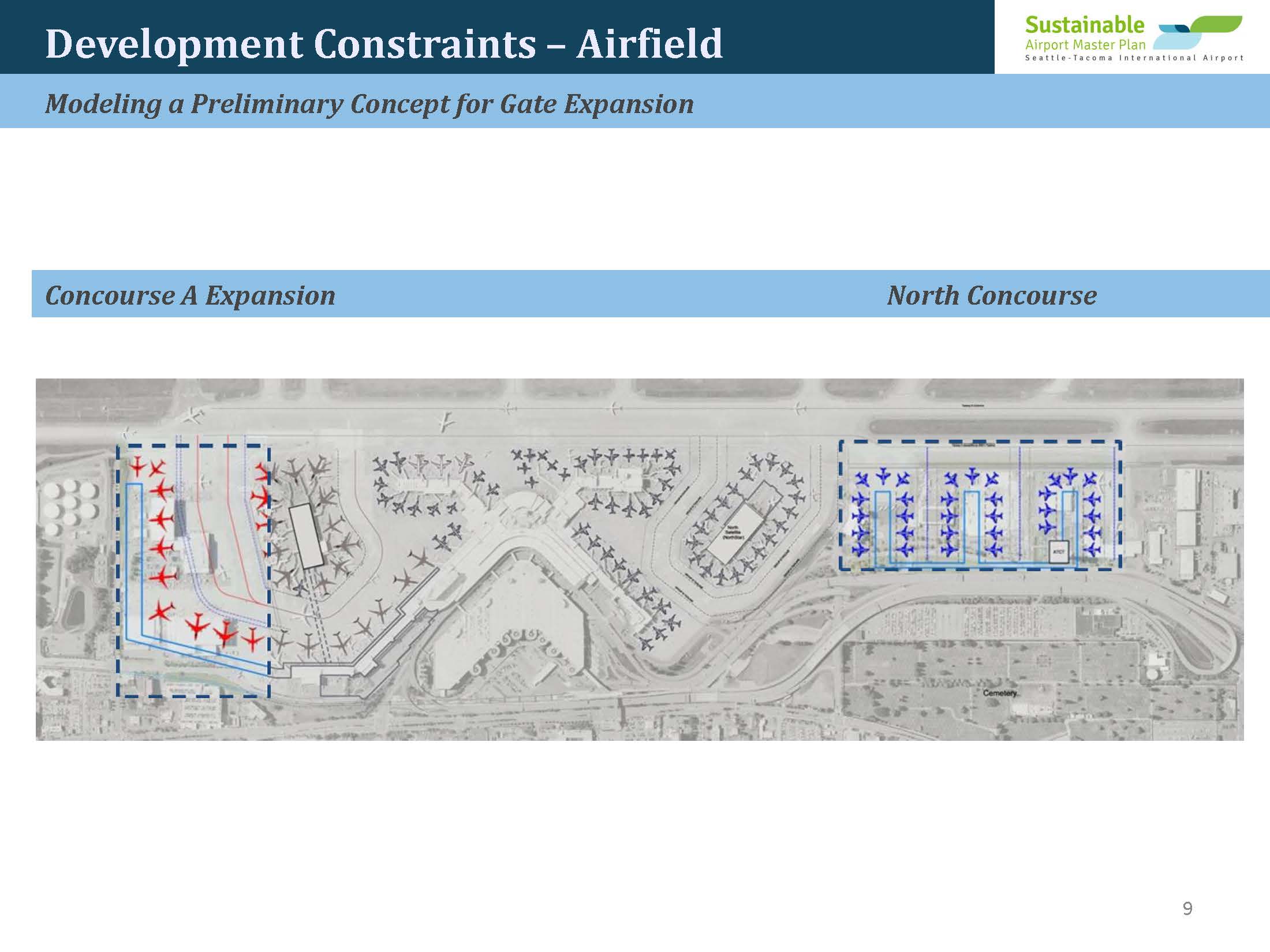
If one were to compare an aerial photo of the current airport with a similar photo in 2027, one would probably need a few moments to get oriented. Most of the support buildings will be moved around and placed in positions that are optimised for having two access points.
Airport planners now use *sophisticated modeling software to try out all sorts of combinations of buildings, gates, roadways in order to find the sweet spot for each purpose that maximises throughput. They can even model the interactions of multiple airports in a shared airspace. It’s a bit like that game The SIMS. Does this look familiar?
Now throw in a few new hard stands (parking places for planes), gates and robots (because just like seaports, gotta have them robots to automate loading, unloading and cargo staging.) OK, that’s about thirty (30) separate (and mostly small) projects that individually do not raise much obvious concern. However taken together, they constitute the Near Term Projects (NTP) Phase of the SAMP. Target date: 2027.
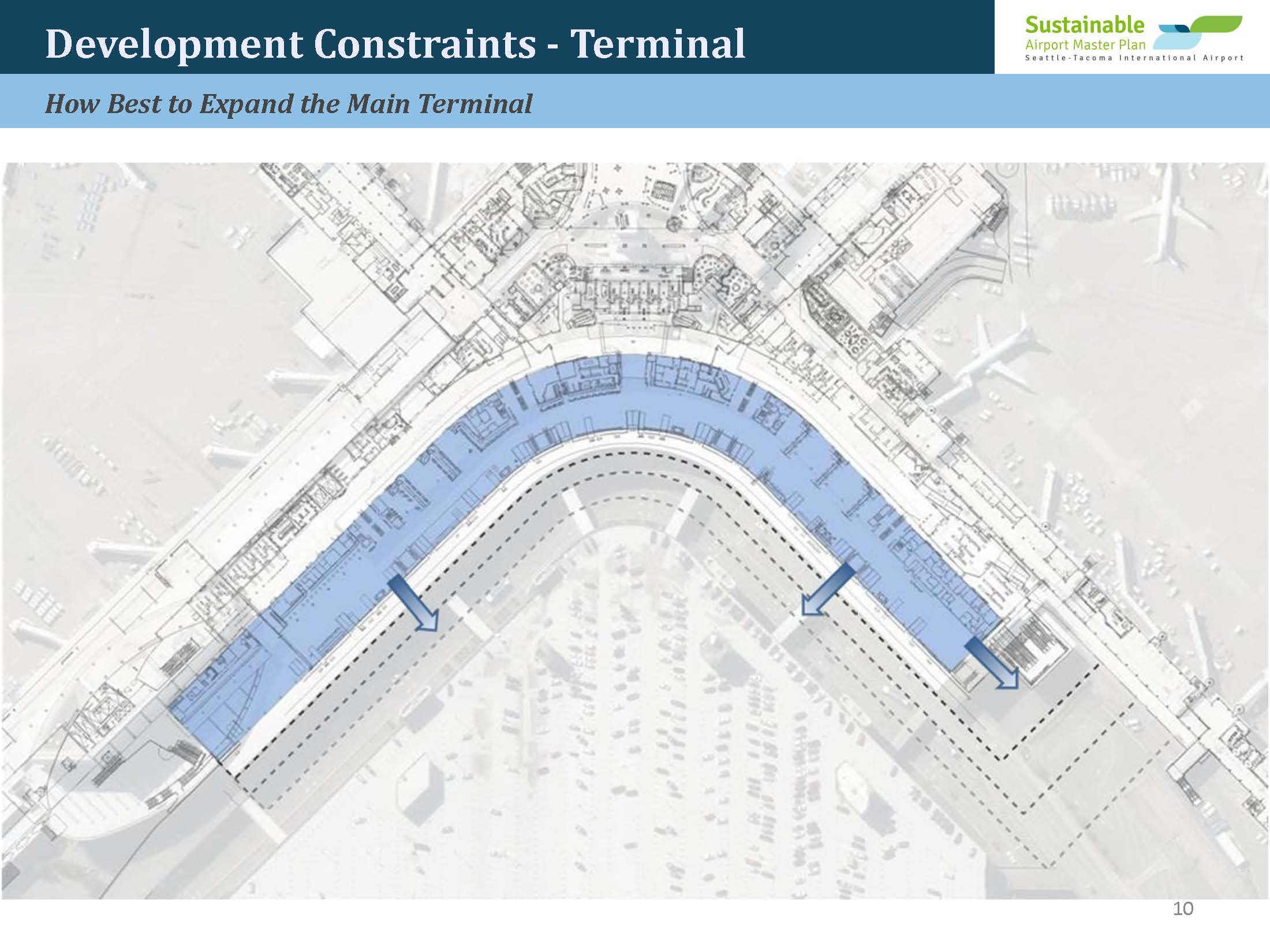
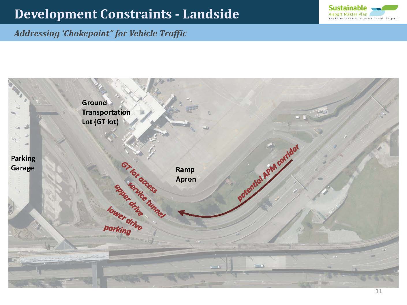
The Choke Point (the roads)
OK, you can land and take off more planes. And your airport is optimised for maximum throughput. Still that means nothing if you can’t get passengers and cargo in and of the airport as fast as you can do the other two steps.
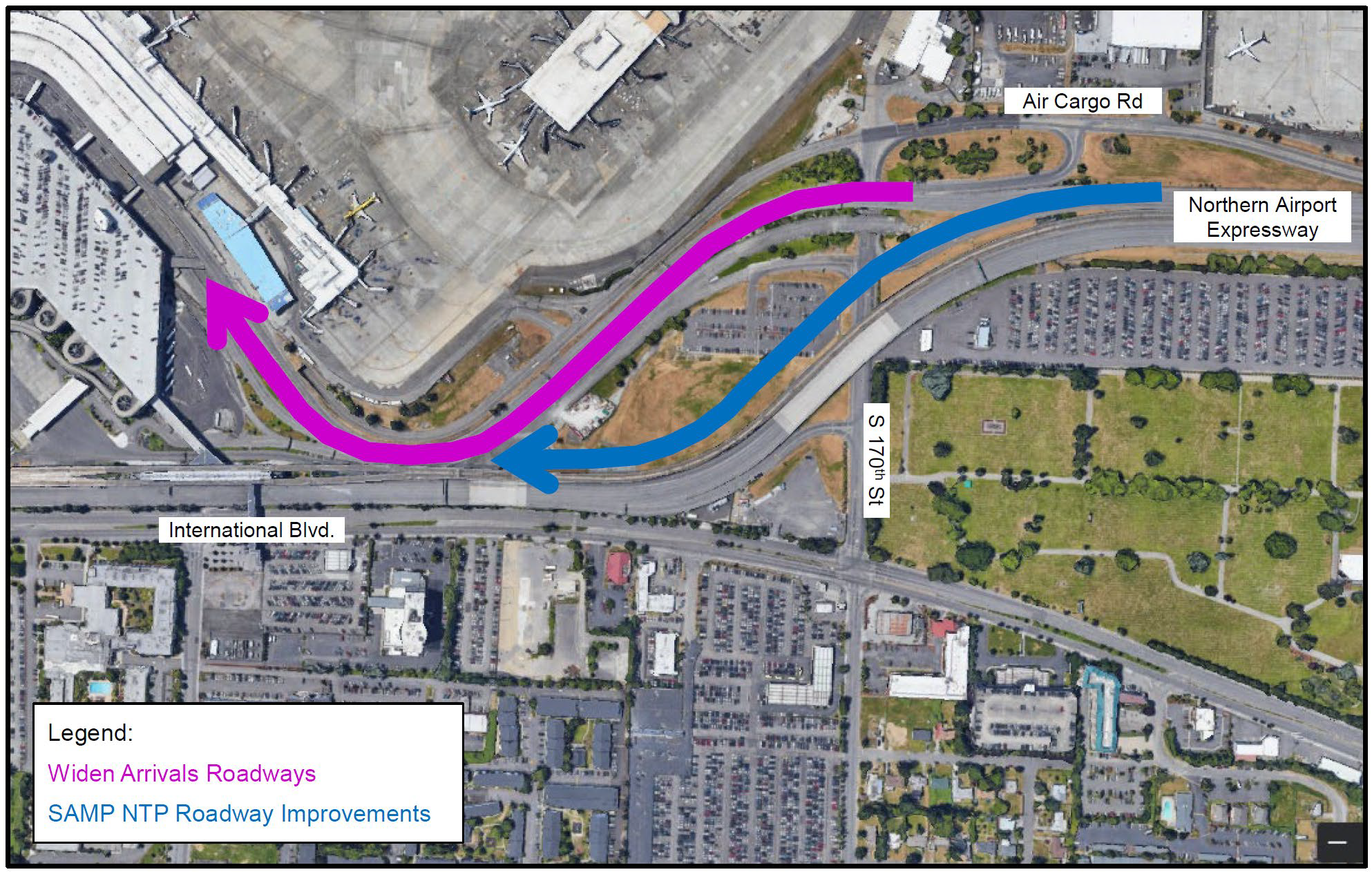
The biggest choke point at Sea-Tac Airport has always been the single main entrance/exit. The one thing that everyone (passengers, freight carriers, airlines) have always agreed on is that the northern access is a pain in the ass. Freeway. Terminal. Everything. 1If Sea-Tac planners had their way, they would be widening the Arrivals Drive right now.
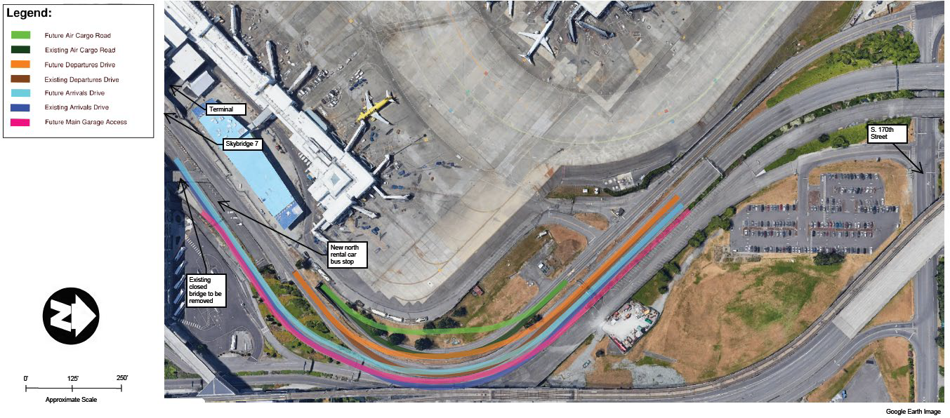
So having a southern access (SR-509) is huge. It will provide the ability to move way more people and freight in and out of the airport–and especially cargo. It will be designed from the ground up to make it easier to off-load cargo and get out of the airport. No more surface streets.
NextGen + SAMP/NTP + SR-509
That’s all it takes to reach all of the Port (and PSRC) targeted goals for the next twenty years.
That’s the Fourth Runway.
Spoiler Alert… (SAMP/LTP)
Since there is an NTP you might suspect that there would also be an LTP, and you’d be right. The Long Term Projects phase begins as soon as the NTP phase ends and is scheduled to go live by 2034. The specifics have not been published, and in fact, when the Port mentions ‘the SAMP’ it is almost always referring to the NTP. In other words, When you hear ‘SAMP’ you’re really only hearing about the Near Term Projects.
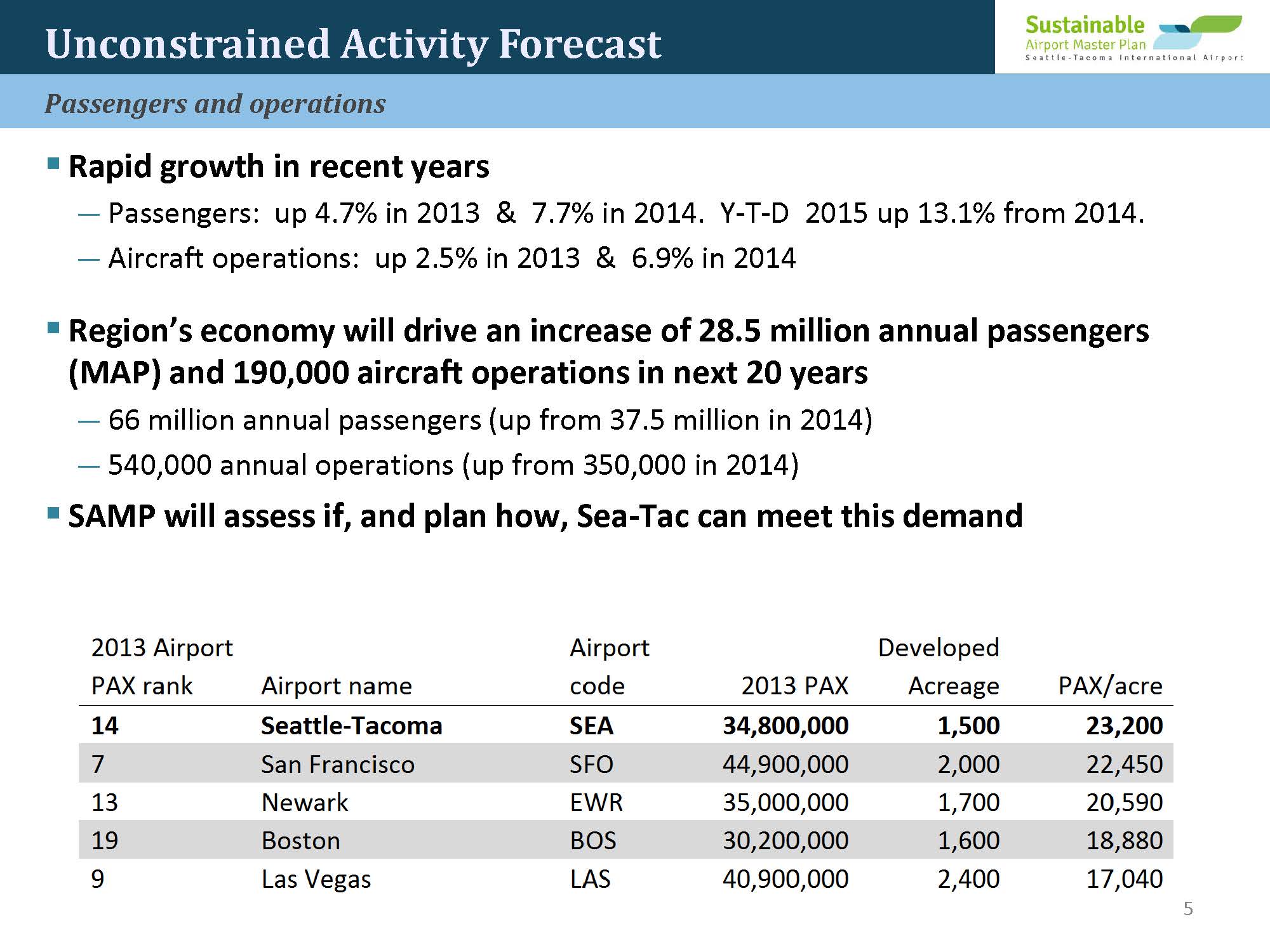
But the LTP is actually where the much bigger productivity gains will occur (ie. daily operations.) But we already know the broad strokes because of earlier presentations and the Port’s own stated goals for growth and because of a vote the Port Commission took in 2015. And that tells us the main community impacts:
- A least another 25% increase in operations
- More loss of forest and wetlands.
- The loss of any remaining noise buffer between the airfield and residences outside airport property.
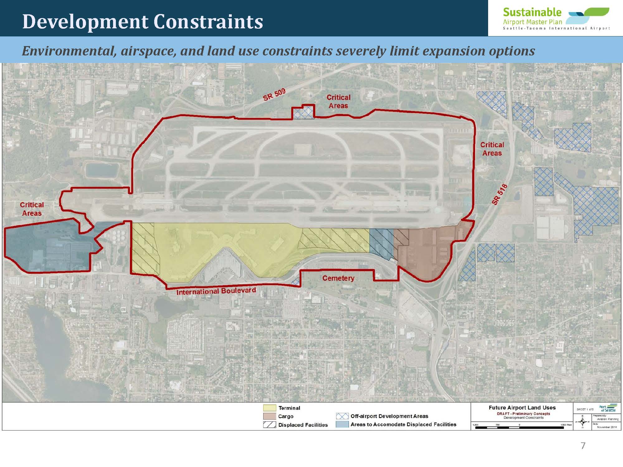
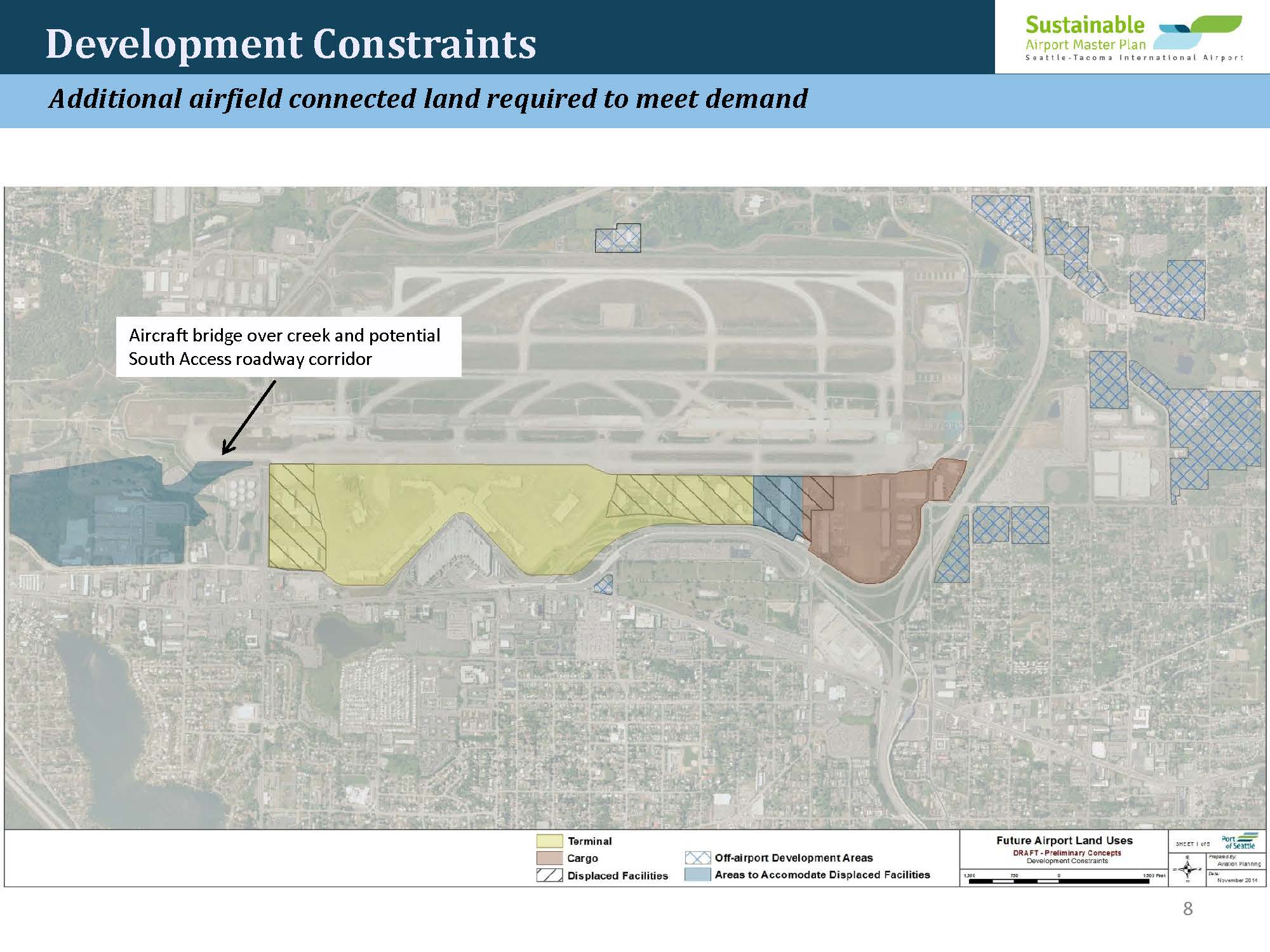
Where will this loss of natural land occur you may ask? On the only undeveloped land left on airport property of course (silly question), including the southern most fence line along 200th (note that gray area with all the parked airplanes.) Those are hardstands (parking spots.) That’s the buffer area we mentioned before.
And let’s pause for a second and reassure you that there will be no construction outside of airport property. Again, there’s no need. Coming back to 2015, the Port Commission voted not to continue planning involving the remainder of undeveloped lands because they were considered too expensive and impractical to develop. Good news for neighbours! Good news for the environment! But by 2034, the continuing demand for more operations and the money generated by all the new NTP operations will suddenly make developing those lands sound very practical.
Gee, I didn’t feel a thing…
The fact that some people will read this and see it as ‘exaggeration’ is exactly why it will happen. In fact, it’s already happening. For example:
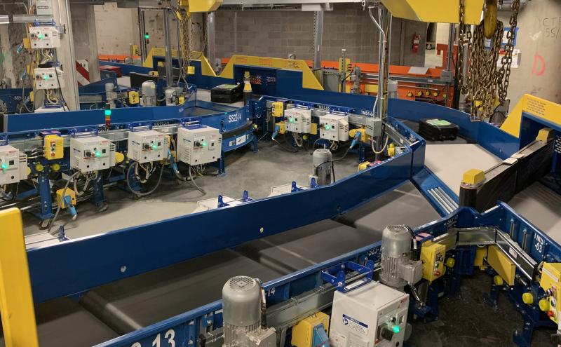
- In 2017 the airport began a complete overhaul of its baggage handline system. Much more convenient!
- And this year, the airport opened a shiny new International Arrivals Facility. Looks fabulous, right? They didn’t spend a billion dollars for aesthetics, pal. That is also part of the SAMP. It gets people in and out faster. The number of international-capable gates will nearly double from 12 to 20. That and other improvements will more than double the airport’s international passenger capacity to 2,600 passengers per hour and reduce the minimum passenger connection time from 90 minutes to 75 minutes.https://youtu.be/dy7oevZbEnQ
Two projects down. Twenty eight to go. There now, didn’t feel a thing, right? That is intentional. Promoting each of these aspects of the SAMP as separate projects diffuses public opposition. Individually, most of the thirty projects are not anything that would create obvious public concern. Many of them sound downright convenient (who wouldn’t want a better baggage handling system?) And some of them (like the International Arrivals Facility) look positively glamorous.
Environmental Review
Far worse from the community point of view is the effect this has on the environmental review process. A physical runway would require an intensive review called an Environmental Impact Statement (EIS) because of the obvious massive effects on the surrounding communities. But again, this is thirty smaller projects. So instead of considering the cumulative impacts of SR-509 and all thirty NTP projects as one Fourth Runway, the Port is arguing to regulators that each project should be considered individually. By that standard, the review will be a much less rigorous process called an 2Environmental Assessment (EA).
If this argument is successful, the likelihood of meaningful community mitigation is much less, because taken one at a time, none of these projects have much, if any, major community impacts. It is a bit like allowing a chemical supplier to routinely ship three separate, safe and inexpensive compounds to the same address, knowing that the recipient is using them to create dynamite.
It’s a factory
If all this sounds a bit like the description of an assembly line, that has been our core argument since day one. An airport is just a factory. It’s designed to process passengers and cargo as efficiently as possible. And every component, including the roads in and out, are components of a single assembly line. But the metaphor goes much deeper.

Traditional factories all share several features:
- They become the dominant force in their community.
- The factory owner uses that sheer size to market the factory as an economic benefit to the community.
- Large factories tend to be profitable largely to the extent they are able to take advantage of externalities, which are an accountant’s way of saying that the factory does not have to include waste and pollution on its balance sheet.
- As the factory is pressured by regulators to do so, it tends to resist by arguing that it cannot be profitable otherwise.
- It is the lack of proper accounting that makes it difficult to assess and in fact, factory owners resist even measuring costs accurately. No data, no problem.
- Regardless, the negative impacts are felt by people closest to the factory. But the economic benefits are always enjoyed by people far away.
Sea-Tac Airport is one of the largest polluters in the State of Washington. But airports have always benefited from the glamour of the jet age. The glass and steel of an International Arrivals Facility obscures the truth of the community impacts from all the noise and emissions. If Sea-Tac Airport’s appearance reflected its actual function, proper planning and community mitigation would be much easier.
Divide and conquer
In closing, we want to make clear a recurring theme we’ve mentioned several times, but not mentioned by name: “divide and conquer”.
- SR-509 is marketed as a separate project.
- SAMP/NTP is marketed as a separate project.
- Each element of SAMP/NTP is marketed as a separate project.
- And SAMP/LTP is not even mentioned.
For fifty years the Port of Seattle, WSDOT and the PSRC have been strategically planning all of these as a single integrated system for regional economic growth. They have recognised all along that almost all the negative impacts would be felt by communities nearest the airport while the vast majority of economic benefits would go to other areas of King County.
And decision makers have intentionally not planned in a similar integrated manner to address the cumulative negative impacts. Instead, each aspect is sold separately. Separate Town Halls. Separate hearings. Separate permits.
The economic benefits are all you can eat, but the mitigations are single-serving.
Under such a system no just mitigation is possible, especially when local governments either fend for themselves or become active accomplices in hopes of big economic development opportunities.
Regardless of motivation, local governments end up being just another part of the strategy to divide and conquer because currently there are no benefits for them that could in any way compare with the negative impacts of airport expansion. It’s simply impossible and that is why you will never hear it discussed seriously.
We’ve used two dates repeatedly in this article: 2015 and 2027. Both SR-509 and the SAMP go back many years. But it is certainly no coincidence that the final alignment of SR-509 and the basic structure of the SAMP were both sewn up in 2015. And it is certainly no coincidence they will be completed at the same time. What we now call ‘SR-509’ began as an airport project and its completion is the driving force behind the fourth major expansion of Sea-Tac Airport.
The Fourth Runway.
Post Script: Out of sight, out of mind…
We keep saying that there was surprisingly little opposition to the Second Runway construction. Evidence of that is the fact while Boeing was rolling out the 747, it was also betting the company on a second new plane: the Super Sonic Transport (SST)! Both the aviation industry and the public were that clueless as to the negative impacts from aviation. So when the FAA announced it was going to outlaw supersonic flights in 1970, it caused the regional economy to collapse.
The public could not see most of the Second Runway construction and could not imagine the effects of so many new flights .
Part of the pre-construction furor over the Third Runway was not only because of the sense of betrayal from the Second Runway. It was because people understood that there would be thousands of dump trucks building a new “Mount Third Runway” over Burien. This time they could see what was coming.
Sympathy for the devil…
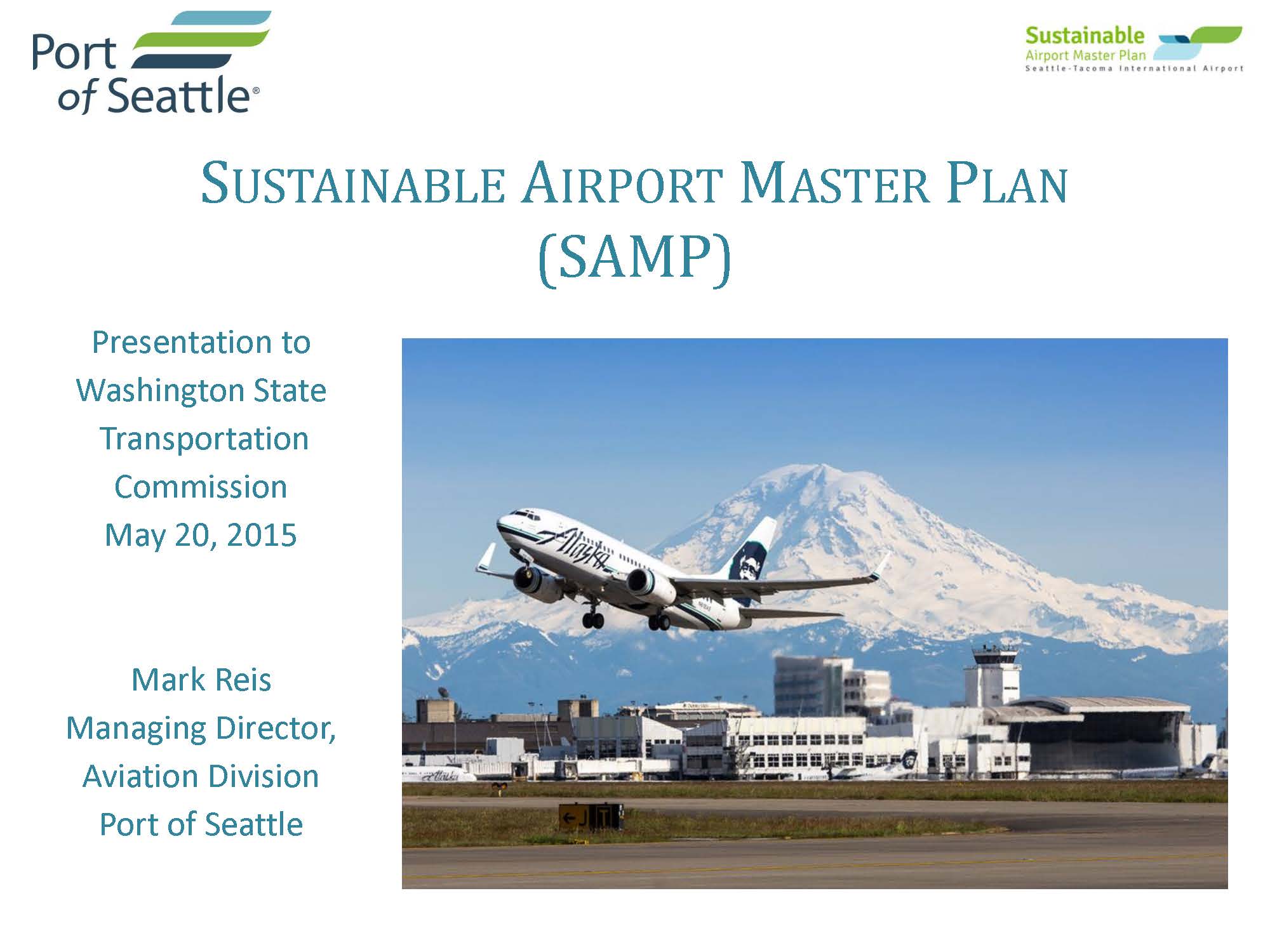
The Port and FAA get blamed for any number of things that are not their fault. Airport operators are required to signal expansion plans many years in advance and in fact, the Port began informing the cities they had plans to expand as early as 2012. (Below is a presentation from 2015 spelling out quite accurately what is going to happen.) In addition to the public not seeing any signs of construction, they also can’t know what’s coming if local governments don’t tell them and wait until the eleventh hour to respond.
OK, but not too much sympathy…
But it cuts both ways. By giving the Port over a decade to polish its approach, they have been able to polish many of the rough edges off their presentations. Going back to 2015, there was no such thing as NTP and LTP. It was just a set of specific goals that, understandably freaked out the locals. In 2017 the concept of NTP and LTP came into being. Also in 2017, and then 2020, the Port Commission tweaked their Century Agenda (their strategic objectives document) to remove most of the specifics. Those specifics haven’t gone away. They’re just not out front.
Here’s the current marketing scorecard:
| NTP | LTP | |
|---|---|---|
| Target: | 2027 | 2034 |
| Construction: | 19 additional gates (10 already completed), second terminal (IAF already completed) | 12-16 more gates |
| Environmental Impacts: | Minimal environmental impacts to airport property | Removal of remaining south end and west side undeveloped land |
| Growth Targets: | No specifics | 300% cargo, 66,000,000 passengers, 33-50% more daily flights |
See? All the freaky bits have been pushed to the distant future.
A Second Airport: The myth that just won’t die
At this point, there is always a remark, “We need a second airport!” This is one of those myths that will not die. For those who aren’t link clickers, a second airport would never, Never, NEVER lead to the reduction of even a single operation at Sea-Tac Airport. And anyone who tells you that either does not know what they are talking about or is gaslighting you: trying to prevent opposition to the SAMP. We’re so cranky about it because so much of the public wants so much to believe in a ‘magic bullet’. And by doing so have only avoided confronting the reality of how the airline business actually works.
A common misconception is to think that airport demand is a zero-sum game. For example, you might think that if we built a second airport it would compete for the same pool of business, kind of like how the Port of Tacoma and the Port of Seattle used to compete for the same container traffic until they created the NW SeaPort Alliance. Yeah, that’s not how a second airport would work.
Instead, think of a Starbucks near you. The company decides to build another Starbucks three miles down the road. Notice something? Sales at the first Starbucks do not decline. The new location simply develops its own customer-base. That is how airports tend to work.
Why? Well, in addition to the fact that a new airport takes twenty years to build, and the fact that airlines are essentially tenants at the airport and what renter wants to commit to the hassle of moving to a new building unless they have to?
If you take nothing else away from this article, we hope it’s this: an airport is a system: air, ground, roads.
Could an airline land more planes in Everett or Moses Lake? You bet. Now what? How does landing more planes in Snohomish help a passenger who lives in Seattle? Or a freight carrier who needs to get to Kent?
In the case of seaports, the Port of Tacoma and Seattle are close enough that they share most of the same logistic networks. It was a short enough distance for ships down Puget Sound that the Port of Tacoma could undercut on price, but any added cost for shippers on the ground was minimal because they had similar rail and road efficiencies.
Any new airport would be far enough away to require a completely different way of thinking about getting passengers and cargo to their final destination. In short, each airport develops a customer base that takes advantage of its location. And that advantage must be significant otherwise airlines will continue to use the highly optimised and established brand (Sea-Tac Airport) rather than commit to the unknown.
The Port of Seattle has had sixty years of experience, not only in developing and marketing the airport, but also in working with regional planners and politicians to develop the highly optimised system we’re describing in this article. For a new airport to do what Sea-Tac does so much better that it can compete on Sea-Tac’s home turf would be asking a lot.
And lest you think the analogy is unique to Puget Sound, the Starbucks metaphor has been found to hold true across the entire planet. Attempts to build significant ‘second regional airports’ have either been spectacular failures or did nothing to reduce operations at the original airport.
The Fourth Runway (aka SR-509+SAMP/NTP) will allow as great (if not greater) increase in operations than the Third Runway and it is only a few short years away. But because the public is not seeing it, and cities have not raised the alarm. they will likely not ‘get it’.
Until they get it, that is.
*One form of transparency would be if the public had access to all those model versions. If one were to attend every Sea-Tac SAMP open house where examples of planning are displayed and looked very closely, one would see that there are constant tweaks. If the public could see all these versions they could verify what is and is not technically feasible, and also what the airport planners truly have in mind.
1The Port Commissioners have stalled them previously, most recently voting to hold off on widening the Arrivals Drive, arguing that the Port should be doing more to encourage passengers to ‘get out of their cars and onto mass transit’. But it is inevitable at some point (probably 2025-ish.)
2In general, under the National Environmental Policy Act (NEPA), the difference between and EA and an EIS is simple. An EA is a concise review document taking into account the purpose and need of the proposal, any alternatives, and a brief review of the impacted environment. An EA will either result in a Finding of No Significant Impact (FONSI) or if significant environmental impacts appear likely, an EIS. The FONSI determination is made without consideration of any cumulative impacts or geographic context. An EIS is a much more comprehensive document. An EIS requires everything an EA would require while also requiring a much more comprehensive discussion of the reasonable alternatives, and a “hard look” at the cumulative impacts of the proposal along with all existing and reasonably foreseeable future development within the project area. The use of an EA rather than an EIS means that an agency is not required to assess the cumulative impacts of the proposal along with all other existing and reasonably foreseeable future development nearby. In a practical sense, EAs function as piecemeal planning due to their limited scope, while EIS’s function more as holistic, landscape-level planning
3These were the original “noise lands” purchased with FAA money and now governed by Section 163. The FAA made the grants contingent on maintaining a low population density because of the extreme noise impacts.
4Adding insult to injury, in zoning Blueberry Lane, the City of Des Moines did not hold back land from the developer for WSDOT to create a noise wall similar to those in SeaTac and on 30th Ave. If this mitigation had been available, it might have afforded opportunities for relief from the increased noise from airport operations.
ODThe SeaTacNoise.Info Over-Simplifier Disclaimer: anyone attempting to write an explainer-style article on something as complex as this have to strike a balance between readability and accuracy. And that opens the door to criticism about any number of technical details. In every case so far, we’ve found such critiques to come from insincere sources. ie. the ‘nitpicks’ are used to unfairly question the credibility to the overall premise. Our response is that this is not academia. We acknowledge that almost every sentence could have its own ‘explainer’ and hundreds of footnotes, references and citations meant only for specialists that no layperson will ever choose to read. Doing so would make these articles unintelligible for most readers. Regardless, we welcome questions, comments and critiques as a way to improve the information we provide. And we are always happy to to provide all the sources readers ask for to learn more about any aspect of these articles. Caveat Lector.
Wow, this was super concise and informative. I read through the whole thing and I’m so glad I did! I live in Des Moines and there’s a flight path directly above my roof, so this expansion is a top concern for me. Thank you for your due diligence and the effort that’s been put into this! It’s important work.