Intro
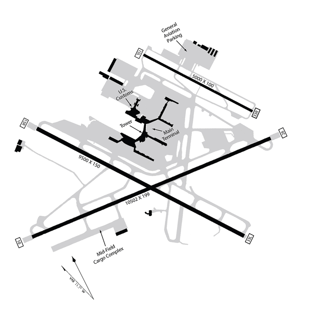
Sea-Tac is a Category IIIb certified airfield, allowing operations in all but the worst conditions, 24/7/365. There are three runways in the modern configuration beginning in 1956:
| Position | Year Built | North End/South End | Length (feet) | ||
|---|---|---|---|---|---|
| 1 | East | 1961 | 16L | 34R | 11,901 |
| 2 | Center | 1970 | 16C | 34C | 9,426 |
| 3 | West | 2008 | 16R | 34L | 8,500 |

Runways are labeled for arriving pilots
The southern ends are labelled ’34’. Right, Center, Left (from east to west), because that is about 340° compass heading. A plane arriving on 34L is coming in from the south and landing on Runway #3.
The northern ends are labelled ’16’. Left, Center, Right (from east to west), because that is about 160° compass heading. A plane arriving on 16R is coming in from the north and landing on Runway #1.
Easy, right? 😀
Length
Runway #1 was built at the dawn of the jet age. It needed to be lengthened three times in order to provide safe takeoffs and landings for the newer aircraft. By 1970, when Runway #2 opened, it could be much shorter – even with the Boeing 747 – the largest passenger aircraft ever made. And by 2004, the Third Runway could be even shorter and still accommodate all aircraft. (Which was a lucky thing since there was barely enough land to build it as is.)
However: Less runway requires faster acceleration on take-off and faster deceleration on landing. A quick climb and braking for descent require more power. More power equals more noise.
Runway separation
The distance between runways was also something of a space problem. For reasons beyond the scope of this article, the second runway (16C/34C) was built 800 ft. from the eastern runway — too close. That limited the airport’s ability to use both simultaneously. In effect, despite having two runways, they often operated more like one.
Ironically, a main driver of the Third Runway was to allow for two simultaneous operations at once. And to this day, Sea-Tac is essentially a two runway airport. When the Third Runway opened, the airport immediately began re-surfacing first the eastern, then the center runways. Having that new Third Runway, gave them the ability to do that.
Now that electronic navigation is coming on line, despite that narrow spacing, it is becoming possible to use all three at once – which is why you we now often see parallel landings.
Taxiways
All the gray roads are a network of taxiways. Conceptually, an airport is a giant parking lot for commercial aircraft. The taxiways are the on-off ramps from the freeway to get the aircraft to and from their parking spaces. No matter how many lanes a freeway has, consider how backed up it can get if even one of the exits becomes clogged.
These taxiways became far more elaborate with the Third Runway. In fact, when you hear ‘Third Runway Project’ it would not be a stretch to call it “Taxiway Redesign–with Additional Runway Project” because those taxiways are almost as important to throughput as the runways.
To emphasize the importance of taxiways to throughput: note that a major portion of the SAMP is the redesign of two of those taxiways.
Taxiway Tango
 Note the north/south taxiway running the entire length of the airfield just west of the center runway. That’s called Tango. And there is a pretty good chance that when you first opened this article, you mistook Tango Taxiway for a runway. It’s not a runway. But don’t feel bad about it – so have any number of pilots over the years. 😀 However, other than cost, there is nothing preventing the Port of Seattle from swapping that taxiway and the 16C to make the configuration more like what it perhaps should have been all along. We only mention this to keep pressing the point out that there are all kinds of ways to enhance throughput using just what is already on the airfield.
Elevation
The airfield seems ‘flat’ but is not level. The north end is about seventy feet higher than the south, give or take, and each runway is slightly different. That is because the airport is built on a plateau with a similar, natural rise. Making it truly ‘level’ would have added unbelievable engineering costs and been even more damaging to the environment in both the short and long term (eg. drainage). As with everything else, the FAA has rules on this, and the less than 1% slope of the Sea-Tac airfield is considered modest.
Going With the Flow
 Flight operations on all runways, both departures (take offs) and arrivals (landings), move in one direction at any given time. That is called flow. When Sea-Tac entered the jet age, its runways were re-aligned north and south according to the prevailing wind patterns of our area. So operations occur in either North Flow or South Flow.
- North Flow means the planes are arriving at the south end runways (34R, 34C, 34L) and taking off from the north end heading northward.
- South Flow means the planes are arriving at the north end runways (16L, 16C, 16R) and taking off from the south end (34R, 34C, 34L) heading south.
Confused? It gets better. We’re spending some time on this because there is also the related subject of flight tracks, which means the paths taken through the sky by those arriving and departing aircraft. They will look like a mess of green and red until you are clear on the concept of flow.
Here are some examples of flight tracks in both North Flow and South Flow and a deeper dive into what it means for the region.
Why bother changing direction?
In general, aircraft take off by flying into the prevailing wind direction. If the wind is coming from the north, the airport uses North Flow. If the wind is coming from the south, the airport will use South Flow.
When those prevailing winds change, the airport goes through a process where they switch Flow. This doesn’t happen all that often because despite the reputation of Puget Sound, prevailing winds are fairly consistent with the seasons. In fact, South Flow is used about two thirds of the year–almost always during the colder/cloudier months.
Changing Flow seems to be occurring less and less as traffic increases, partly because modern jet engines are so powerful that the wind direction no longer has as much of an impact on safety. That said, favorable wind direction requires less power, which saves fuel and also means less community noise. 🙂
And sometimes the Flow of the airport is chosen based on scheduling requirements. Sometimes the cost and hassle of switching Flow doesn’t pencil out for an airport as busy as KSEA.
Brief History
If we were starting over, we might re-title the entire project, “Sea-Tac Airport in the Jet Age.” Because the real history of the airport begins with the arrival of commercial jets. We only spend time on ‘the good old days’ where it is relevant to later events in the community.
- 1956 First jet-capable runway
- 1958 First runway extended
- 1961 First Runway extended again to its final length with ‘cap’ over 188th St.
- 1970 Second Runway
- 2008 Third Runway opens
Pre-History: 1944-1956
Here is the original ‘X-rated’ version of the airport. The main purpose here is to give the reader some context of the Surrounding communities. One tiny note: given the configuration, even then one had to question the whole notion that “airplanes must take off into the wind.” Yes, but do they, really? 😀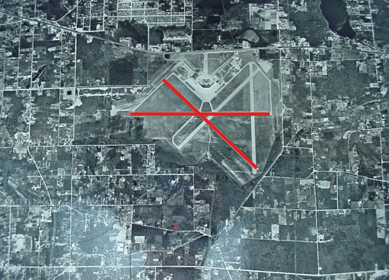
Sea-Tac Airport in the Jet Age
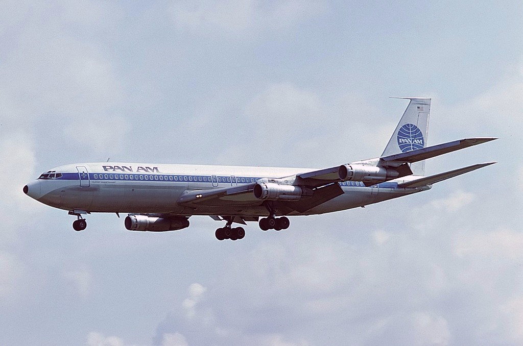 As we said, the real history of the airport begins with the arrival of this bad boy, the Boeing 707 first flown by Pan Am Airlines.
Jet engines enabled the industrial scale growth of aviation. Jet engines can carry more people, more cargo and fly much faster. But what matters most for this discussion is the fact that they require much longer runways.
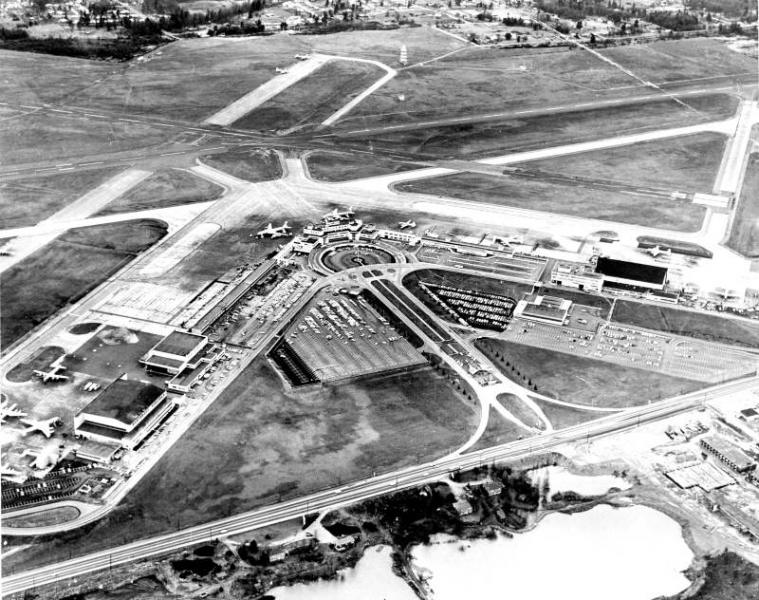
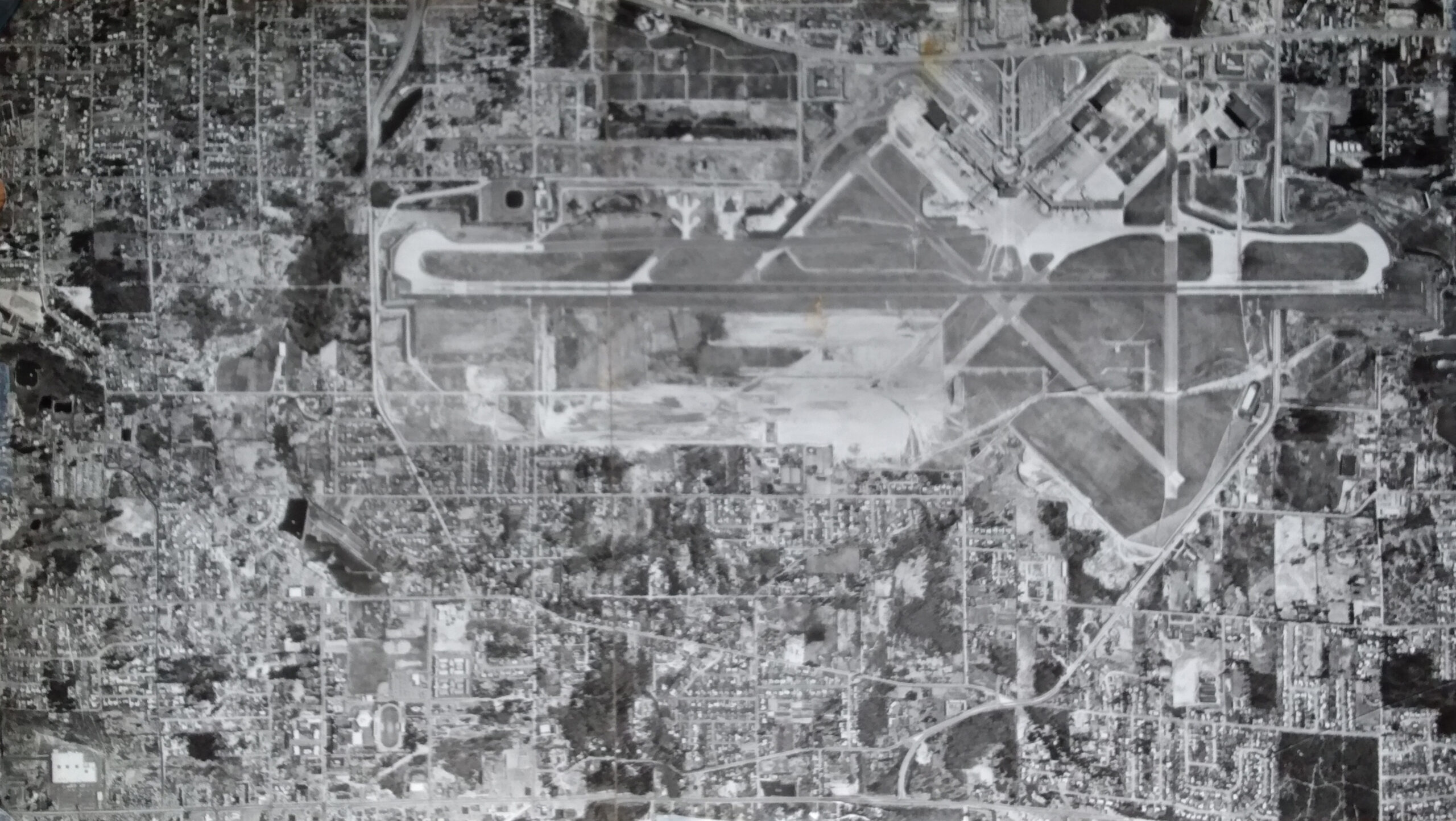
This is 1961, the final extension of what is now the ‘First Runway’, extended for the third time to its final length with ‘cap’ over 188th St. We like it because you can see the ‘vestigial organs’ of the original runways, which were still heavily used for general aviation. Note all the empty land in front of Pacific Highway, now covered by the circular parking garages.
And here is the second runway under construction, showing clearly that ‘cap’ over 188th.