
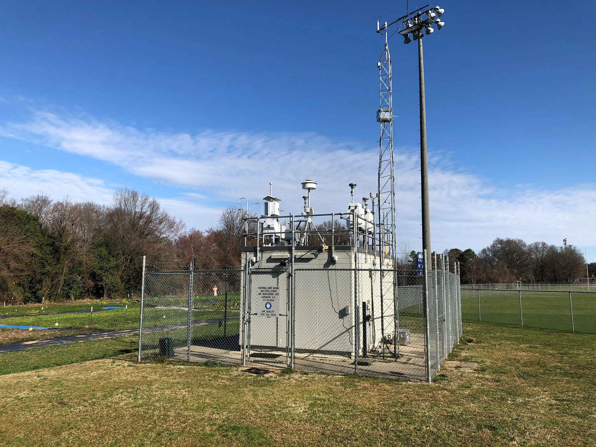
This is a fixed site air quality monitoring (AQM) station. If your first reaction was, “So what?”, skip to the bottom, we’ll wait. You can view this as a stand-alone device, or you can view it as one node in a network of AQMs, which work together to allow for researchers to capture a much bigger picture about air quality in a given geography.
Whether stand-alone or network, AQMs requires three basic things:
- A protocol (the monitoring procedures)
- The hardware (the land, the fence, the sensors, etc.)
- And an agency to run those procedures and manage the gear.
One-time money
You need several one-time purchases to create a network of AQMs.
The design protocol
Before anything else, you need to hire an expert to create a monitoring protocol. ie. “Here is the hardware you need and here are the procedures we’re going to do to collect and report on the data, year in and year out.”
The site
After that, you need the ‘site’.
- A small piece of land that you control (it can be as small as 10’x10′)
- A source of power
- A fence to provide security and maintain a chain of custody
- A structure (a hut) to house the equipment.
The sensors
 You then need the gear that goes inside the hut. Sadly, there is no universal sensor (like the Tricorder on Star Trek.) So you need to purchase separate sensors for each pollutant you wish to monitor. Just a few examples…
- Ultrafine Particle counter/sizer
- NOx
- SOx
- PM2.5
If your high school chemistry is a bit rusty, don’t worry. All you need to know is that all those are pollutants coming from all fossil fuel powered machines. But there are many, many other aviation-related emissions that scientists would like to monitor, either now or in the future. More on that below.
The technician
You need to pay someone to go out and periodically read the meters and calibrate the gear.
The annual report
Finally, you need to pay someone to periodically publish the data and write a summary report for researchers and decision makers.
Again, these are all one-time purchases. But, and this is key, some of them (like the technician and the annual report) need to be made periodically.
The key is the agency
What really makes it a network is this: the managing agency. That is what makes it persist and gives the data legitimacy. That is what gets you to regulatory authority over any pollutant: longitudinal, comprehensive and controlled sampling and reporting by a legit regulatory agency.
As a regional arm of both the State and the EPA, Puget Sound Clean Air Agency (PSCAA) has both. And this year PSCAA is installing the first air quality monitoring station near Sea-Tac Airport.
PSCAA has, in essence, created the one node network for aviation emissions.
Now, we just need three more nodes. Because that is what scientists have been asking for since the 1970’s.
You want to be able to ‘see’ in real time, the flow of particles on all four points of the compass over the airport. Just as we now can for noise events with the Airport’s 24 Permanent Noise Monitors.
Why do we need a network?
Current questions
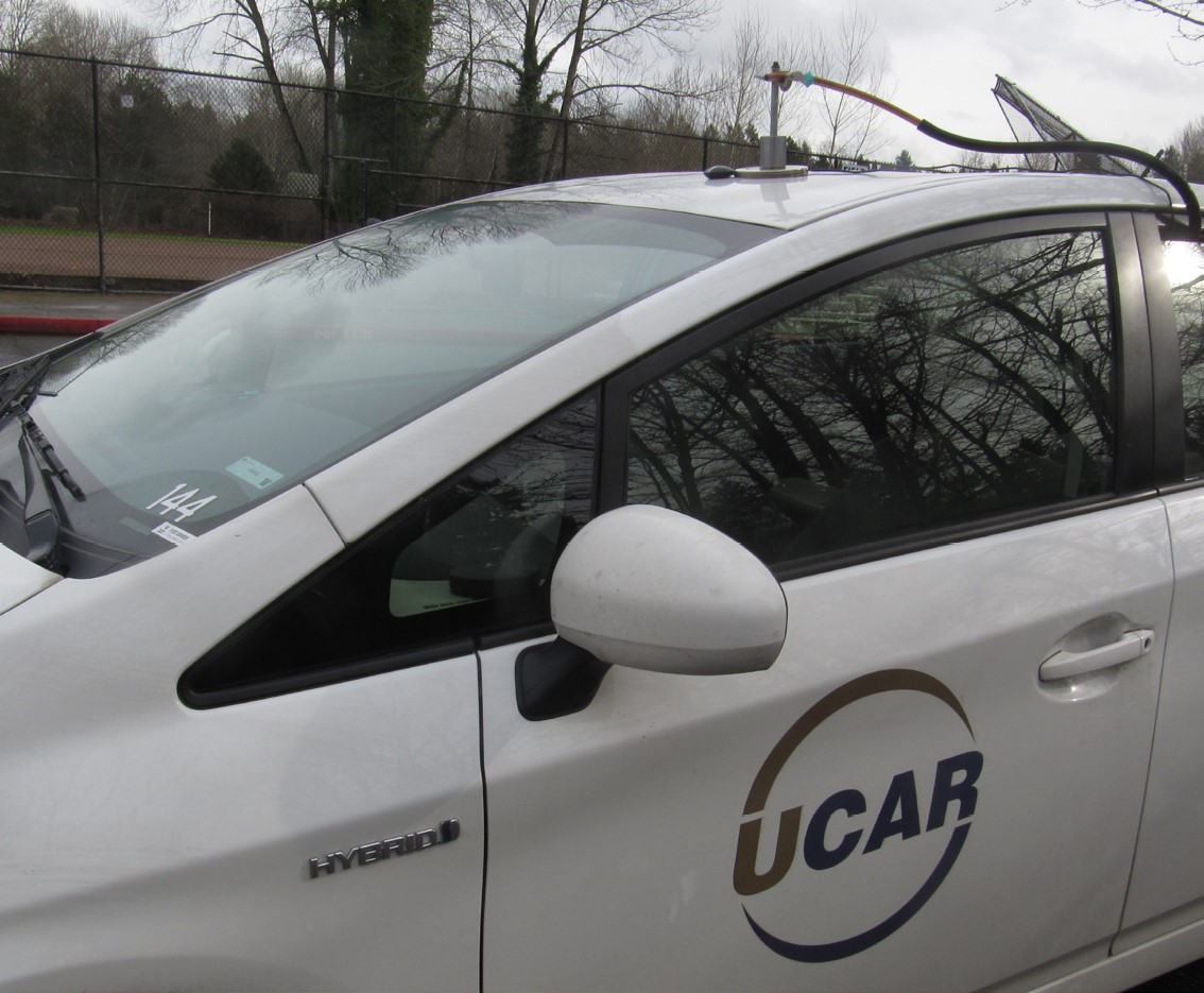
Not nearly enough is known about UFPs. There are many questions that simply cannot be adequately answered, even with creative programs like MOV-UP. Here is just one example.
There has been an ongoing controversy in the field over something called ‘spatial dynamics’, ie. how do various particles disperse from an aircraft as it flies overhead. That pattern varies depending on many factors, including weather, time of day, and not least of which being the type of particle in question.
The spatial dynamics of many particles are fairly well understood, so placement of nodes is non-controversial. However, many pollutants, like UFPs and ceramic coatings, have not been studied enough to know how these factors change. Some researchers might feel like one monitor is adequate for the entire area. While others (UWDEOHS) feel that there is enough variability that several nodes are required to capture data thoroughly enough to correlate with population studies. In short, we don’t know what we don’t know.
Future questions
 The advantage of having multiple nodes protects the future. UFPs are under-studied. Many other aviation pollutants (coatings, metals) have never been studied.
This is another flavor of a monitoring station that could fit within the same footprint. It looks very different, but the only difference is the gear inside.
By siting a comprehensive network, it provides for the initial sampling opportunities, but it also allows researchers the ability to study new items of interest quickly. As soon as researchers identify a new interest they can simply add new gizmos and begin sampling immediately.
 Remember where we mentioned ‘chain of custody’? That means that you can guarantee that the data you sampled was handled in a constant and uniform manner. You can only get that with a fence and a fixed-site monitor.
Without this framework, every time researchers want to study something they have to ‘get creative’, ie. do one-off mobile studies like MOV-UP, which are ingenious, but not only take new funding to conduct but then have to be replicated later within the fixed-site framework in order to get to that regulatory standard.
The network has practical benefits for now, and it also speeds research for the future.
Equity
One other important reason to site multiple nodes is to further environmental justice. Providing monitoring in areas consisting of traditionally marginalized populations demonstrates a sincere will to capture data for the entire community.
What is not a network?
Both sites referenced in this document are from the same city. However they do not represent a network, for the simple reason that they obviously do not contain the same gear and are thus not measuring the same things. That points out the key flaws in every previous attempt to monitor aviation emissions.
- Most cities with multiple fixed site monitoring stations stock them with different equipment–because they assume that each site has different needs.
- A few cities have installed multiple identical fixed site monitors–specifically to monitor aviation emissions. However in every case this has been only for short durations. ie. to perform one-off studies.
As far back as 1976, researchers understood the need to establish a matched network of air quality monitoring devices around Sea-Tac Airport. With long term, 360 degree, monitoring of the entire air shed, an AQM Network would provide an unparalleled data set that would be invaluable to scientists throughout the world for decades to come.
Summary
There are two aspects to building an aviation-centric air quality monitoring network
- One-time money to buy the land/equipment and establish the protocol.
- Agency management to run it year in and year out.
The good news:
Thanks to Representative Tina Orwall/Senator Karen Keiser (both 33rd LD), UWDEOHS and PSCAA, this year, Sea-Tac Airport will get a one-node network. The State provides the one-time money, UW provides the protocol, PSCAA provides the management.
Now the challenge is simply to add more nodes. To do that we need to:
- Work with Cities and private property owners to site more 100sq ft. plots of land
- Keep the flow of one-time money going for all those separate (small) purchases
- Encourage PSCAA to add more nodes, with the assurance that they will receive the funds they need for hardware and staff time. This can be done via Federal or State agreements.
Coda: No data, no problem.
If you go to the PSCAA web site, you’ll find what looks like a very comprehensive AQM network map. However, their network is designed to monitor only roadway emissions, not aviation-specific emissions (like ultrafine particulates.)
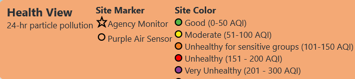
See all the little green dots? Those are PurpleAir sensors–like the kind anyone can purchase. They’re fine for informational purposes.
Next, notice the big green stars. Those are the Agency fixed site monitoring stations; the ones with the fence and the hut which regulators pay attention to.
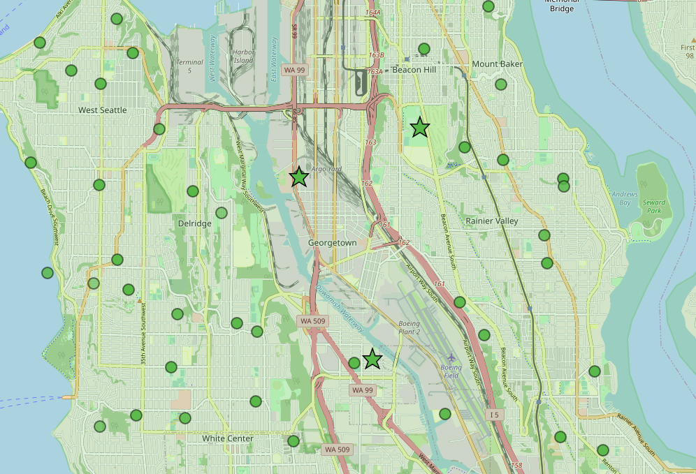
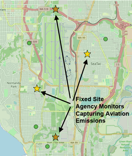
Now let’s scroll down to the PSCAA monitors near Sea-Tac Airport. Notice something missing? No big green stars. There are literally no fixed-site Agency-controlled monitors anywhere near Sea-Tac Airport.
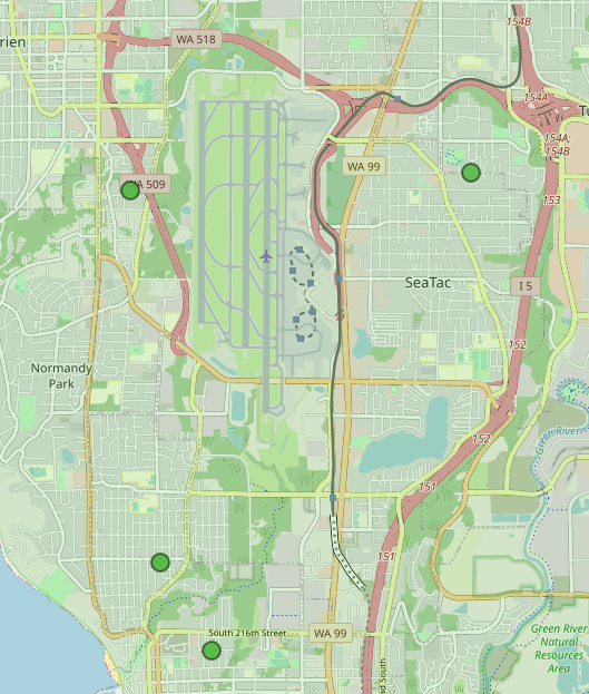
But even if there were…
But whether they’re dots or stars, notice that all those sensors are green. Which means ‘Good’, right?
Green = Good!
According to every map published by any arm of the State and Federal government (including the new AirNow.Gov) the air over Sea-Tac Airport is always in the best possible range.
WTF?…
Remember Mr. Spock and his Tricorder? Sadly, PSCAA does not have them. Again, all their sensors (expensive fixed site or inexpensive PurpleAir) are designed only to measure a very small set of pollutants, specifically the ones they are already authorized by the State and Federal government to regulate. Those include emissions from cars and trucks and wildfires, but, wait for it, not aviation emissions.
This bears repeating: until now, PSCAA has not measured aviation emissions because they have no authority to regulate aviation-related emissions. Their job was (and still is) to measure what they can do something about.
So even during the peak periods when aircraft are flying over our heads every 60 seconds, with all those tons of nasty emissions all their monitors will almost always show ‘green’. And that is because they have literally not been measuring what is actually flying over our heads.
In the world of environmental engineering this phenomenon is known as “No data, no problem.” You cannot regulate a problem if you do not have the evidence required by statute to show that it exists. And yet you cannot gather that evidence until you have that regulatory statute. Oy.
And that is why we need an AQM Network around Sea-Tac Airport that captures the entire air shed, over time. Just like we do for wildfires and roadway emissions. To get to that regulatory standard, somehow, we need to capture the data before those regulations actually exist.
That is not a slam against PSCAA. That is the law. From a certain point of view, PSCAA are now going above and beyond by measuring ultrafine particulates (which they still cannot regulate) at even one site. We only mention this Catch-22 as the final hurdle to obtaining a true network.
PSCAA will need not only an assurance of funding, but also encouragement that their efforts to establish that network are the best use of their limited resources–which will still be subject to competitive pressures from other important forms of air pollution.
Finally, with a proper Air Quality Monitoring Network, one that does capture aviation emissions, here is how a typical day might look around Sea-Tac Airport.
The dots (the PurpleAir sensors) still show green because they don’t capture aviation emissions. But some of the *big stars (the monitors run by PSCAA) now more accurately show yellow and even orange to reflect the presence of all those ultrafine particulates. They track emissions on each side of the airport so researchers can see how operations across the entire air space contribute to the overall load we all breathe in.
This isn’t just for researchers. We all need be able to see this in action to get to regulatory authority and cleaner air for everyone.
*The precise location of each site would be determined by researchers.