TagMap(375)
-
 2021-11-01
Lake to Sound Trail – Segment C Sea-Tac: Contract KC000383 Contract Plans
This document contains the contract plans for the Lake to Sound Trail – Segment C in SeaTac, Washington, covering the trail corridor from S 200th Street to the 8th Avenue S / Des Moines Memorial Drive intersection in King County. The project, managed by the King County Department of Natural Resources and Parks, includes engineering drawings for trail construction elements such as boardwalks, drainage, signage, and intersection improvements within the city limits of SeaTac and Burien. The conformed drawings, dated November 2021, were prepared by Parametrix engineering and reflect updates from project addenda. -
 2021-09-09
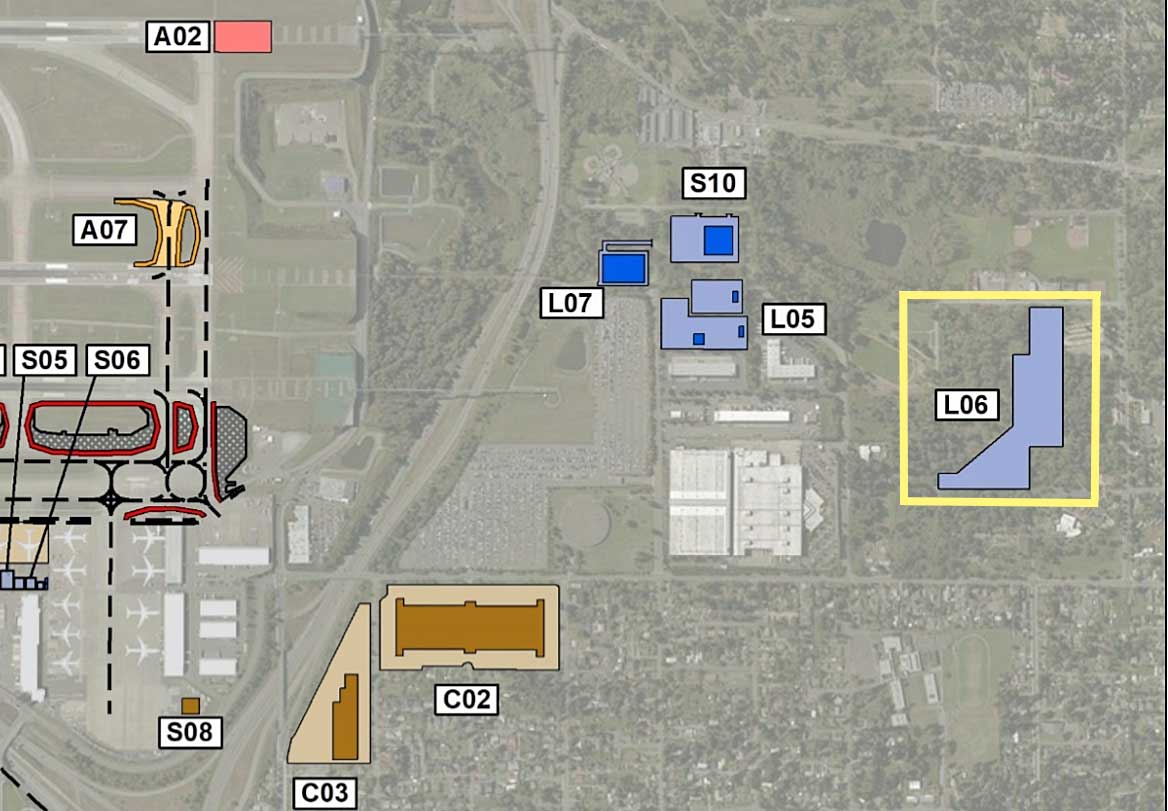
Sea-Tac Airport Parking Lot L06 Site Map
An aerial map overlay showing labeled parcels or project zones (A02, A07, S05, S06, S08, S10, L05, L06, L07, C02, C03) near what appears to be a major airport, with color-coded polygons indicating different land use or development categories. Zone L06 is highlighted with a yellow border, suggesting it is a focus area in this planning or noise-policy document. -
Topographic Map.com (King County)
Topographic Map is a free Internet site that aggregates content from ESRI and OpenStreetMaps to create heat maps for given areas. This particular image shows the plateau (partially man-made) on which the airport sits. -
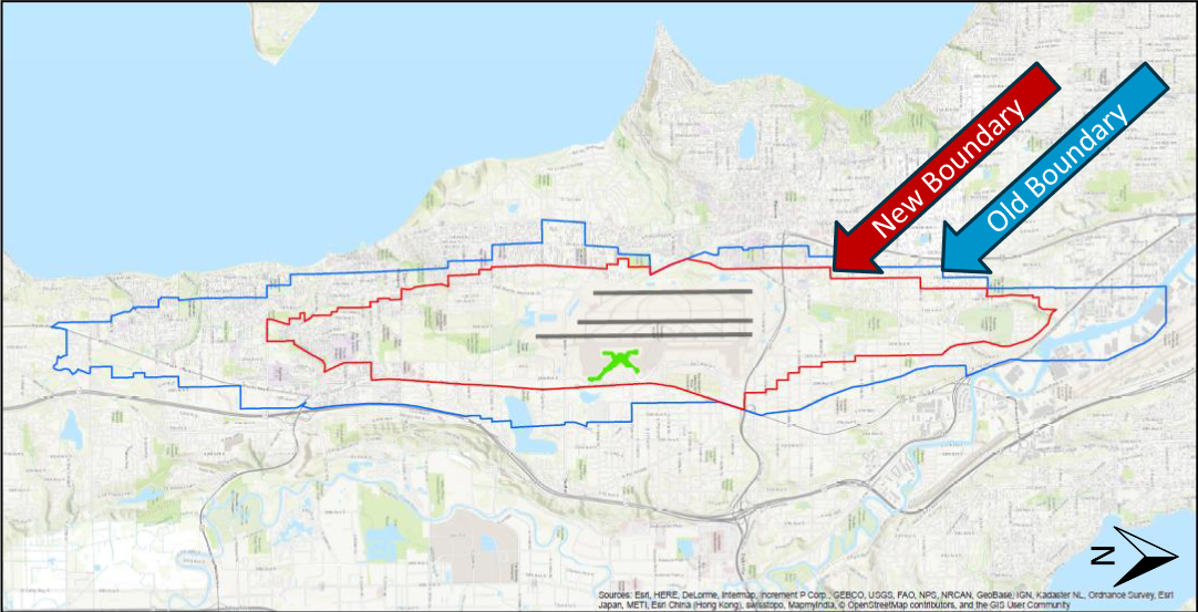
2021 Projected Noise Boundary Map
A GIS map comparing the old noise boundary (blue line) and new noise boundary (red line) around Seattle-Tacoma International Airport, with runway layout and airport symbol visible at center. Map data credited to Esri, HERE, DeLorme, Intermap, GEBCO, USGS, NPS, NRCAN, and other contributors. -
 2021-05-14
Port Of Seattle Equity Index user guide and FAQs
The Port of Seattle Equity Index is an interactive online mapping tool that displays community indicators—such as race, livability, accessibility, and education—across King County, Washington. Developed by Community Attributes Inc. for the Port's Office of Diversity, Equity, and Inclusion, it allows users to explore data by city, address, or custom-drawn area to better understand factors affecting equity and access to opportunity. The tool is intended to support decision-making, strategic planning, and community engagement, though it does not represent an exhaustive picture of all equity-related community characteristics. -
 2021-03-01
Lake to Sound Trail – Segment C: 100% alignment
This King County map document shows the planned alignment for Segment C of the Lake to Sound Trail, a recreational trail corridor connecting Burien and SeaTac. The 100% alignment, dated March 2021, traces the trail route along Des Moines Memorial Drive and through residential areas near Des Moines Creek, terminating near Des Moines Creek Park at S 200th Street. The map was produced by King County's Department of Natural Resources and Parks, Parks and Recreation Division. -
 2020-02-21
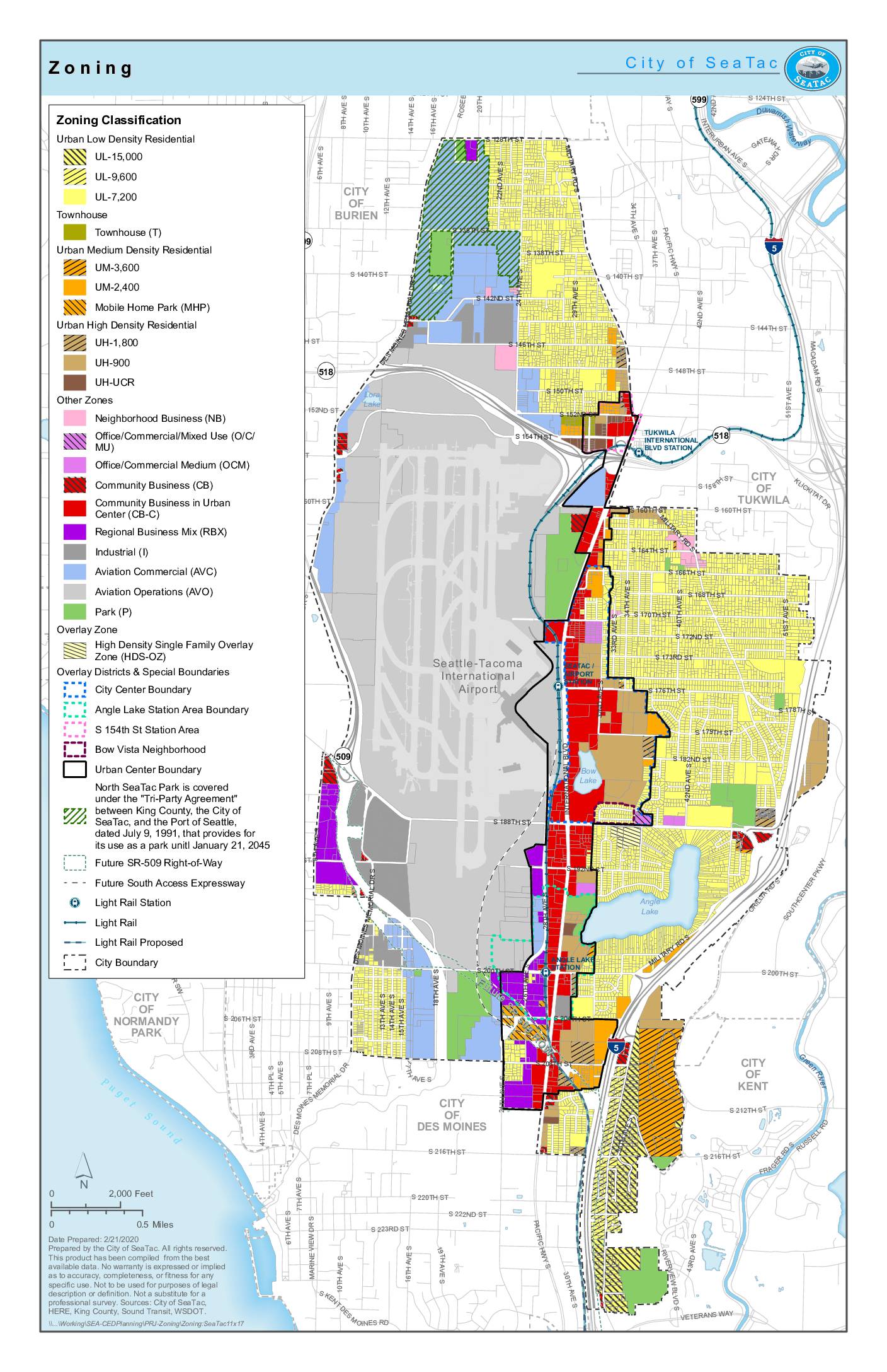
City of SeaTac zoning map
This is the official zoning map for the City of SeaTac, Washington, prepared in February 2020, showing land-use classifications across the city. It covers a range of zones including low-, medium-, and high-density residential areas, commercial and industrial districts, aviation-related zones, and parks, alongside overlay districts and special boundaries such as the Urban Center and Angle Lake Station Area. The map also depicts infrastructure features including light rail stations, the Seattle-Tacoma International Airport footprint, and planned future rights-of-way for SR-509. -
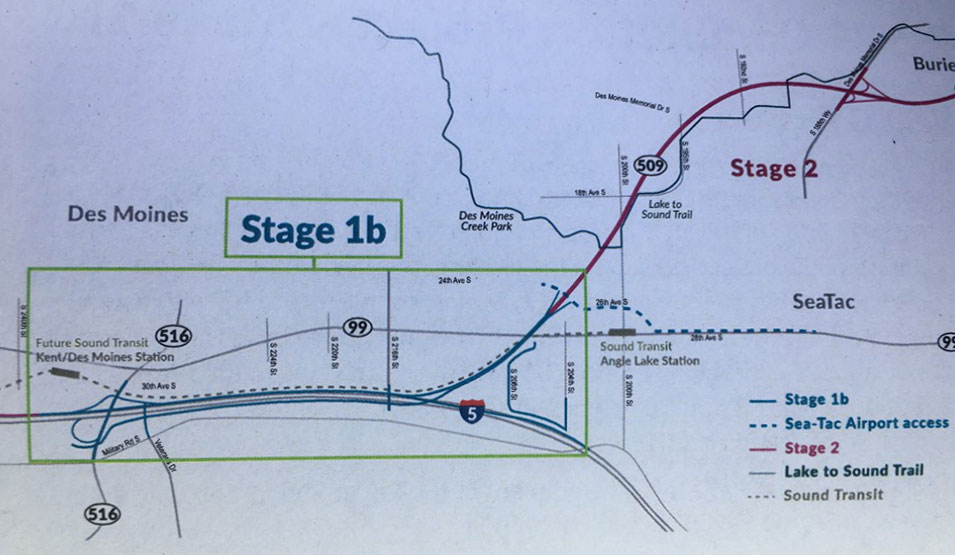
SR509 Completion Project I-5 Connector Overview
A planning map showing Stage 1b and Stage 2 alignments of the Lake to Sound Trail in the Des Moines and SeaTac, Washington area. Key landmarks labeled include Des Moines Creek Park, Sound Transit Angle Lake Station, the Future Sound Transit Kent/Des Moines Station, SR-509, SR-516, SR-99, and I-5, with trail segments distinguished by color-coded legend lines including Sea-Tac Airport access routes. -
Sea-Tac Communities Plan Chapter 6 Maps (South Reinforcement Area, Program Application)
This is an excerpt from Chapter 6.6.5 of the Sea-Tac Communities Plan (1976). ‘Reinforcement’ was one of three types of planning that were considered. It refers to efforts to strengthen the existing community to be more compatible with the airport through the techniques of property buyouts (to create a noise buffer) and sound insulation. -
 2019-01-01
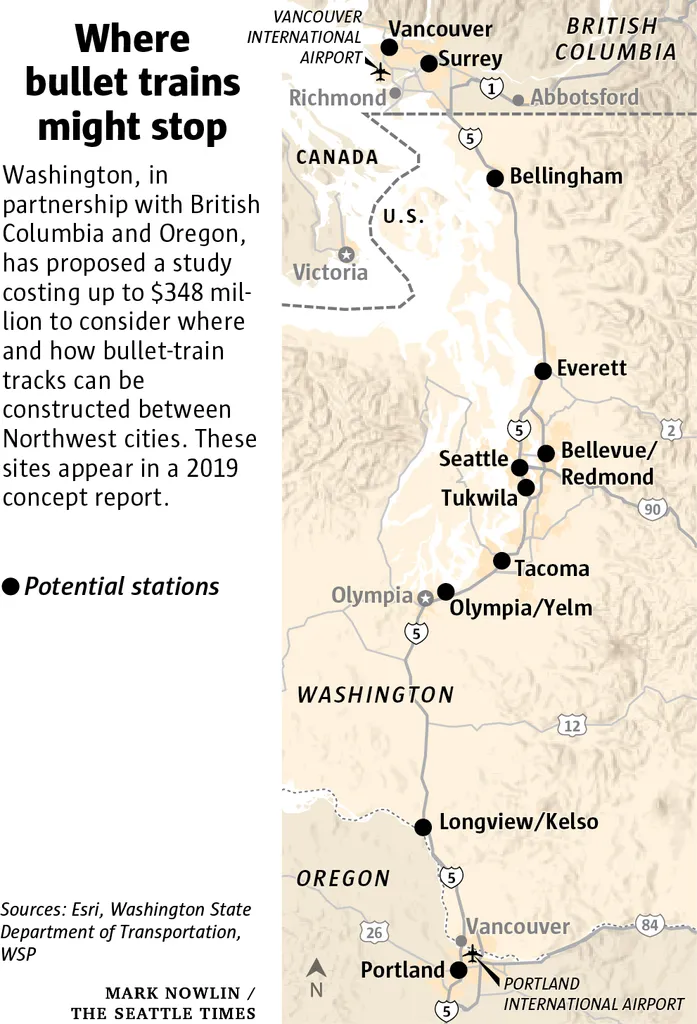
Seattle Times 2019 Concept Map of Pacific Northwest High-Speed Rail Stations
A 2019 concept map published by The Seattle Times (credit: Mark Nowlin) showing potential bullet train stations between Portland, Oregon and Vancouver, British Columbia, including stops at Seattle, Tacoma, Everett, Bellevue/Redmond, and other Northwest cities. The accompanying text notes Washington, in partnership with British Columbia and Oregon, proposed a study costing up to $348 million to plan high-speed rail infrastructure; sources cited are Esri, Washington State Department of Transportation, and WSP.