It’s all about construction permits
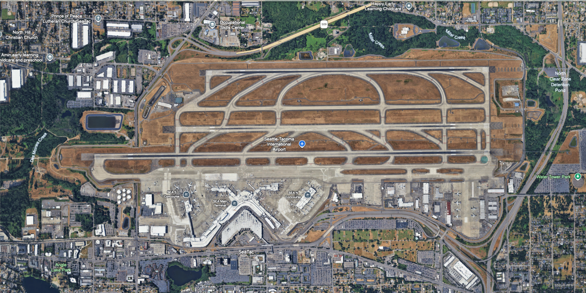
The Sustainable Airport Master Plan Near Term Projects Draft Environmental Impact Statement is a description of the effects of the largest expansion in airport history. But at bottom, it consists of thirty-one construction projects. What we find striking is the absence of detail on most of those projects. In most other contexts, almost all would merit their own EIS, including separate review of the buildings to be demolished and moved. This page describes some of the construction details we consider significant. Some terms you may not be familiar with, eg. ‘AAA’ and ‘APE’ are described below.
Loading map…
| ID | Description | Category | Purpose | Location | Construction_Requirements |
|---|---|---|---|---|---|
| A01 | Extension of parallel Taxiways A and B by approximately 1,800 feet. | Airside | Extend parallel Taxiways A and B by ~1,800 ft to provide access to the south end of Runway 16L/34R. | South airfield, south of S. 188th Street. | Relocate Taxiway S 310 ft south; relocate Runway 34R glideslope antenna, shelter, and PAPI; adjust glideslope angle; amend flight procedures; relocate a vehicle service road bridge over S. 188th St. Temporary wetland-buffer impacts 0.42 ac; WHPA impacts 4.58 ac. |
| A02 | Construction of Runway 16R/34L blast pads. | Airside | Expand Runway 16R/34L blast pads at both ends from 200x200 ft to 220x400 ft to meet current FAA standards. | Both ends of Runway 16R/34L (the east runway). | Temporary closure of Runway 16R/34L during active construction; NAVAID relocations. |
| A03 | Taxiway C/D reconfiguration and Runway Incursion Mitigation (RIM). | Airside | Correct non-standard taxiway geometry and address a runway incursion location by reconfiguring Taxiways C and D. | Central airfield. | Extend Taxiways C and D ~500 ft to intersect Taxilane A; remove pavement north of Taxiway C. |
| A04 | Relocation of portion of Taxiway B to meet standards. | Airside | Provide the FAA-required 500-ft runway/taxiway separation by relocating Taxiways A and B 100 ft east between Taxiways C and L. | Central airfield west of the terminal. | Extend Taxiways C, D, E, H, and K to the relocated Taxiway B; relocate NAVAIDs. Only partially meets the FAA standard; full-separation option was rejected because it would have required closing up to 20 gates. |
| A05 | Construction of a north holding pad (approximately 90,000 square feet). | Airside | Build a new ~90,000 sq ft hold pad for four aircraft to reduce taxiway and terminal congestion. | North airfield. | Standard hardstand construction; grouped operationally with T01/T02/A09. |
| A06 | Construction of a new high-speed exit for Runway 34L arrivals between Taxiways J and E. | Airside | Build a new high-speed exit between Taxiways J and E to allow more efficient runway use by arriving aircraft. | Runway 34L, between Taxiways J and E. | Relocate the multilateration remote unit; in-pavement centerline lights, edge lights, hold position markings, and signage. |
| A07 | Taxiway D extension of approximately 500 from Runway 16C/34C west to Taxiway T. | Airside | Extend Taxiway D ~500 ft west from Runway 16C/34C to Taxiway T. | Central airfield, west side. | Standard taxiway construction with in-pavement lighting, runway guard lights, and signage. |
| A08 | North cargo hardstand construction (approximately 360,000 square feet). | Airside | Build a new ~360,000 sq ft (1,200x300 ft) cargo hardstand accommodating five aircraft. | North Cargo area, east of Taxiway A. | Dependent on S07 (Westside Maintenance Campus), S08 (North Airline Support), and S09 (West Airline Support). Requires demolition of Bldg 161A (United Airlines Maintenance) and Bldg 161G (Port Maintenance). |
| A09 | Construction of a central hardstand (approximately 292,000 square feet). | Airside | Build a new ~292,000 sq ft hardstand for seven aircraft for hardstand operations and overnight parking. | North of Concourse D, east of the North Satellite. | Dependent on L01 (NAE relocation) and S05 (Triculator relocation). Requires bus service to reach hardstanded aircraft. Requires demolition of Bldg 170D (Guard Shack). |
| A10 | Taxiway fillets construction. | Airside | Bring taxiway fillets across the airfield up to current FAA standards. | Multiple taxiway intersections across the airfield. | Install new full-strength pavement panels and shoulders; edge lighting and signage. |
| T01 | Construction of a multi-level terminal concourse and aircraft apron (up to 19 gates). | Terminal | New multi-level concourse and apron with up to 19 additional gates. ~203,000 sq ft footprint, three levels totaling ~609,000 sq ft, plus elevated pedestrian walkway to the Main Terminal. | North of the North Satellite Concourse. | Requires displacement/demolition of Primary ARFF (Bldg 170A, → S02), Cargo 6 Swissport (Bldg 167A/167B, → C01), deicing tanks (→ S06), NAE (→ L01), and the fuel rack (→ S04). Sits at the top of a dependency chain that also draws in S08/S09. |
| T02 | Construction of an additional multi-level passenger terminal and parking garage. | Terminal | New multi-level passenger terminal ~575,000 sq ft (166,000 sq ft footprint) with basement baggage handling, baggage claim, interstitial commercial curbside, and departures level. Includes a new multi-level parking garage with ~1,350 spaces. | Across the NAE from the T01 concourse, displacing the Doug Fox Parking Lot. | Requires demolition of the Doug Fox Payment Building & Office (Bldgs 170B and 170C) and Gate Gourmet Flight Kitchen (Bldg 160D). Ties in with L03 (roads/curbside) and L02 (busway). Only DEIS-identified business displacement: Doug Fox Lot (~25 employees). |
| C01 | Cargo 4 warehouse construction to replace Cargo 6 warehouse demolished for T01. | Cargo | New ~80,000 sq ft cargo building (warehouse, office, truck terminals, parking) to replace the Cargo 6 warehouse demolished for T01. | Central cargo area (Cargo 4 South site). | Requires demolition of Bldg 166B (United Airlines Maintenance / Cargo 4S). Sequenced against T01. |
| C02 | Construction of a cargo warehouse north of State Route (SR) 518. | Cargo | New ~330,000 sq ft cargo warehouse (warehouse, office, truck terminals, parking). | Port's L-shaped parcel north of SR 518, in the City of SeaTac. | Tree removal, street demolition, extensive grading/excavation on steep-slope terrain. Ten phases; roof build-up 28 weeks; exterior/interior walls 24 weeks. Adjacent to residences along 26th Ave S and S. 152nd St. Ambient noise 66 dB (vs 76.5 dB inside airfield). Subject to ILA and SMC 15.700. |
| C03 | Cargo warehouse construction north of SR 518. | Cargo | Second cargo warehouse of ~90,000 sq ft (warehouse, office, truck terminals, parking). | Same L-shaped parcel north of SR 518. | Same steep-slope constraints as C02. Ten phases; excavation 8 wk; foundation 14 wk; roof build-up 8 wk; exterior/interior walls 10 wk. Same residential-adjacent noise profile as C02. |
| L01 | Relocation of North Airport Expressway southbound lanes for the construction A09 and T01. | Landside | New ~7,300 linear feet of NAE, widened from three to four lanes, to serve the Second Terminal and alleviate congestion. | Existing NAE corridor. | Replaces the section eliminated for A09 and T01. The cell phone lot is relocated to the main parking garage. L01 must be complete before A09 can proceed. |
| L02 | Elevated busway and stations at the Main Terminal, Second Terminal, and Rental Car Facility. | Landside | ~6,000 linear feet of elevated busway with three stations connecting Main Terminal, Second Terminal, and Rental Car Facility. | Eastern edge of Airport property, tying into existing bus routes. | Displaces the existing ground-transportation holding lot, which must be replaced by L05 north of SR 518. |
| L03 | Construction of a loop ramp and split-level curbsides for the Second Terminal. | Landside | New loop ramp from the southbound NAE to the new passenger terminal; connections to S. 160th St Loop, SR 518 EB on-ramp, and the northbound NAE. Split-level curbsides for arrivals, departures, and commercial vehicles. | Around T02. | Coordination with active NAE traffic; road closures and rerouting for several years per the alternatives analysis. |
| L04 | Northeast ground transportation center construction on north side of existing parking garage. | Landside | New ~255,000 sq ft five-level facility. Ground floor expands charter and cruise bus lot; level 2 is the elevated busway southern terminus (~87,000 sq ft); level 3 is passenger circulation and check-in (~64,000 sq ft) for busway and Link Light Rail transitions; levels 4-5 are office space (~52,000 sq ft each). | North side of the existing parking garage. | Ties into the existing garage and the Sound Transit station; substantial vertical construction above active facilities. |
| L05 | Relocation of the ground transportation holding lot displaced by L02 north of SR 518. | Landside | Replacement holding lot for ground-transportation drivers awaiting trips, replacing the lot displaced by L02. | North of SR 518, south of S. 144th St, on Port property in the City of SeaTac. | Steep-slope construction; adjacent to residential/industrial mix. Falls outside the AAA; subject to ILA and SMC (including SMC 15.700 critical areas). |
| L07 | Construction of employee parking garage north of SR 518. | Landside | New eight-story parking structure (one below grade, seven above) with ~3,500 stalls. Footprint ~3.3 acres. | North of SR 518, south of S. 144th St, immediately west of the existing North Employee Parking Lot, in the City of SeaTac. | Steep-slope construction; permanent wetland impact 0.02 ac (Wetland A) and temporary WHPA impact 0.31 ac. Absorbed the former L06 after scoping. Nearest residence ~2,000 ft. Subject to ILA and SMC. |
| S01 | Fuel farm expansion (four new settling tanks and one blending tank). | Support | Expand fuel storage capacity. Adds 4 new settling tanks (~10M gal), ~500,000 gal blending tank, ~100,000 gal SAF receipt tank, additional piping, expanded spill containment dike, and a new truck fuel rack for SAF delivery. | Former south employee parking lot, south airfield. | Must comply with WAC 173-180-330/340 (Class 1 Facility seismic standards). Permanent wetland impact 0.21 ac (all of Wetland E1); mitigation must occur on other Port property or at Auburn mitigation site. Temporary 0.07 ac impact to East Fork Des Moines Creek. NWP planned; may exceed 0.5 ac threshold. |
| S02 | Relocation of Aircraft Rescue and Firefighting Facility for construction of T01. | Support | Relocate the Primary ARFF station displaced by T01. ~50,000 sq ft. | South airfield, between Runway 16R/34L and Runway 16C/34C. | Requires demolition of Bldg 188WB (PACCAR); PACCAR has elected to relocate to another regional airport by end of 2026. Must be functional before T01 can proceed. |
| S03 | Construction of secondary ARFF facility. | Support | ~10,000 sq ft secondary ARFF providing ambulatory response to terminals/concourses, ramp fuel and fire response, and backup emergency response to the airfield. | Integrated within the T01 concourse at the southeast end, with airside and landside access. | Built as part of T01; sequenced with terminal construction. |
| S04 | Relocation of the fuel rack from Cargo 6 to Cargo 3 for construction of T01. | Support | Move the fuel rack (where fuel trucks refill) from Cargo 6 to Cargo 3 to clear the T01 site. | Cargo 3 area. | Enabling project for T01. Relocation of active fueling infrastructure. |
| S05 | Triculator relocation to north cargo area for construction of A09. | Support | Relocate the triculator (transfers aircraft waste to the sewer system) from east of the existing ARFF to the North Cargo area to clear the A09 site. | North Cargo area. | Enabling project for A09. Relocation of active sanitary infrastructure. |
| S06 | Relocation of deicing tanks to a northern and southern location. | Support | Relocate deicing-fluid tanks from Cargo 6 and Cargo 7 to a northern site and a southern site to clear the T01 footprint. Each site gets containment, two tanks (Type I and Type IV), and a blending station. | Two new sites: one north, one south of the current locations. | Enabling project for T01. Glycol/hazmat handling; secondary containment construction. |
| S07 | Construction of westside maintenance campus. | Support | Relocate the Port's Aviation Maintenance Facility from its current site (needed for A08) and co-locate related functions. Includes vehicle fuel rack, airfield deicer storage, snow equipment storage, and multi-bay maintenance buildings. | Vacant west-side land, west of SR 509; residences ~1/4 mile west of SR 509. | Reconstruct existing S. 168th St access; new access road from S. 157th Pl. Permanent Miller Creek impact 0.01 ac plus 0.07 ac stream buffer; temporary 0.01 ac plus 0.20 ac buffer; |
| S08 | Airline support building construction in north cargo for construction of T01 and A08. | Support | ~15,000 sq ft airline-support building to house airline support functions displaced by T01 and A08. | Northeast corner of the North Cargo area. | Enabling project for both T01 and A08; must exist before either can eliminate the current functions. |
| S09 | Expansion of the AMB/AFCO III building to replace displaced airline support facilities. | Support | ~25,700 sq ft expansion west of the existing AMB/AFCO III building (used for cargo operations) to accommodate maintenance functions displaced by T01 and A08. | Adjacent to existing AMB/AFCO III building. | Building expansion abutting active cargo operations; enabling project for T01 and A08. |
| S10 | Construction of centralized receiving and distribution center north of SR 518. | Support | ~55,000 sq ft warehouse, office, truck-terminal, and parking facility to consolidate deliveries to SEA dining and retail concessionaires. | North of SR 518, south of S. 144th St, on Port property in the City of SeaTac. | Steep-slope construction; between existing industrial/commercial buildings. Outside the AAA; subject to ILA and SMC. |
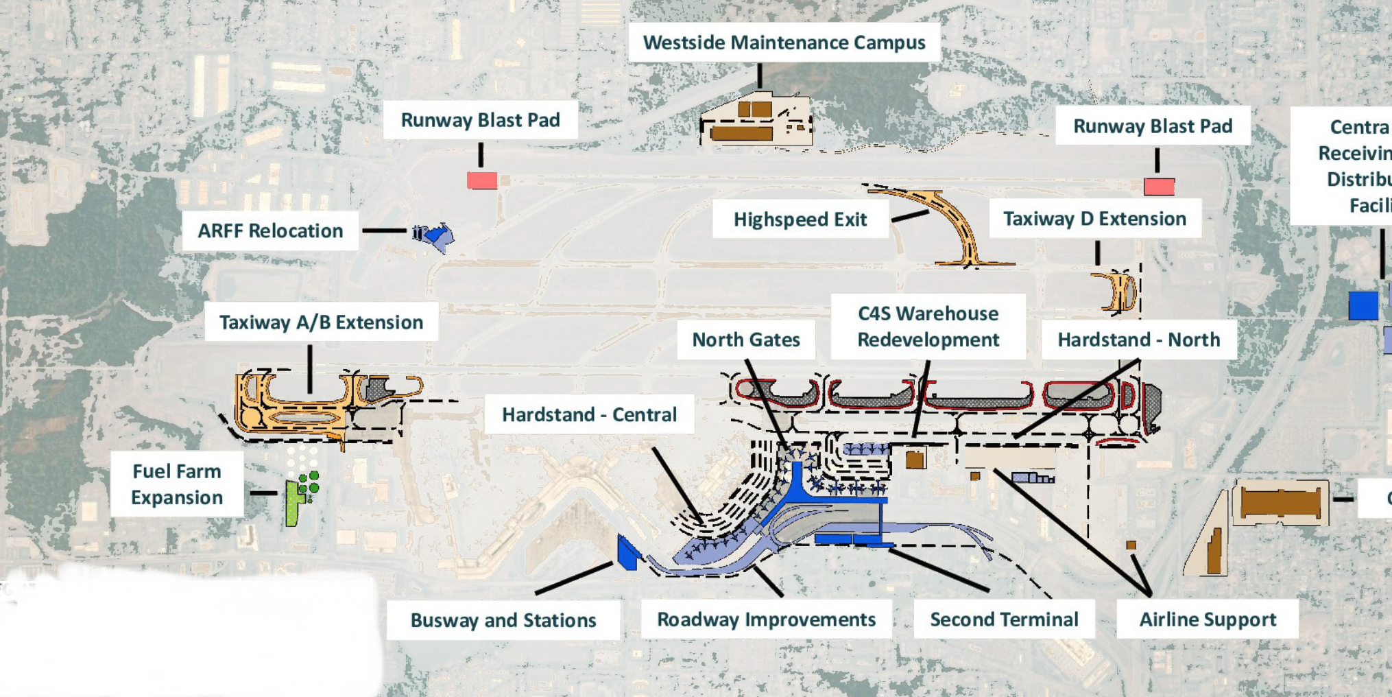
Overall Program Support
The DEIS lists the following as “Overall Program Support” — not part of the 31 but necessary for them:
- Expansion of existing stormwater / industrial wastewater infrastructure.
- New stormwater management facilities (including Miller Creek detention pond, Pond F, Pond M, SDS4 pond).
- Conversion of two existing storm drainage vaults (3 and 3A) to industrial wastewater vaults.
- Utility connections: sewer, water, natural gas, fuel, information/communication technology.
- Central mechanical plant upgrades.
- Construction staging on Port property outside sensitive areas.
Cross-Project Dependencies at a Glance
The NTPs are described as 31 separate projects but many cannot proceed independently. The primary dependency chains in the DEIS record:
- **T01 (North Gates)** cannot proceed until S02 (Primary ARFF relocation), C01 (Cargo 4 South redevelopment as Cargo 6 replacement), S04 (fuel rack relocation), S06 (deicing tank relocation), and L01 (NAE relocation) are complete. S08 and S09 also serve as displacement targets for T01.
- **A08 (North Cargo Hardstand)** cannot proceed until S07 (Westside Maintenance Campus), S08 (North Airline Support), and S09 (West Airline Support) are complete.
- **A09 (Central Hardstand)** cannot proceed until L01 (NAE relocation) and S05 (Triculator relocation) are complete.
- **T02 (Second Terminal)** requires L03 (roads/curbside) and connects to L02 (busway) and L04 (NE GTC).
- **L02 (Busway)** displaces the existing GT holding lot, which must be replaced by L05 north of SR 518.
Permitting outside the AAA
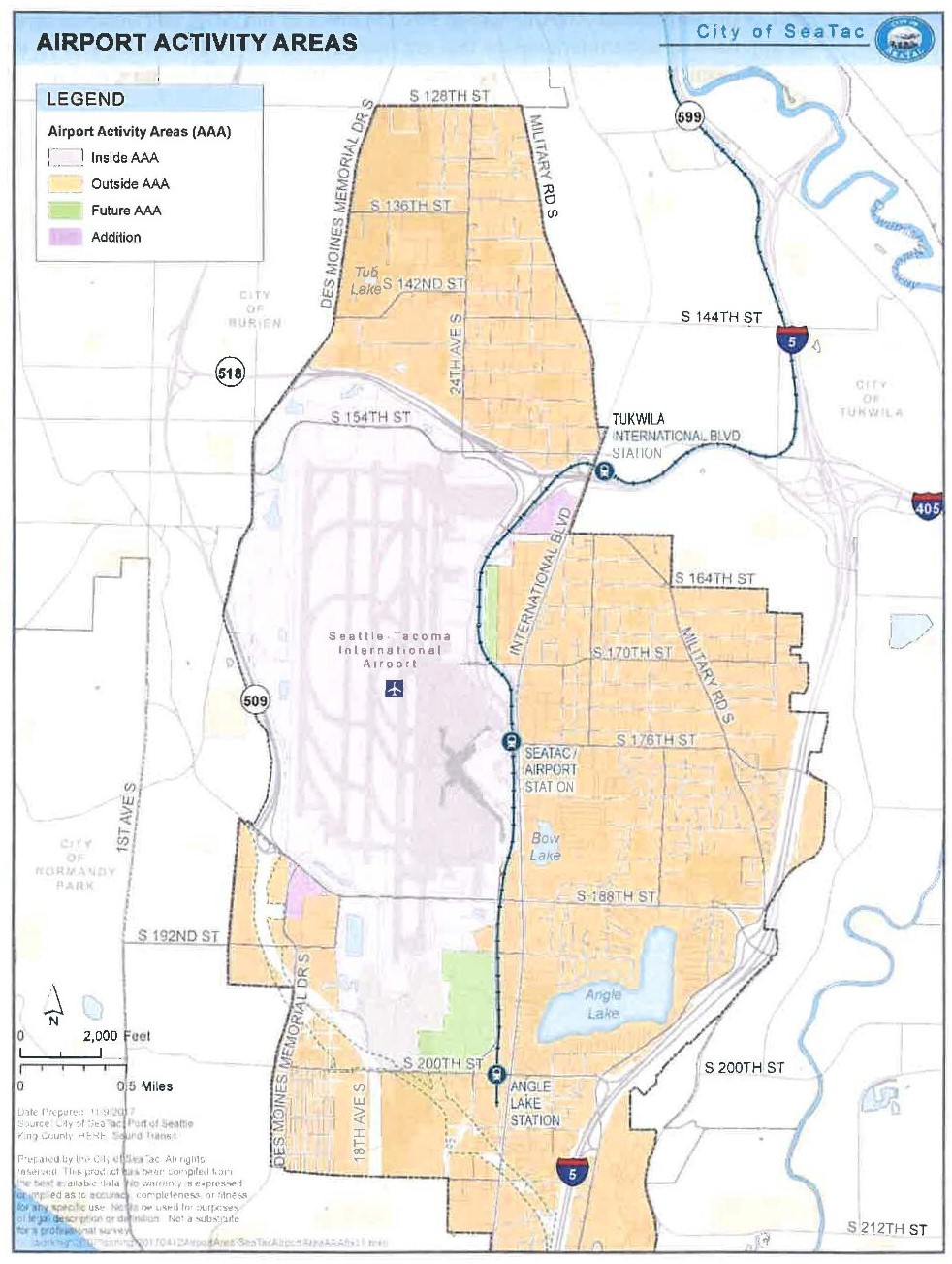
The City of SeaTac has an ongoing ILA with the Port of Seattle . In exchange for both annual and project-based compensation, this allows the Port to self-permit on projects inside the Airport Activity Areas (AAA) –the land zoned as essential for airport operations.
This area will expand slightly with the SAMP NTP (see green area at lower right).
| NTP | Name | Footprint | Location within SeaTac | Site now | Nearest residential | Regulatory notes | |
|---|---|---|---|---|---|---|---|
| C02 | Offsite Cargo – Phase 1 | ~330,000 sq ft warehouse + office, truck terminals, parking | Port's "L-shaped parcel" north of SR 518, south of S. 144th St | Undeveloped; treed; steep slopes per City of SeaTac mapping | Residences along 26th Ave S and S. 152nd St | ILA + SMC 15.700 (critical areas); ambient noise 66 dB (vs 76.5 dB inside airfield) so construction noise is much more noticeable | |
| C03 | Offsite Cargo – Phase 2 | ~90,000 sq ft warehouse + office, truck terminals, parking | Same L-shaped parcel as C02 | Same undeveloped/steep-slope profile | Same as C02 | Same ILA + SMC framework | |
| L05 | North GT Holding Lot | Surface holding lot for rideshare/taxi/shuttle drivers | North of SR 518, south of S. 144th St | Port property between industrial/commercial buildings; steep slope terrain | Limited visibility from sensitive receptors per Ch 4 § 4.3.13 | Outside AAA; ILA + SMC apply | |
| L07 | Employee Parking Structure | 8-story (1 below grade, 7 above), ~3,500 stalls, 3.3-acre footprint | North of SR 518, south of S. 144th St, immediately west of existing North Employee Parking Lot (near S. 142nd St & 24th Ave S) | Undeveloped; Wetland A (0.11 acre) partially on-site; wellhead protection area | Nearest residence ~2,000 ft with intervening topography and vegetation | Absorbed the dropped L06; permanent 0.02-acre wetland impact; NWP planned | |
| S10 | Centralized Receiving and Distribution Center (CRDC) | ~55,000 sq ft warehouse, office, truck terminals, parking | North of SR 518, south of S. 144th St | Between existing industrial/commercial buildings; steep slope | Limited visibility from sensitive receptors | Outside AAA; ILA + SMC apply |
Demolition, man
In addition to all the construction, a lot of buildings are being removed. Normally, each building would require a separate SEPA demolition permit and the environmental consequences of each removal would be subject to review.
| Building # | Name | NTP demolishing it | Where |
|---|---|---|---|
| 160D | Gate Gourmet Flight Kitchen | T02 | Near Doug Fox area (built mid-late 1970s) |
| 161A | United Airlines Maintenance | A08 | 2230 S 161st St (per H-45 contaminated site table) |
| 161E | Cargo 4E | (implied C01) | S 161st St vicinity |
| 161G | Port Maintenance Building | A08 | S 161st St vicinity |
| 166B | United Airlines Maintenance / Cargo 4S | C01 | Built 1969 |
| 167A / 167B | Cargo 6 Swissport | T01 | Built 1977, addition 2000 |
| 170A | Primary ARFF | T01 | Built 1978, fire engine bays on SW side |
| 170B | Doug Fox Payment Building | T02 | Built 2014 |
| 170C | Doug Fox Office | T02 | Built 2014 |
| 170D | Guard Shack | A09 | Built 2006 |
| 170W | Port Westside Field Offices | S07 | Westside of airport |
| 188WB | PACCAR Building | S02 | Off Starling Drive (per Ch. 4.3.11) |
Appendix F (Hazardous Materials) names all 12 buildings being demolished by their Port building numbers — which map to specific locations at SEA.
- Appendix F Exhibit 2 — shows the 11 contaminated sites within the limits of disturbance. Contains H-45, H-49, H-53 addresses.
- Appendix M Figures 1, 1-6a through 1-6d, 2a and 2b — show all NTP footprints (including demolition areas) plotted against parcel boundaries, streets, streams, and wetlands. These are the most useful geographic maps in the record.
- Chapter 4 Exhibit 4.3.6-1 — “Contaminated Sites Within the Limits of Disturbance.”
- Chapter 1 Table 1.3-1 lists demolitions by common name only, no addresses.
- Appendix F §4.2.2 (building numbers + descriptions).
- Appendix F Table 3 (three street addresses: 2230 S 161st, 17200 Air Cargo Rd, 2350 S 190th St).
- Appendix M Figures for geographic content.