I understand that you will never share my information with anyone, you will only use it to keep me updated on relevant events and that I may unsubscribe at any time.
Since 2016, working to obtain justice for everyone living under the flight path.
Less Noise. Cleaner Air. Better Public Health. Compensation.
Everything you think you know about the airport is wrong.
Sea-Tac Communities Plan – Planning Maps
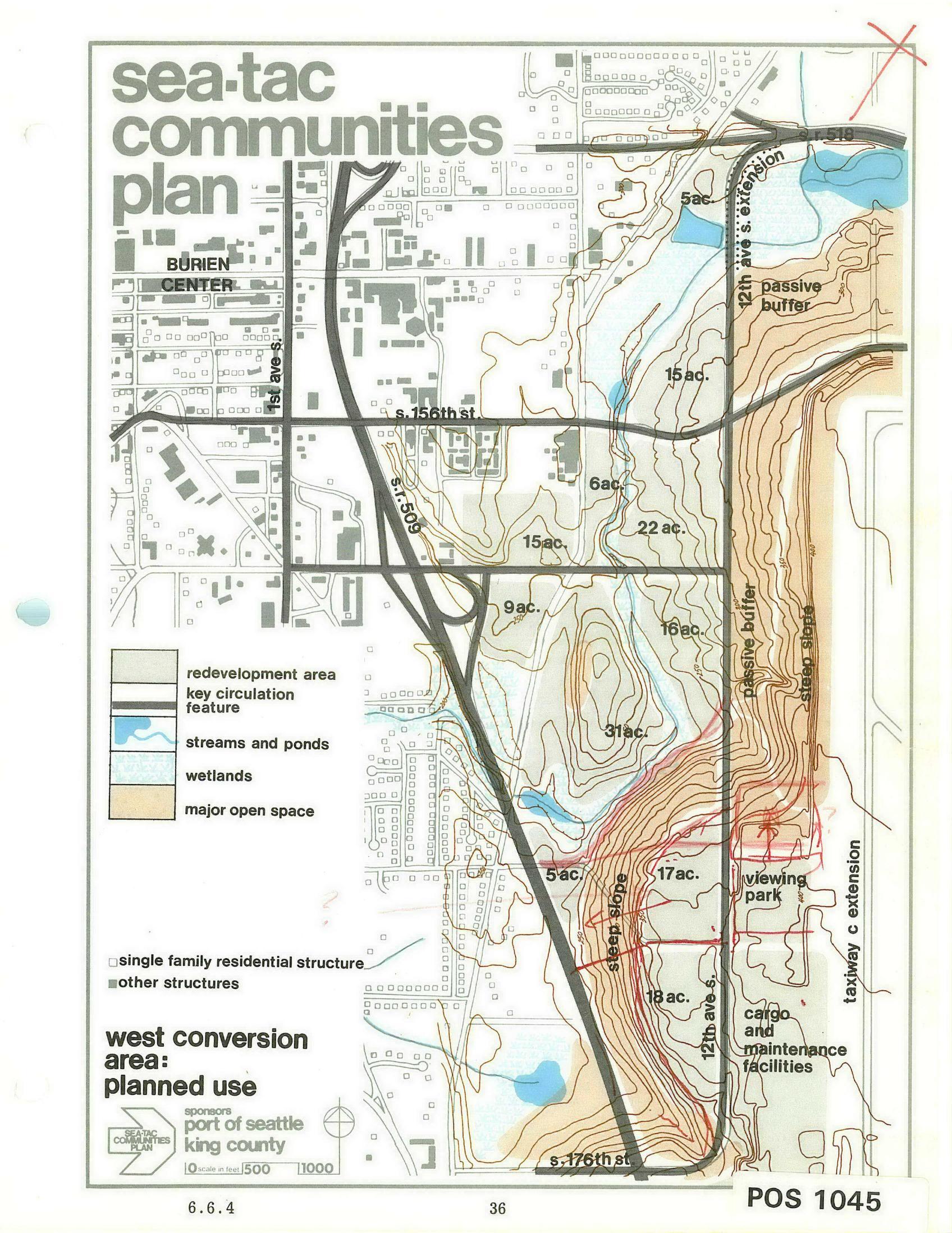
This is page 36 of the Sea-Tac Communities Plan, document reference POS 1045, map section 6.6.4, titled 'West Conversion Area: Planned Use.' Sponsored by the Port of Seattle and King County, the map shows planned land uses adjacent to Seattle-Tacoma International Airport including redevelopment areas, streams and wetlands, major open space, passive buffers, steep slopes, a proposed viewing park, cargo and maintenance facilities, and a taxiway C extension, with acreages labeled throughout the study area near Burien Center and S. 156th–S. 176th Streets.
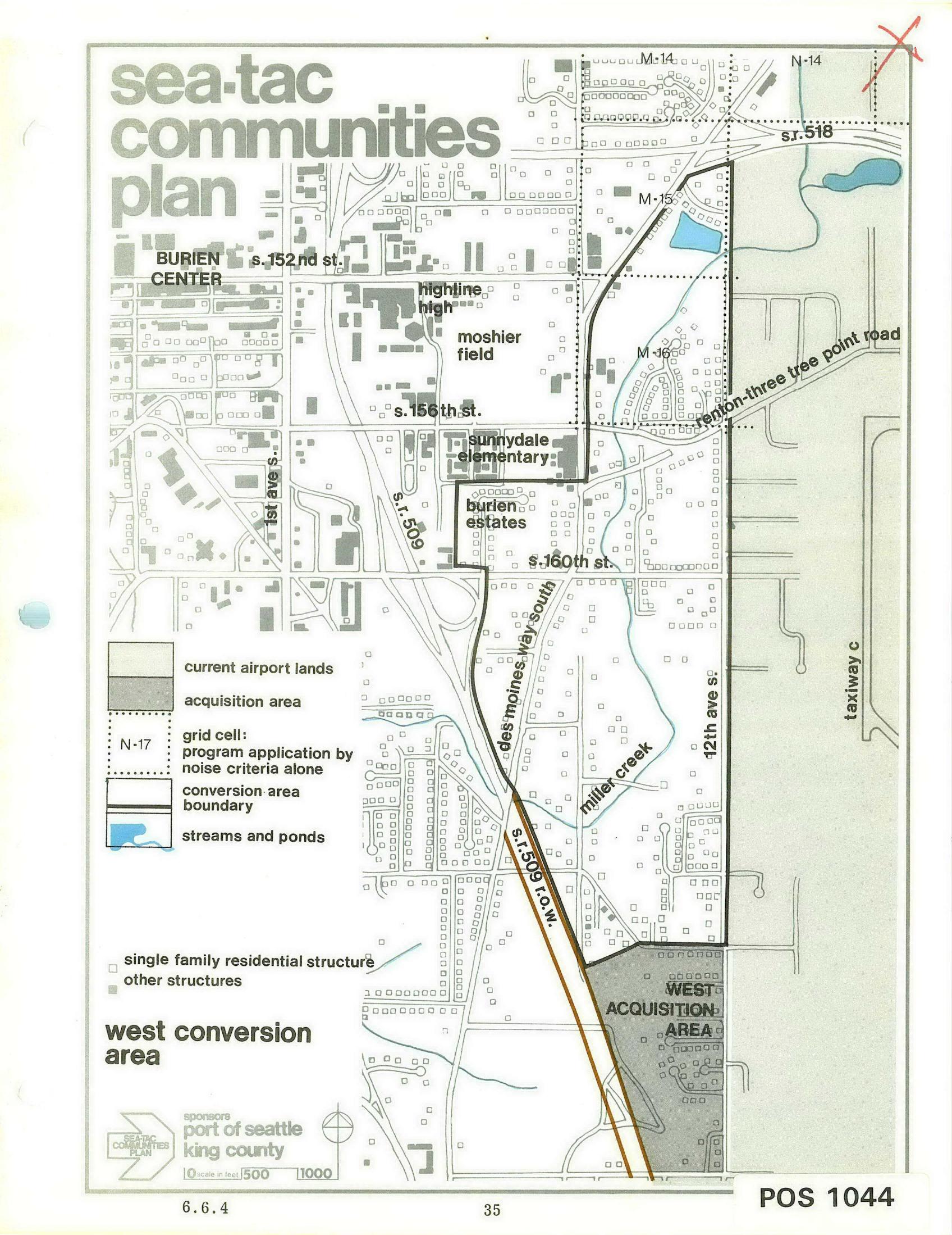
Planning map labeled 'Sea-Tac Communities Plan – West Conversion Area,' sponsored by the Port of Seattle and King County, showing the west conversion area boundary, current airport lands, acquisition areas, grid cells subject to noise criteria, streams and ponds, and named landmarks including Burien Center, Highline High School, Moshier Field, Sunnydale Elementary, and Burien Estates. Document reference number POS 1044 appears at lower right, and the map scale and section number 6.6.4 are noted at bottom.
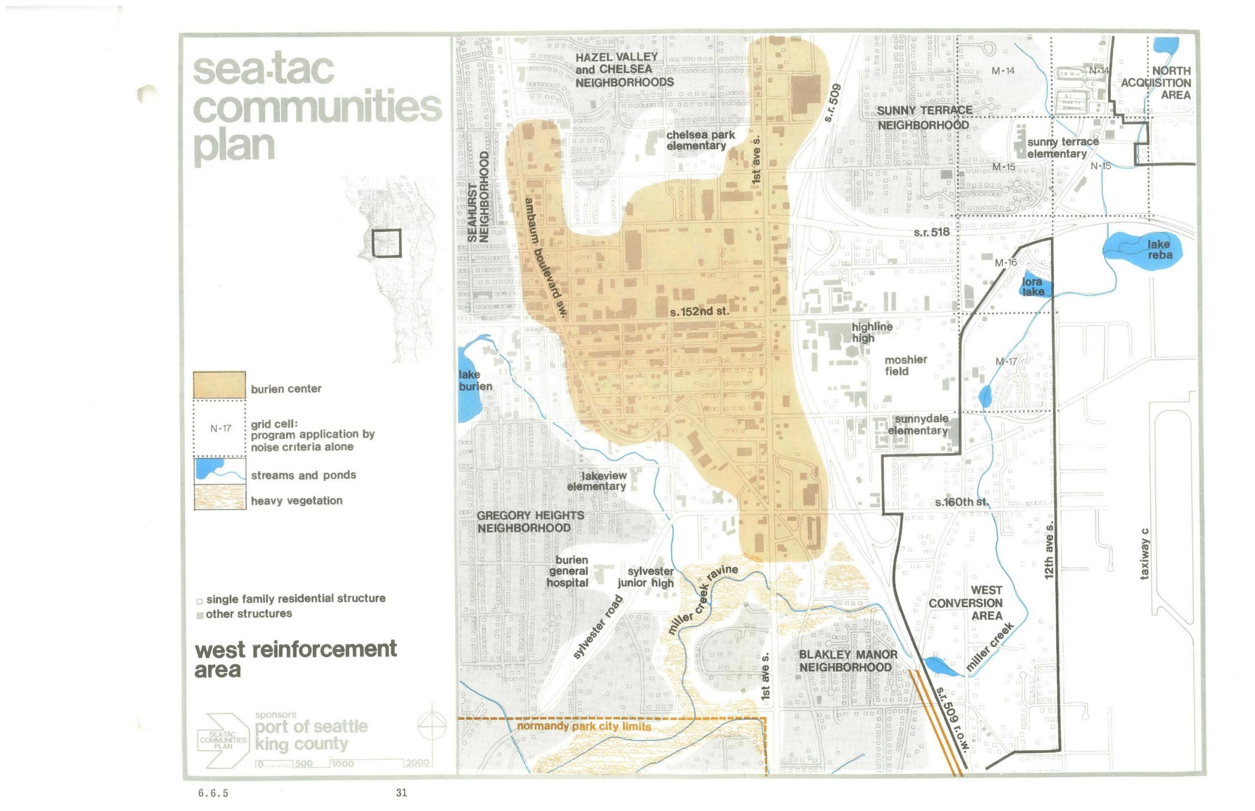
A planning map from the Sea-Tac Communities Plan, sponsored by the Port of Seattle and King County, depicting the West Reinforcement Area including the Burien Center, surrounding neighborhoods (Seahurst, Hazel Valley, Chelsea, Gregory Heights, Sunny Terrace, Blakley Manor), schools, waterways, and adjacent land-use zones such as the North Acquisition Area and West Conversion Area. The map uses color coding and grid cells to indicate noise-based program application areas, streams, ponds, and heavy vegetation, with key landmarks including Highline High School, Lake Burien, and S.R. 518.
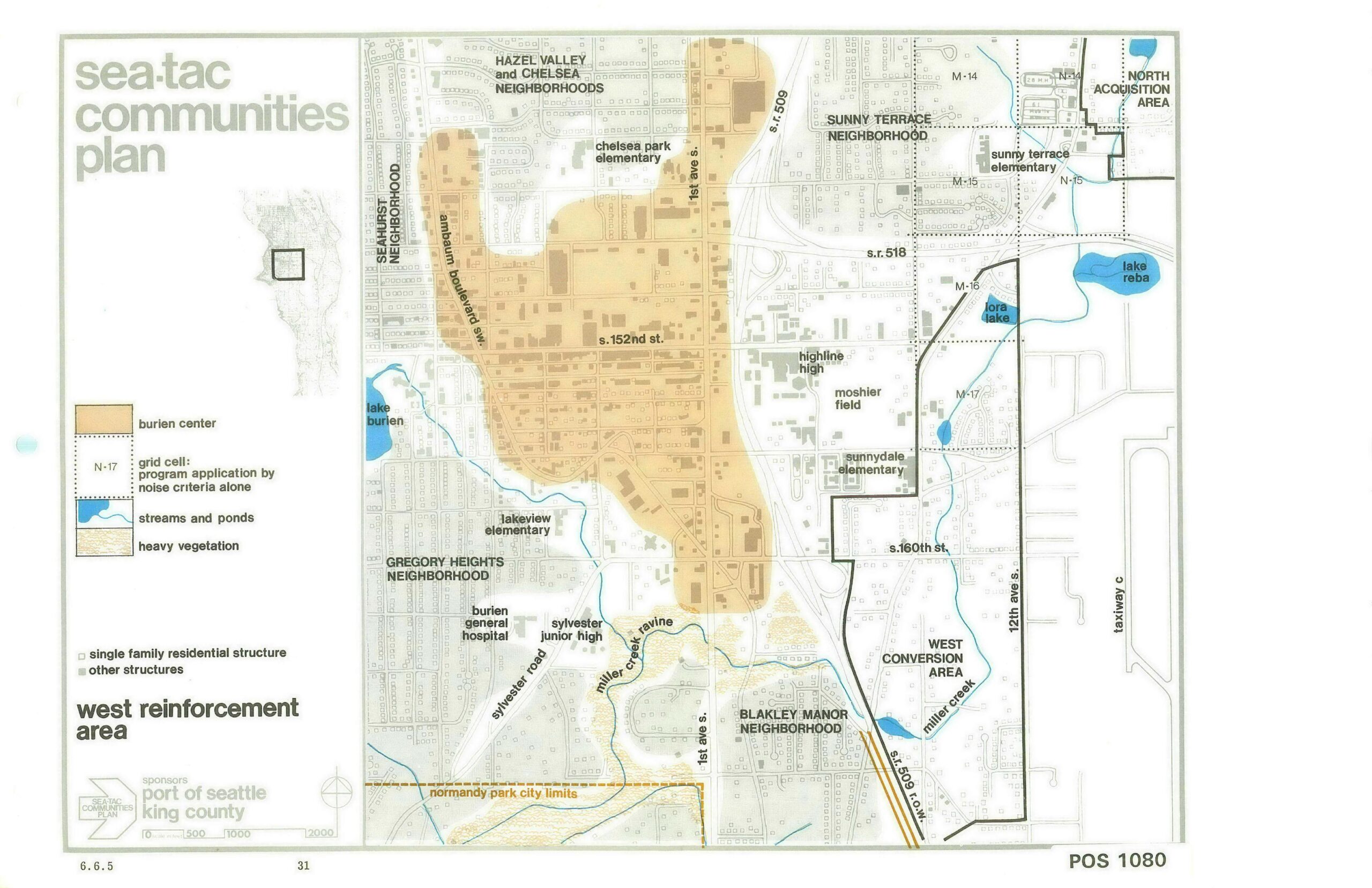
This is map 6.6.5 (page 31, document reference POS 1080) from the Sea-Tac Communities Plan, sponsored by the Port of Seattle and King County. It depicts the West Reinforcement Area, showing neighborhoods including Hazel Valley and Chelsea, Seahurst, Gregory Heights, Sunny Terrace, and Blakley Manor, with grid cells indicating noise-criteria program application areas, the Burien Center boundary, streams and ponds, and key landmarks such as Highline High School, Burien General Hospital, and Lora Lake.
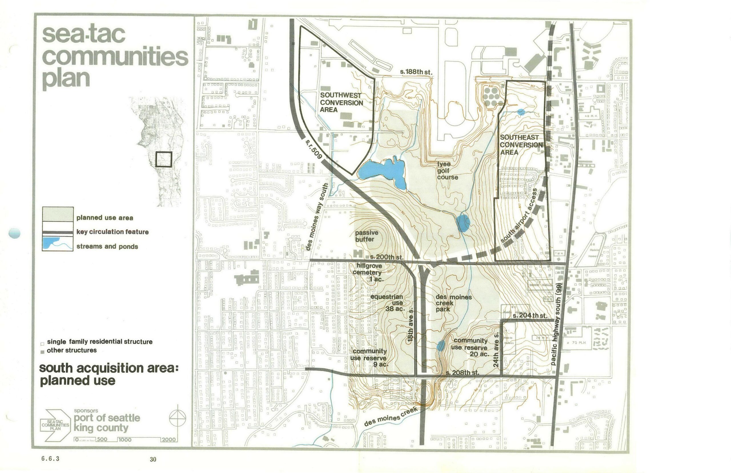
A planning map from the Sea-Tac Communities Plan, sponsored by the Port of Seattle and King County, showing the south acquisition area's planned land uses including the Southwest and Southeast Conversion Areas, Tyee Golf Course, Des Moines Creek Park, equestrian use (38 ac.), community use reserves, Hillgrove Cemetery, and a passive buffer zone. Key circulation features including SR-509, Des Moines Way South, and Pacific Highway South (99) are delineated, with streams and ponds shown in blue.
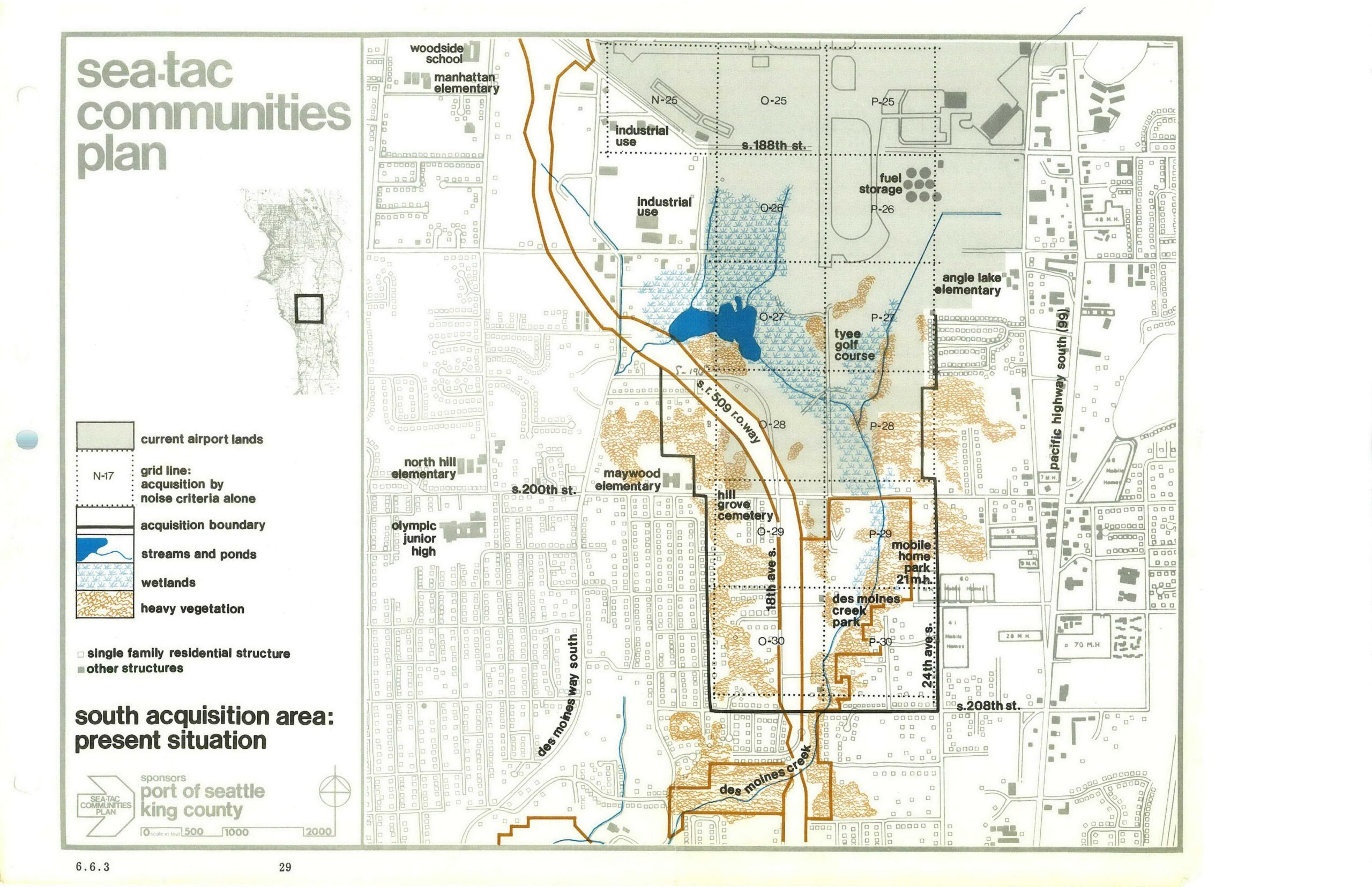
This planning map, page 29 (figure 6.6.3) of the Sea-Tac Communities Plan sponsored by the Port of Seattle and King County, depicts the south acquisition area around Seattle-Tacoma International Airport, showing current airport lands, acquisition boundaries, grid lines for noise-criteria acquisition, streams, ponds, wetlands, heavy vegetation, and key landmarks including Tyee Golf Course, Hill Grove Cemetery, Des Moines Creek Park, and several schools along Pacific Highway South and Des Moines Way South.
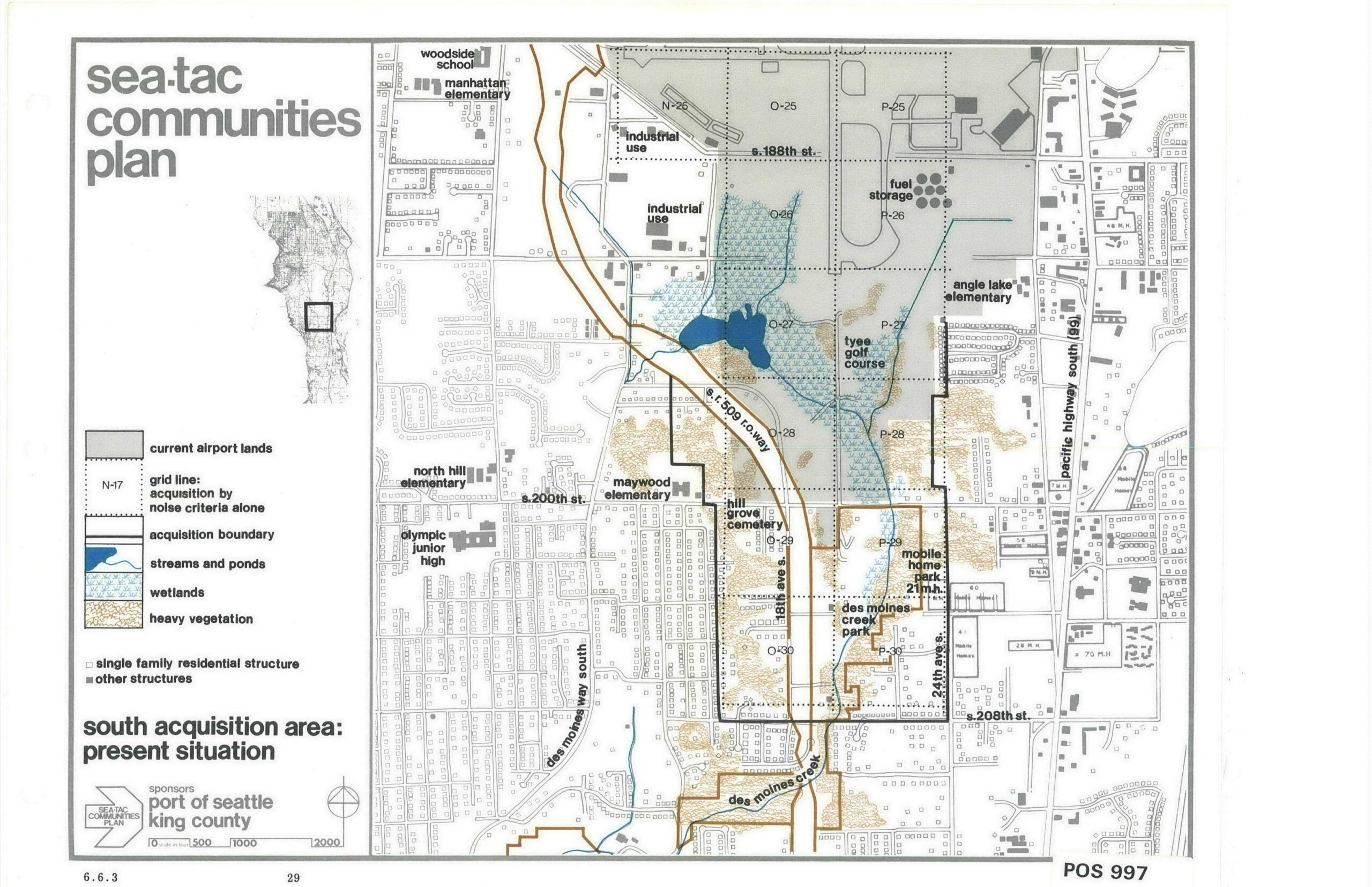
This is page 29, map 6.6.3 from the Sea-Tac Communities Plan (document POS 997), sponsored by the Port of Seattle and King County. The map depicts the south acquisition area around Seattle-Tacoma International Airport, showing current airport lands, acquisition boundaries based on noise criteria, streams, wetlands, heavy vegetation, and named landmarks including Tyee Golf Course, Hill Grove Cemetery, Des Moines Creek Park, and several elementary schools.
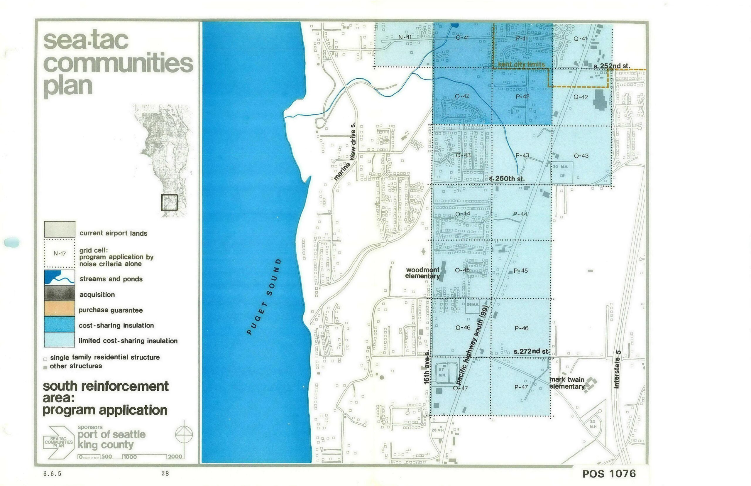
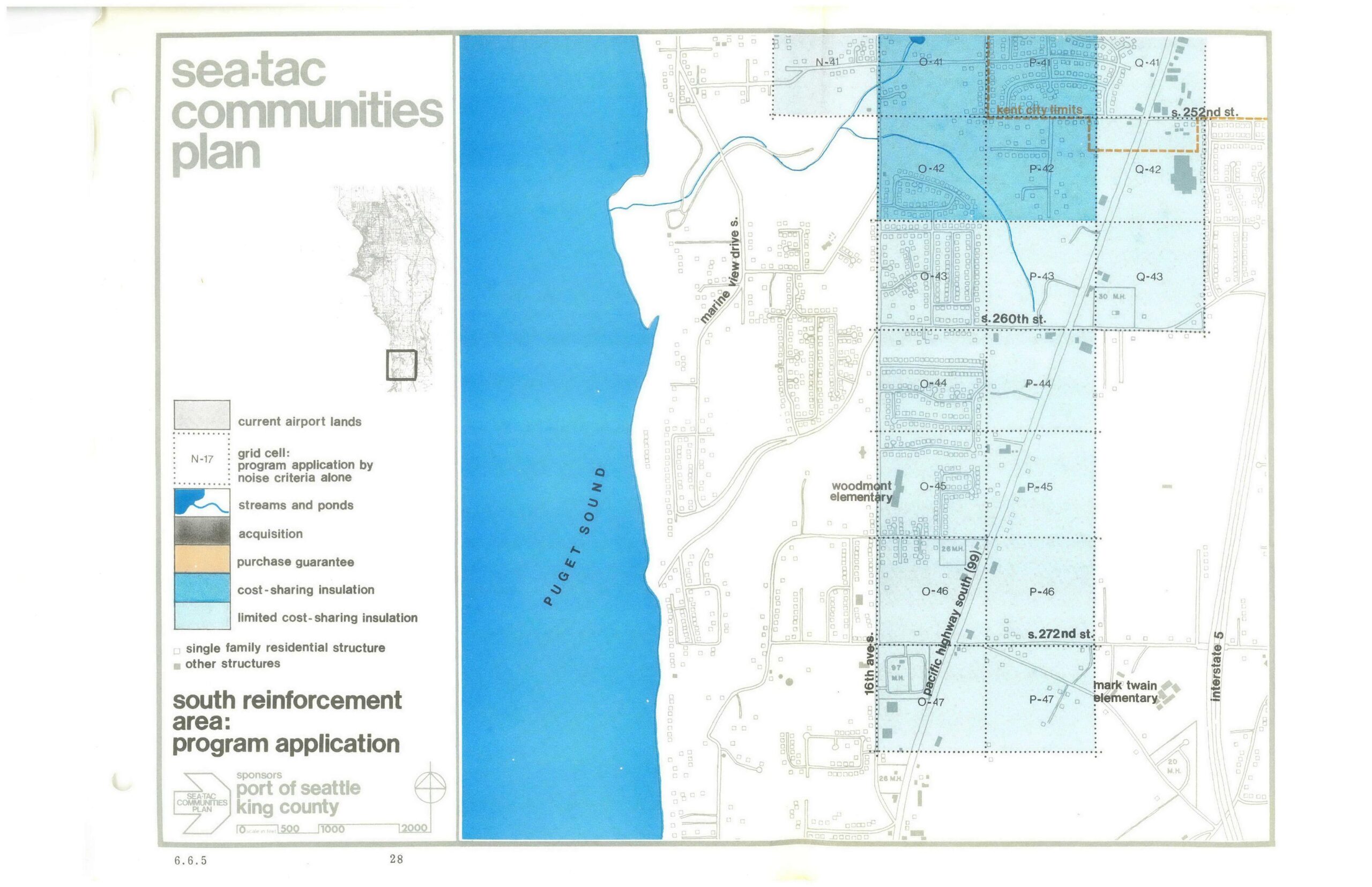
This map, labeled 'Sea-Tac Communities Plan – South Reinforcement Area: Program Application' (document reference POS 1076, page 28, section 6.6.5), was sponsored by the Port of Seattle and King County. It depicts grid cells O-41 through Q-47 in the area west of Interstate 5 and east of Puget Sound, color-coded to show noise-mitigation program designations including cost-sharing insulation, limited cost-sharing insulation, acquisition, and purchase guarantee zones, with landmarks including Woodmont Elementary, Mark Twain Elementary, Pacific Highway South (SR 99), and S. 252nd through S. 272nd Streets.
A planning map from the Sea-Tac Communities Plan, sponsored by the Port of Seattle and King County, showing the South Reinforcement Area's program application for noise mitigation. The map depicts grid cells in the area bounded roughly by S. 252nd St. to S. 272nd St. and Marine View Drive S. to Interstate 5, color-coded to indicate acquisition, purchase guarantee, cost-sharing insulation, and limited cost-sharing insulation zones, with landmarks including Woodmont Elementary, Mark Twain Elementary, and the Kent City Limits noted.
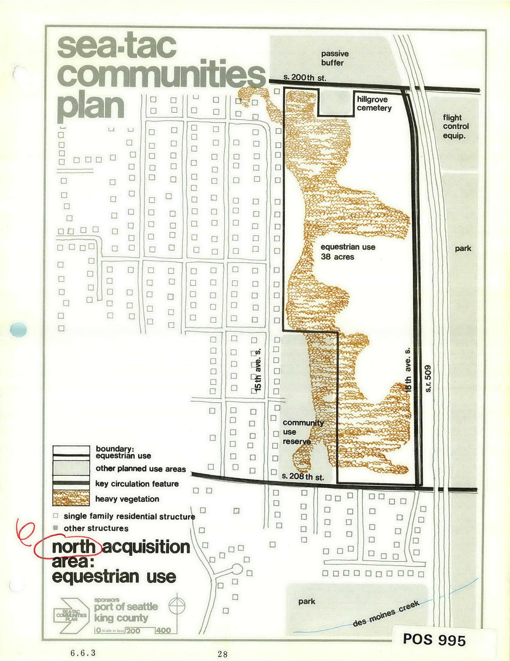
A planning map labeled 'POS 995' from the Sea-Tac Communities Plan, sponsored by the Port of Seattle and King County, showing the north acquisition area designated for equestrian use (38 acres) between S. 200th St. and S. 208th St., bounded by 15th Ave. S. and 16th Ave. S./S.R. 509. The map identifies land uses including Hillgrove Cemetery, a passive buffer, flight control equipment area, community use reserve, heavy vegetation, and adjacent parks including one near Des Moines Creek.
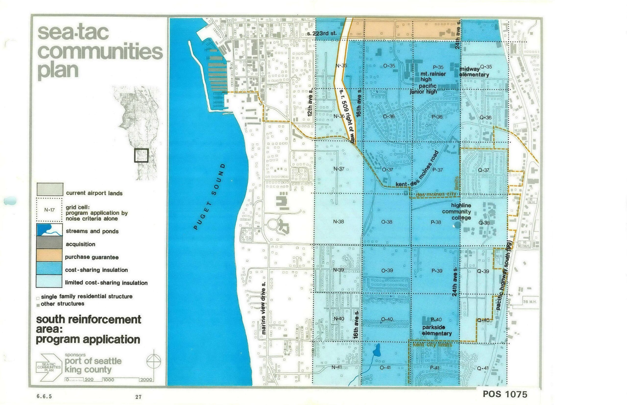
A planning map from the Sea-Tac Communities Plan, sponsored by the Port of Seattle and King County, showing the south reinforcement area and its program applications including cost-sharing insulation, acquisition, purchase guarantee, and limited cost-sharing insulation zones. The map (document reference 6.6.5, page 27, POS 1075) covers grid cells N/O/P/Q rows 35–41 along Puget Sound, identifying landmarks such as Mt. Rainier High, Pacific Junior High, Midway Elementary, Highline Community College, and Parkside Elementary.
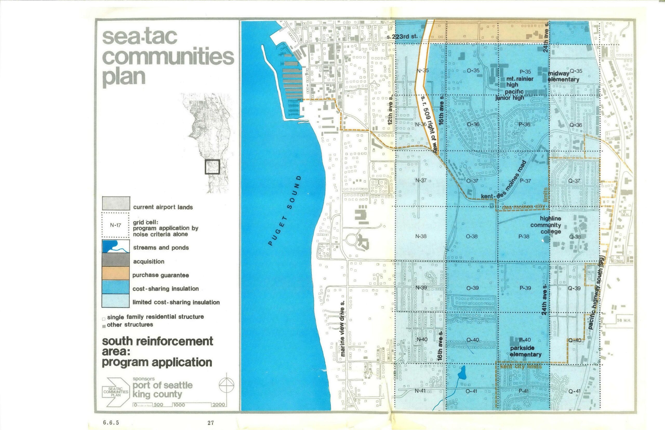
This is page 27 (section 6.6.5) of the Sea-Tac Communities Plan, sponsored by the Port of Seattle and King County, showing the South Reinforcement Area program application map. The map depicts grid cells across the area east of Puget Sound (along Marine View Drive S., 12th, 16th, and 24th Ave S., and the Kent-Des Moines Road corridor) color-coded by noise-mitigation program type: cost-sharing insulation, limited cost-sharing insulation, purchase guarantee, and acquisition, with landmarks including Mt. Rainier High, Pacific Junior High, Midway Elementary, Highline Community College, and Parkside Elementary noted.
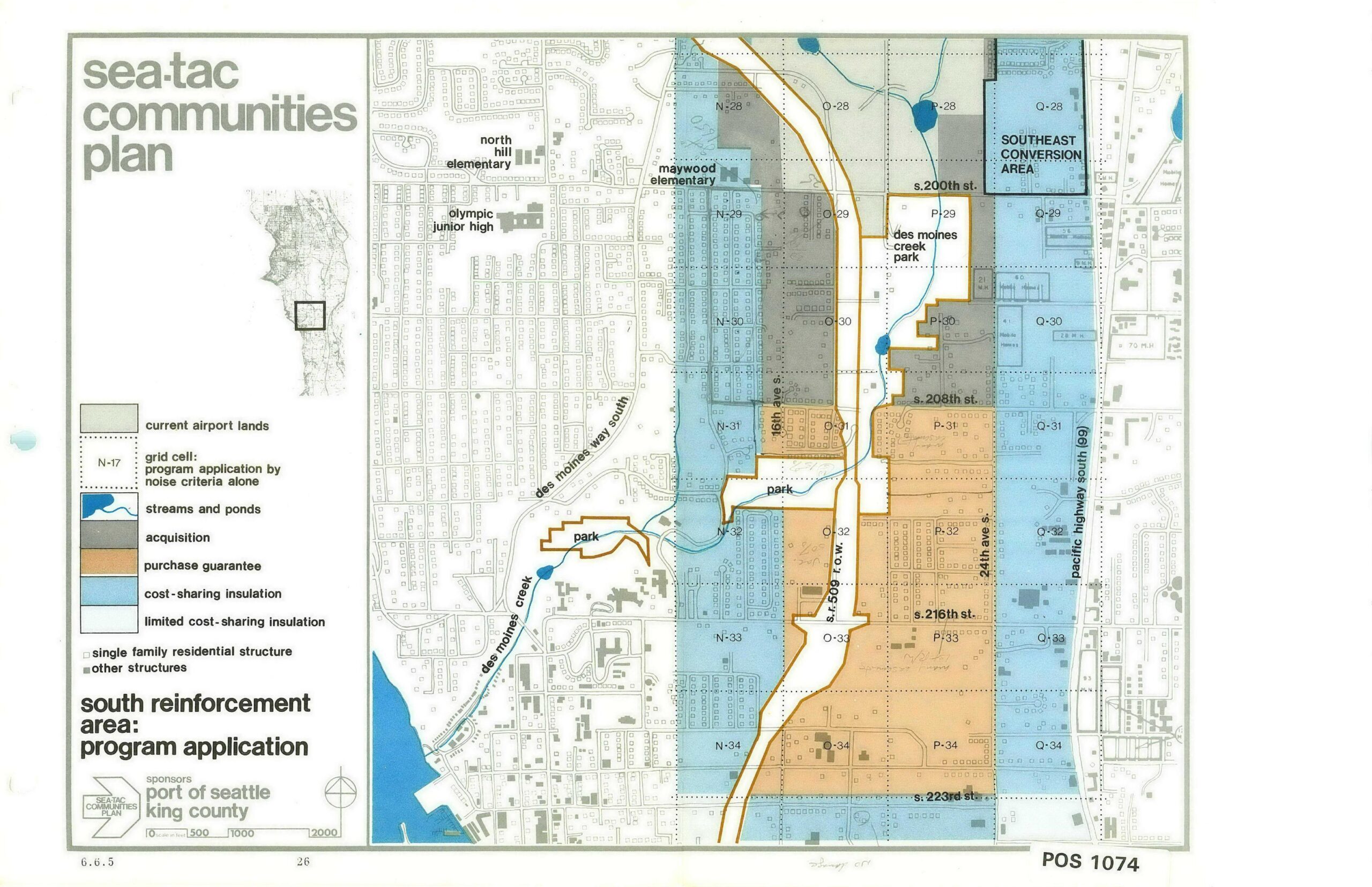
This planning map, document number POS 1074 (sheet 6.6.5, page 26), was produced for the Sea-Tac Communities Plan and sponsored by the Port of Seattle and King County. It depicts the South Reinforcement Area program application, showing grid cells color-coded by noise-mitigation program type—including acquisition, purchase guarantee, cost-sharing insulation, and limited cost-sharing insulation—across the area roughly bounded by S. 200th St. to the north and S. 223rd St. to the south, with landmarks such as Des Moines Creek Park, Maywood Elementary, and Pacific Highway South (SR 99) labeled.
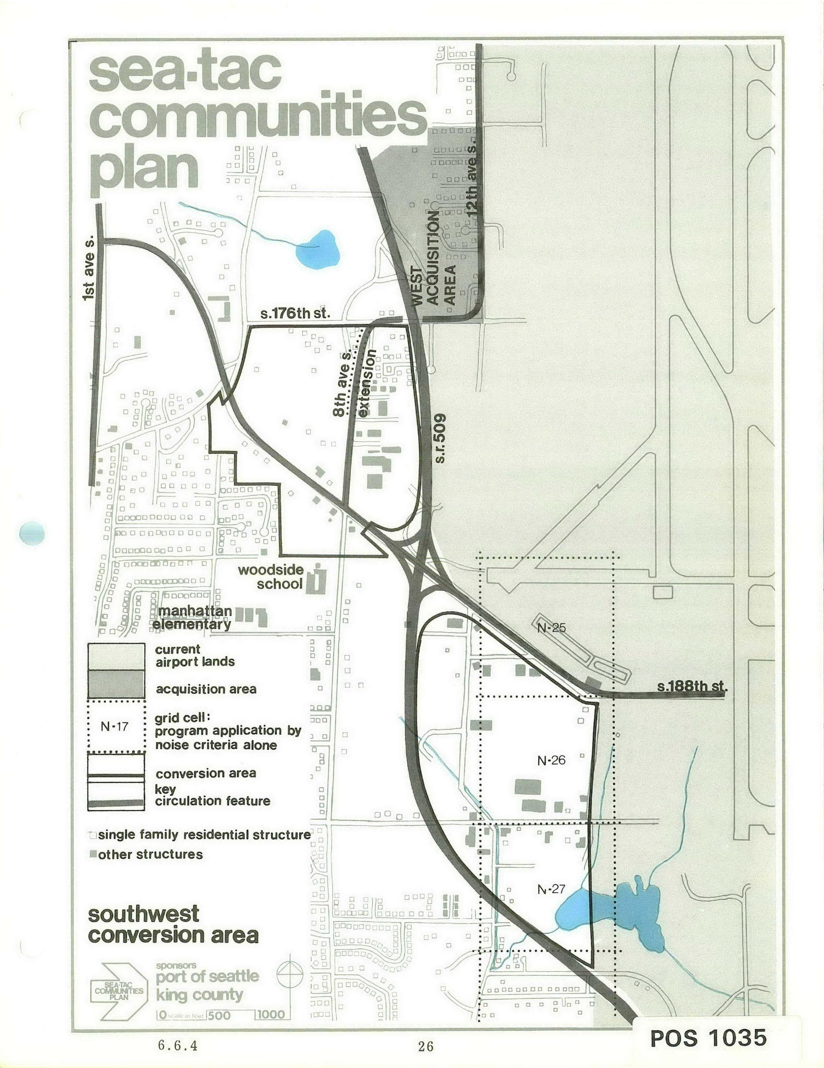
A planning map labeled 'Sea-Tac Communities Plan' depicting the Southwest Conversion Area near Seattle-Tacoma International Airport, showing current airport lands, acquisition areas, grid cells (N-25, N-26, N-27), key streets (S. 176th St., S. 188th St., 1st Ave S., 12th Ave S.), SR 509, the 8th Ave S. extension, and local schools (Woodside School, Manhattan Elementary). Sponsored by the Port of Seattle and King County, document reference POS 1035, page 6.6.4.
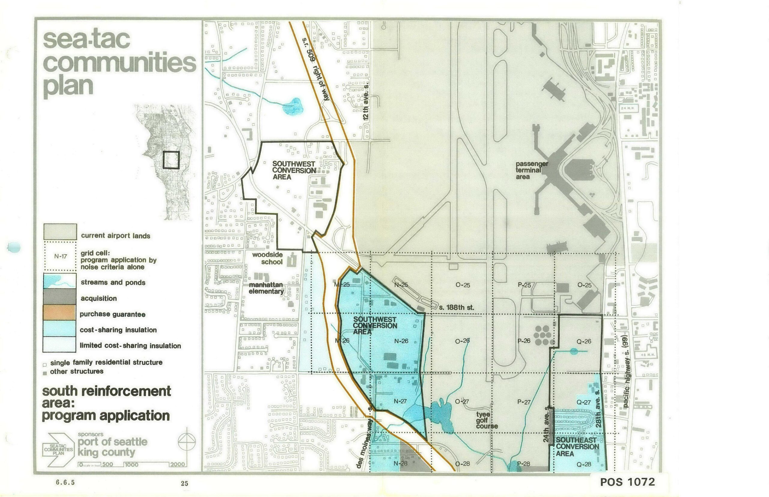
A planning map from the Sea-Tac Communities Plan, document number POS 1072 (dated 6.6.5, page 25), sponsored by the Port of Seattle and King County. The map depicts the South Reinforcement Area program application near Seattle-Tacoma International Airport, showing Southwest and Southeast Conversion Areas, grid cells by noise criteria, acquisition zones, purchase guarantee corridors, cost-sharing insulation areas, and landmarks including Woodside School, Manhattan Elementary, and Tyee Golf Course.
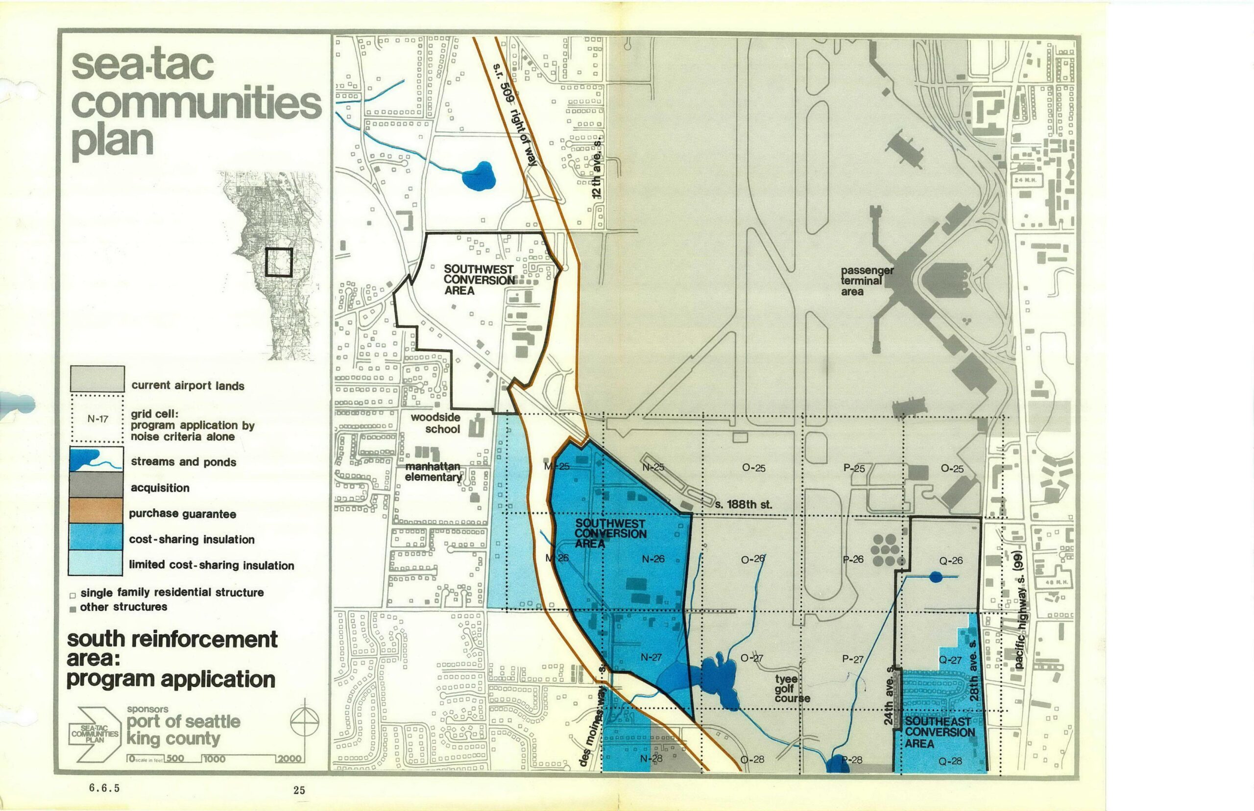
This map from the Sea-Tac Communities Plan, sponsored by the Port of Seattle and King County, depicts the South Reinforcement Area program application showing acquisition zones, purchase guarantee corridors, cost-sharing insulation areas, and conversion zones (Southwest and Southeast) relative to current airport lands and surrounding neighborhoods including Woodside School and Manhattan Elementary. Grid cells, streams, ponds, and residential structures are also identified in the legend.
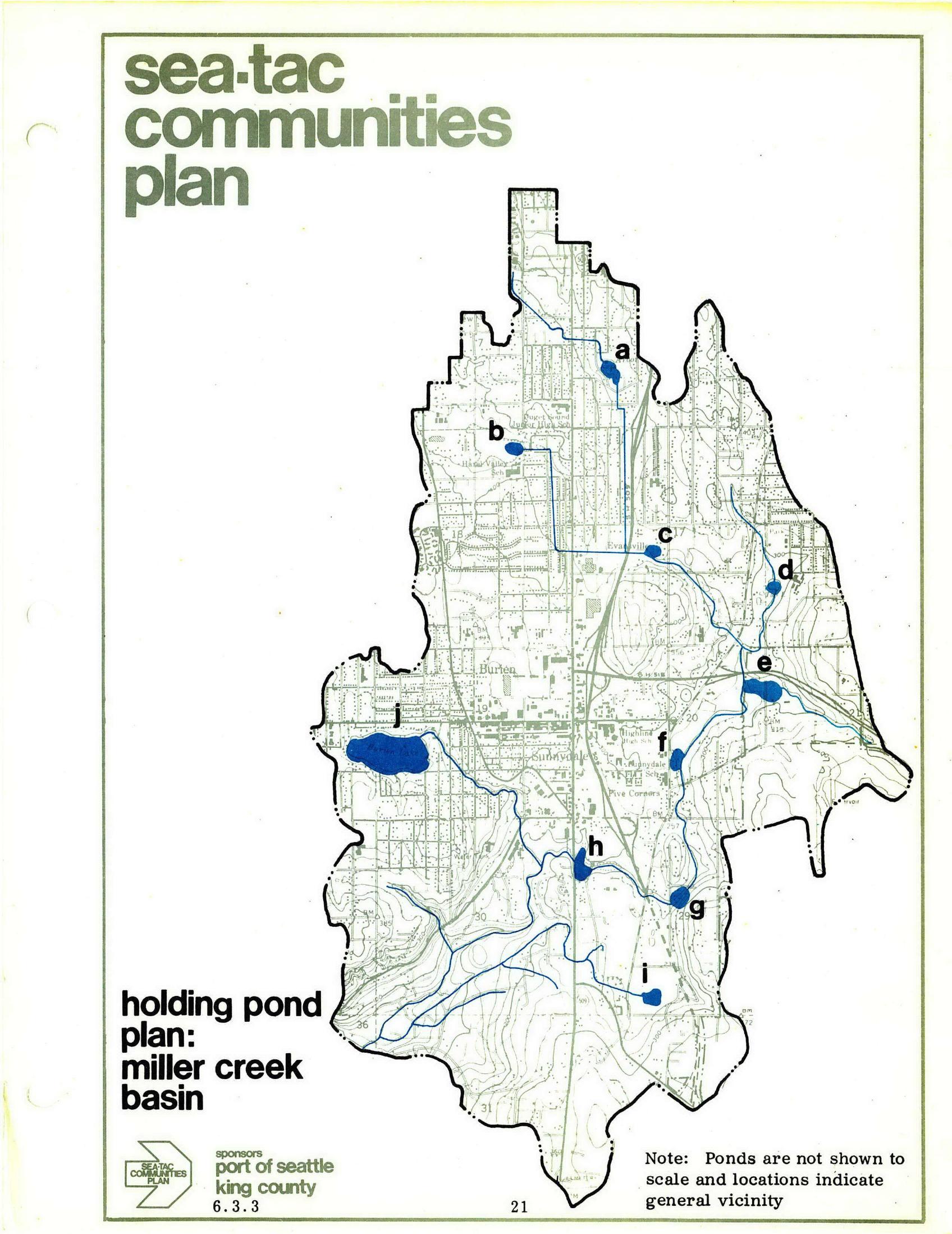
Page 21 of the Sea-Tac Communities Plan, sponsored by the Port of Seattle and King County, showing a holding pond plan map for the Miller Creek Basin. Ten proposed holding pond locations (labeled a through j) are marked in blue within the plan boundary, with a note that pond sizes are not to scale and locations indicate general vicinity only.
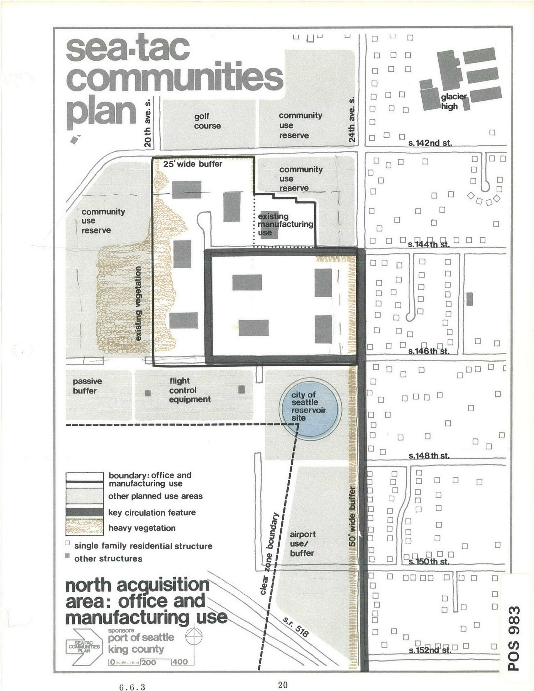
A planning map labeled 'Sea-Tac Communities Plan' showing the north acquisition area designated for office and manufacturing use, sponsored by the Port of Seattle and King County. The map depicts land uses including a golf course, community use reserves, existing vegetation, flight control equipment, a City of Seattle reservoir site, airport use/buffer zones, a 50-foot wide buffer, and a clear zone boundary along S.R. 518, with reference number POS 983 and page number 6.6.3/20.
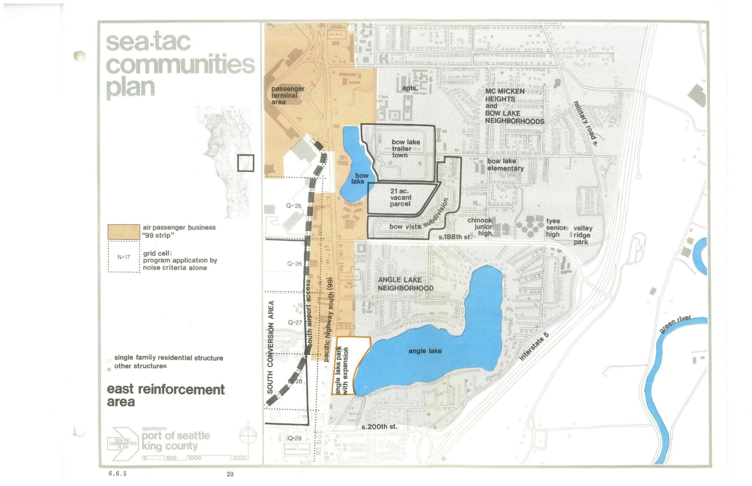
A planning map from the Sea-Tac Communities Plan, sponsored by the Port of Seattle and King County, depicting the East Reinforcement Area including the McMicken Heights, Bow Lake, and Angle Lake neighborhoods. The map identifies key features such as Bow Lake trailer town, a 21-acre vacant parcel, Bow Vista subdivision, Angle Lake park expansion, the South Conversion Area, the Pacific Highway South (99) corridor, and noise-criteria grid cells (Q-25 through Q-29), with a scale bar and north arrow shown.
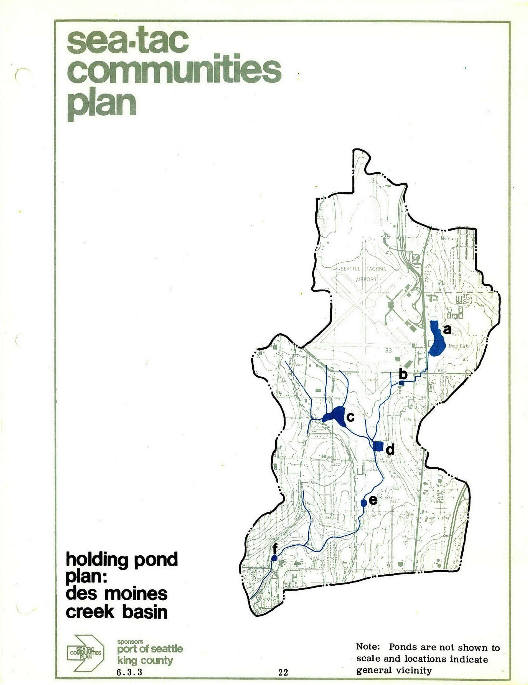
A planning map from the Sea-Tac Communities Plan, sponsored by the Port of Seattle and King County, showing the Des Moines Creek Basin holding pond locations (labeled a through f) in relation to Seattle-Tacoma Airport and surrounding areas, including Hog Lake. A note indicates ponds are not shown to scale and locations indicate general vicinity only.
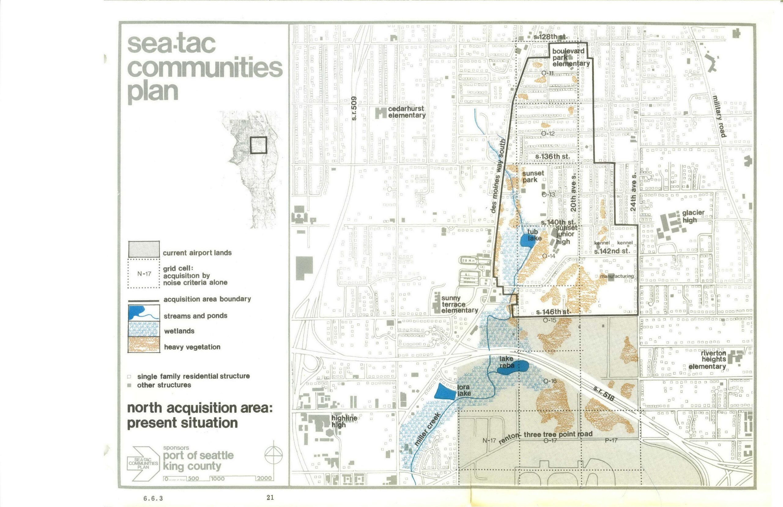
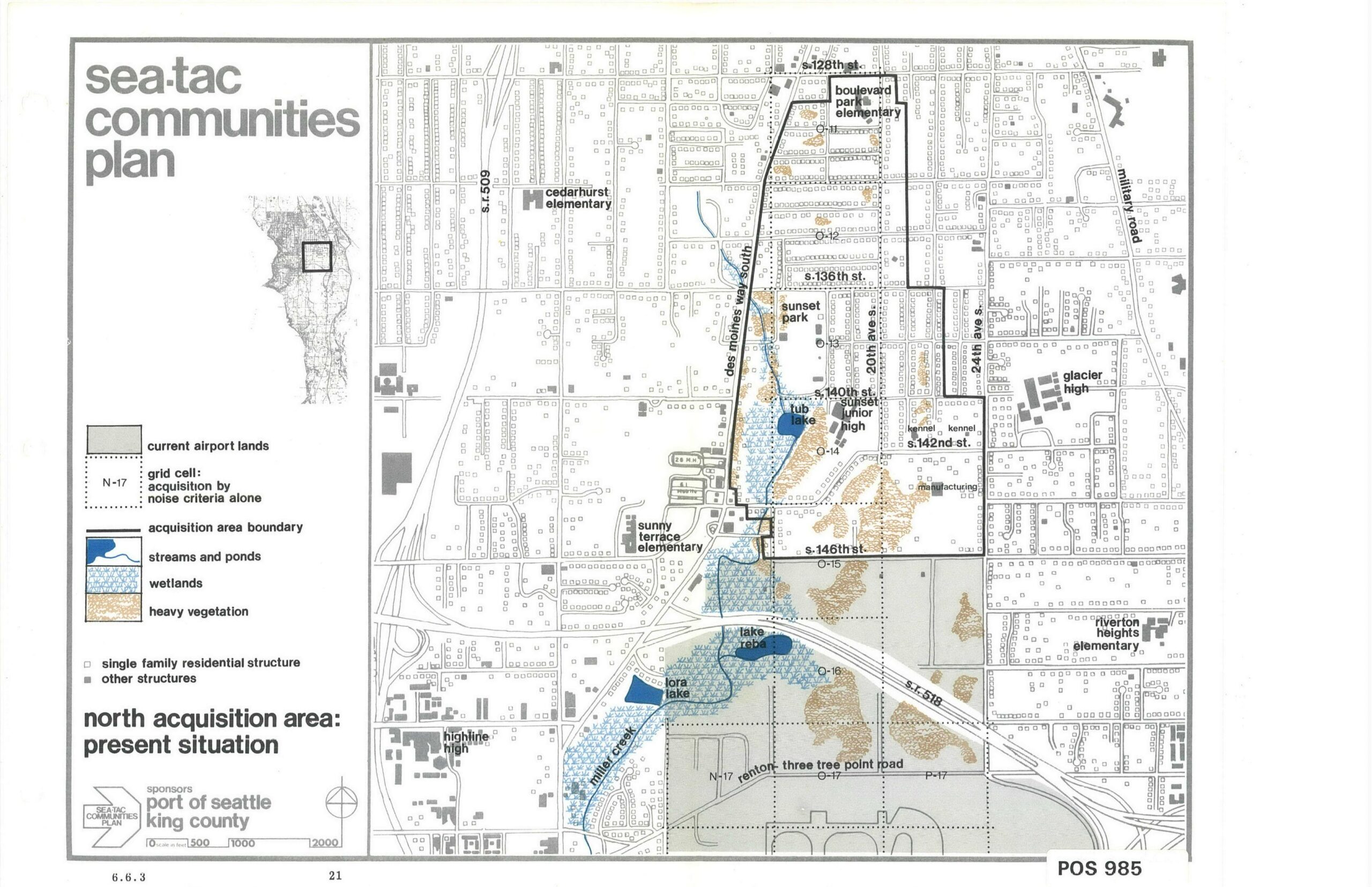
A planning map sponsored by the Port of Seattle and King County as part of the Sea-Tac Communities Plan, depicting the North Acquisition Area and its present situation. The map identifies schools (Boulevard Park Elementary, Cedarhurst Elementary, Sunset Junior High, Glacier High, Highline High, and others), land features (wetlands, streams, heavy vegetation), grid cells subject to acquisition by noise criteria alone, and key streets including S. 128th St., S. 136th St., S. 140th St., S. 146th St., and State Routes 509 and 518.
This map, labeled page 21 and document reference POS 985, is from the Sea-Tac Communities Plan sponsored by the Port of Seattle and King County. It depicts the north acquisition area around Sea-Tac Airport, showing current airport lands, acquisition area boundaries, wetlands, streams, heavy vegetation, and residential structures, with landmarks including Boulevard Park Elementary, Sunset Junior High, Glacier High, Highline High, and streets such as S. 128th St. through S. 146th St.
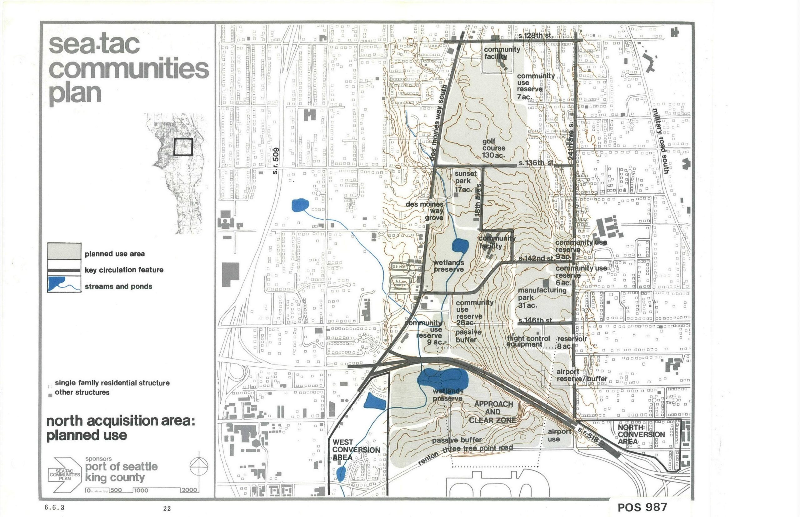
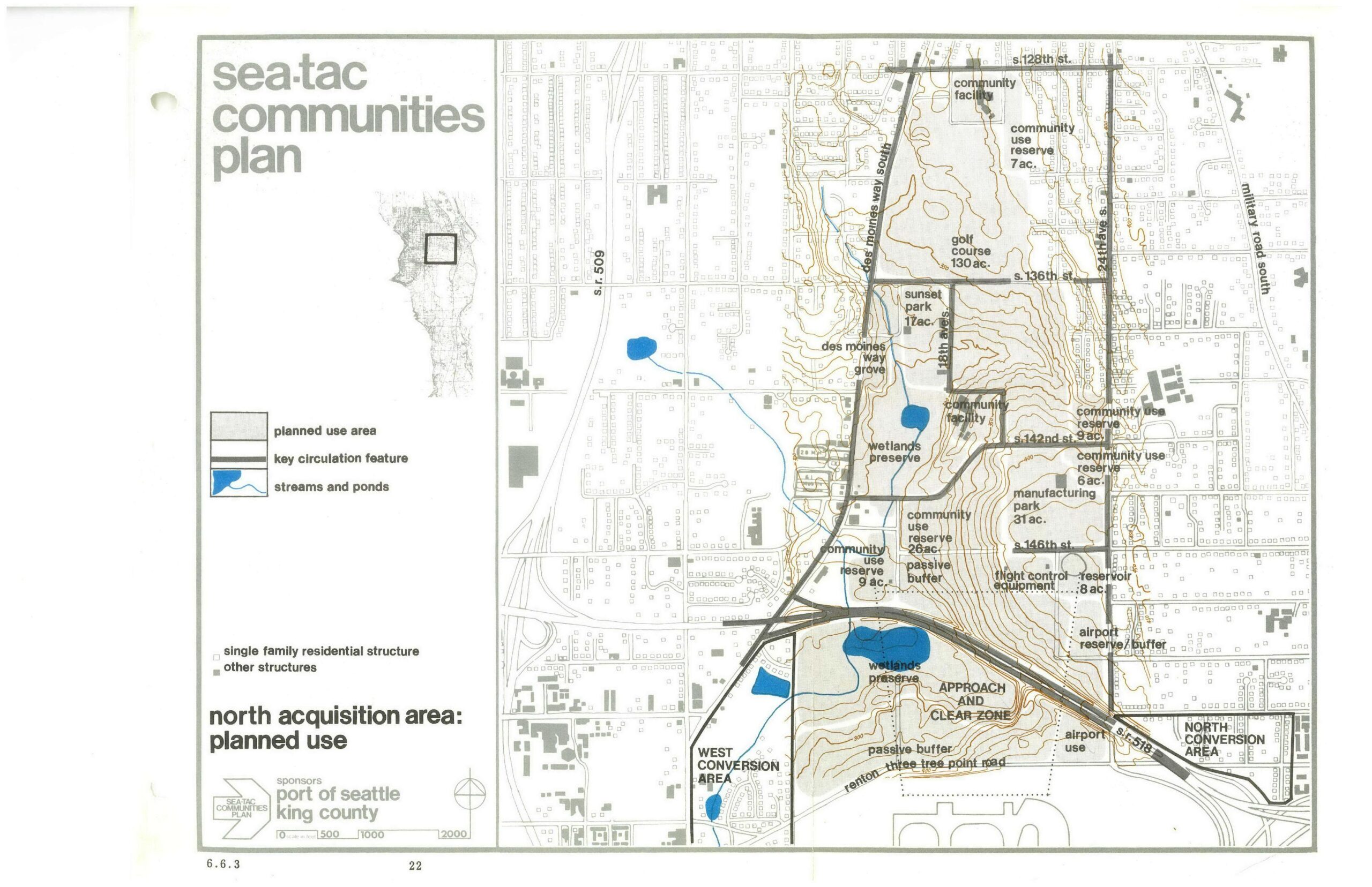
This planning map, labeled 'POS 987' and page 22 (section 6.6.3), is from the Sea-Tac Communities Plan sponsored by the Port of Seattle and King County. It depicts the North Acquisition Area planned land uses, including wetlands preserves, community use reserves, a golf course (130 ac.), manufacturing park, airport reserve/buffer zones, and approach/clear zones around Seattle-Tacoma International Airport.
A land-use planning map from the Sea-Tac Communities Plan, sponsored by the Port of Seattle and King County, showing the North Acquisition Area's planned uses including wetlands preserves, community use reserves, a golf course (130 ac.), Sunset Park (17 ac.), manufacturing park (31 ac.), passive buffers, flight control equipment area, airport reserve/buffer, and approach and clear zone designations. Key streets visible include S. 128th St., S. 136th St., S. 142nd St., S. 146th St., Des Moines Way South, 24th Ave. S., and Military Road South.
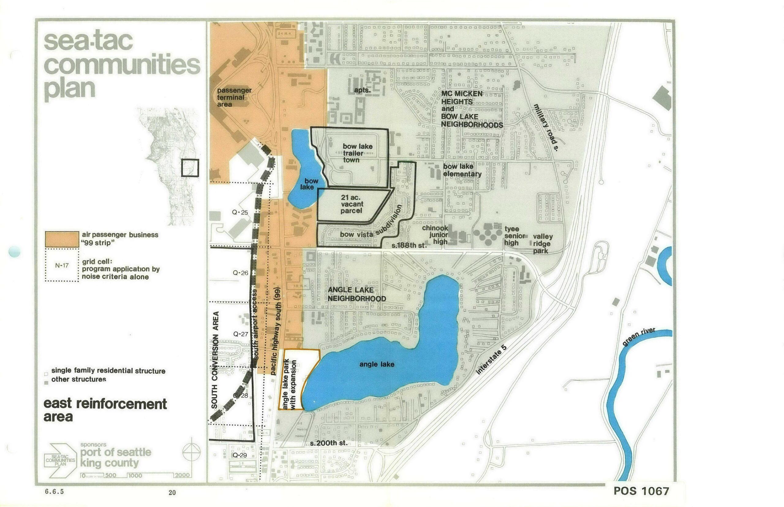
This planning map, document number POS 1067 (page 6.6.5, sheet 20), was produced for the Sea-Tac Communities Plan sponsored by the Port of Seattle and King County. It depicts the East Reinforcement Area, showing the air passenger business '99 Strip,' Bow Lake, Angle Lake neighborhood, the South Conversion Area, grid cells subject to noise-criteria program application, and surrounding features including McMicken Heights, Bow Lake Elementary, Chinook Junior High, and Interstate 5.
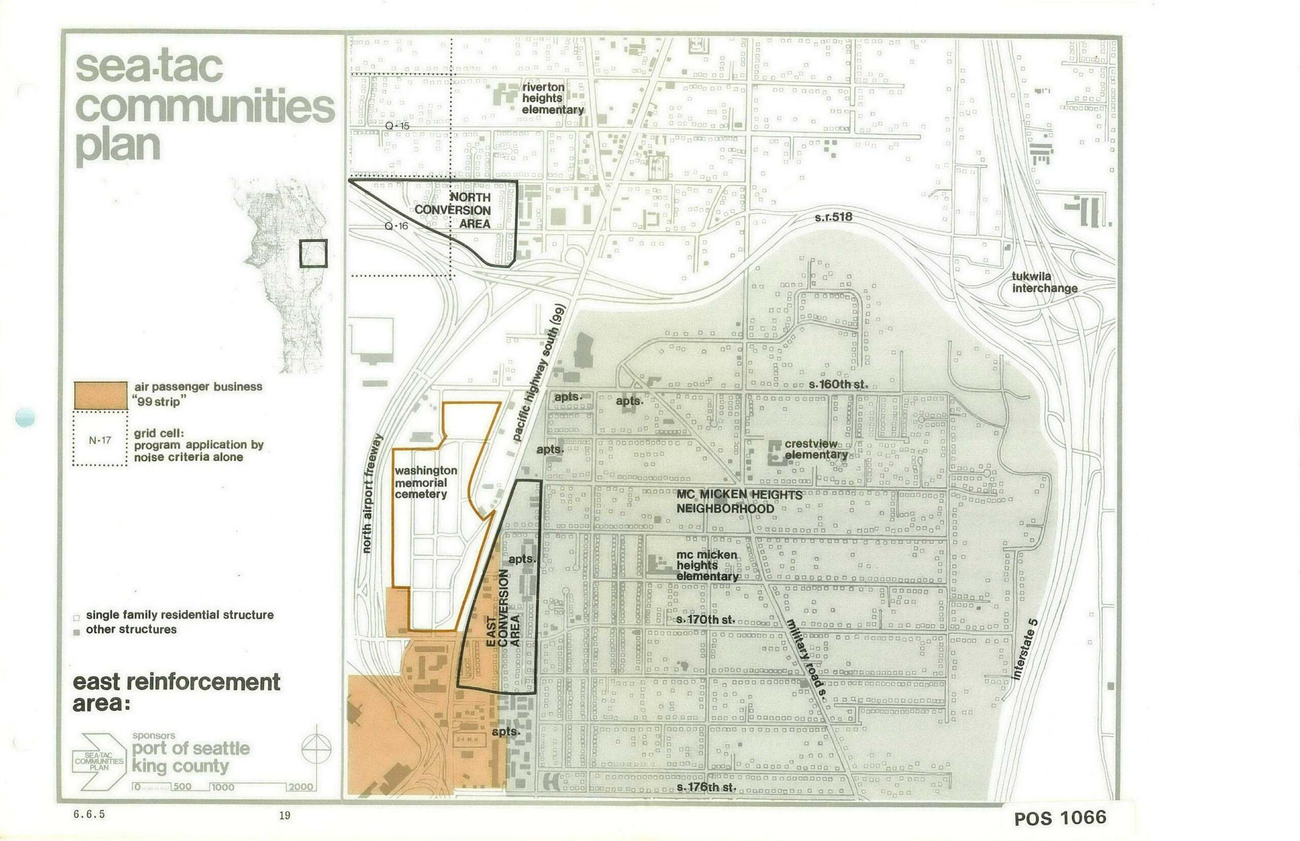
Planning map (document number POS 1066, page 19, section 6.6.5) from the Sea-Tac Communities Plan, sponsored by the Port of Seattle and King County, depicting the East Reinforcement Area near Sea-Tac Airport. The map identifies the North and East Conversion Areas, the McMicken Heights Neighborhood, Washington Memorial Cemetery, Pacific Highway South (SR 99), the North Airport Freeway, and surrounding elementary schools, with a legend distinguishing air passenger business '99 strip' zones and grid cells subject to noise criteria.
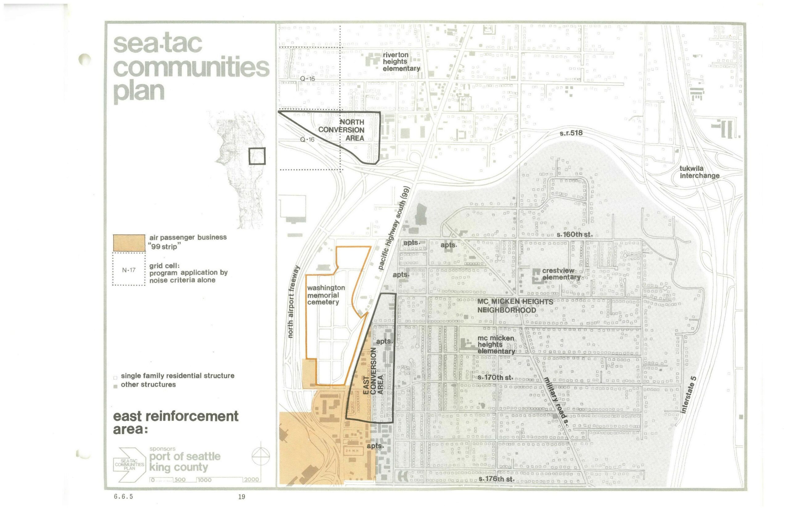
A planning map from the Sea-Tac Communities Plan, sponsored by the Port of Seattle and King County, depicting the East Reinforcement Area near Seattle-Tacoma International Airport. The map identifies the North and East Conversion Areas, the Washington Memorial Cemetery, McMicken Heights Neighborhood, Pacific Highway South (SR-99), the North Airport Freeway, Interstate 5, SR-518, and the Tukwila Interchange, with land-use designations including air passenger business '99 strip' and grid cells subject to noise criteria.
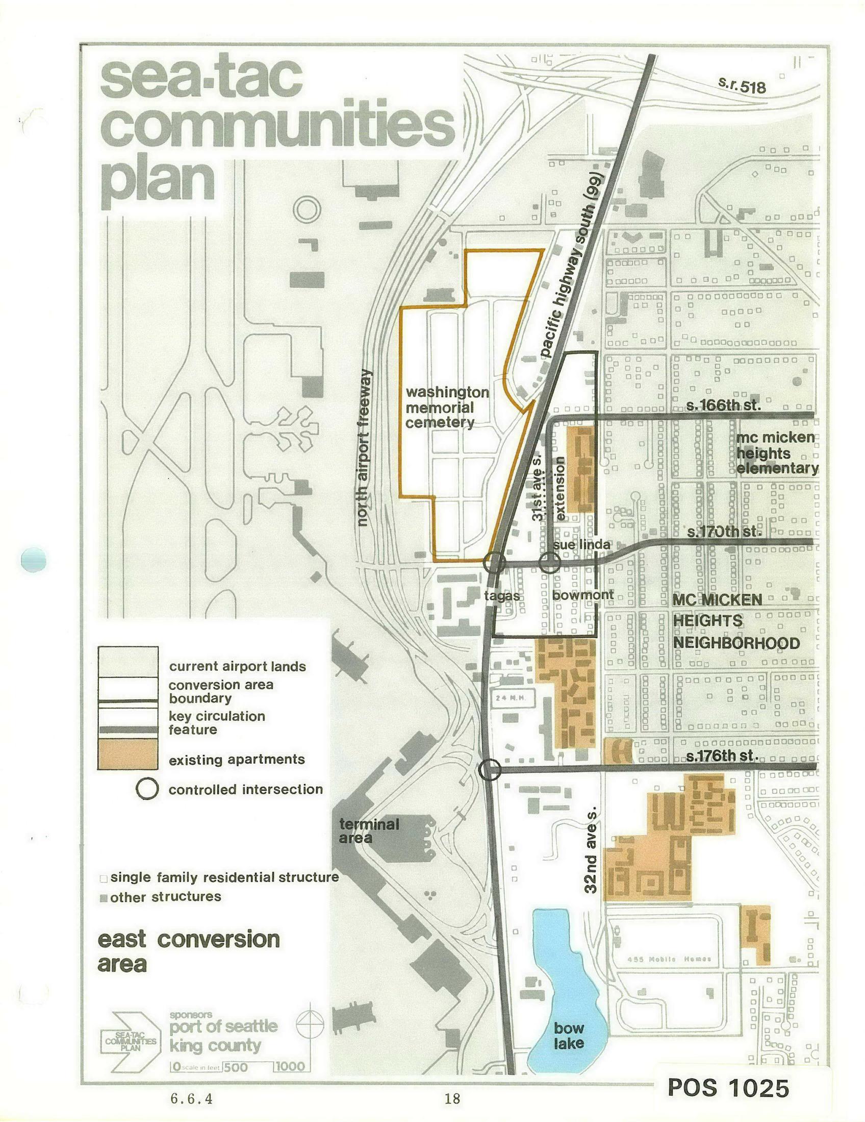
Planning map labeled 'Sea-Tac Communities Plan – East Conversion Area,' document number POS 1025 (page 18, section 6.6.4), sponsored by the Port of Seattle and King County. The map depicts the area east of Sea-Tac Airport bounded by S.R. 518 to the north and Bow Lake to the south, showing current airport lands, conversion area boundaries, existing apartments, controlled intersections, and key streets including Pacific Highway South (99), S. 166th St., S. 170th St., and S. 176th St., with labeled features including Washington Memorial Cemetery and the Mc Micken Heights Neighborhood.
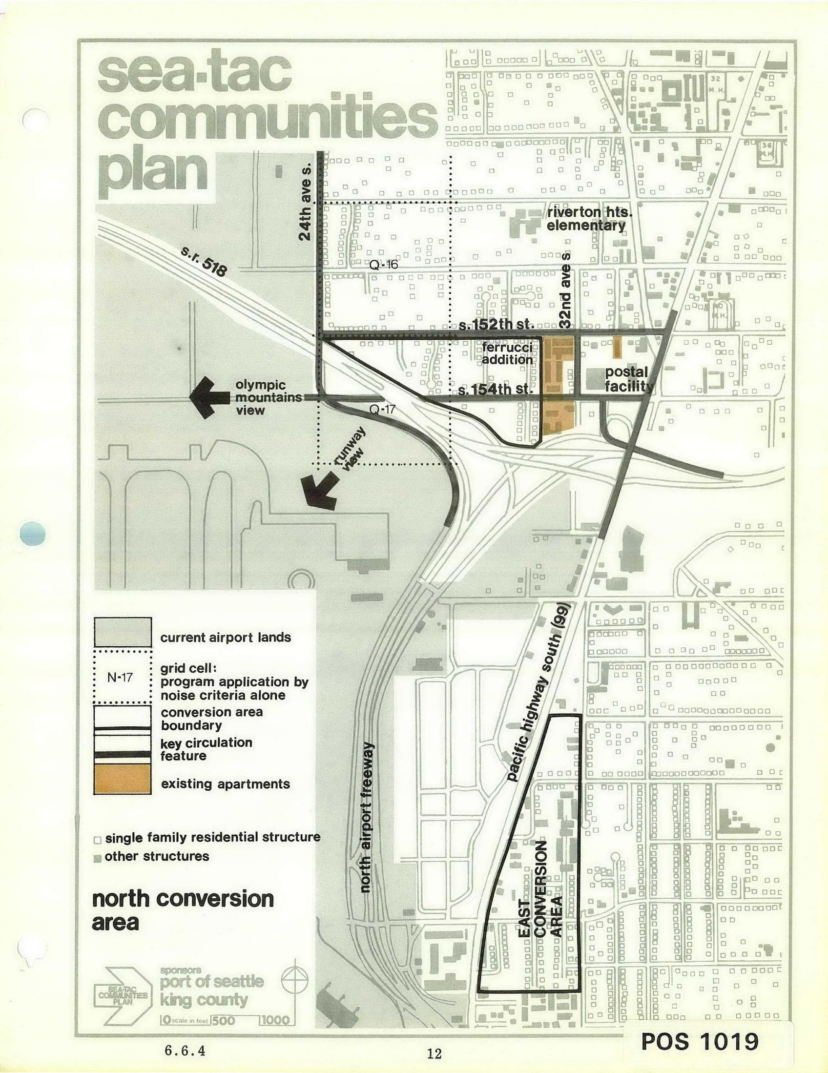
A planning map labeled 'Sea-Tac Communities Plan' showing the North Conversion Area near Seattle-Tacoma Airport, identifying key features including S.R. 518, S. 152nd and S. 154th Streets, 24th and 32nd Avenues S., Riverton Heights Elementary, a postal facility, Ferrucci Addition, grid cells Q-16 and Q-17, Olympic Mountains view corridor, runway view corridor, and the East Conversion Area along Pacific Highway South (99). Sponsored by the Port of Seattle and King County, document reference POS 1019, page 6.6.4.
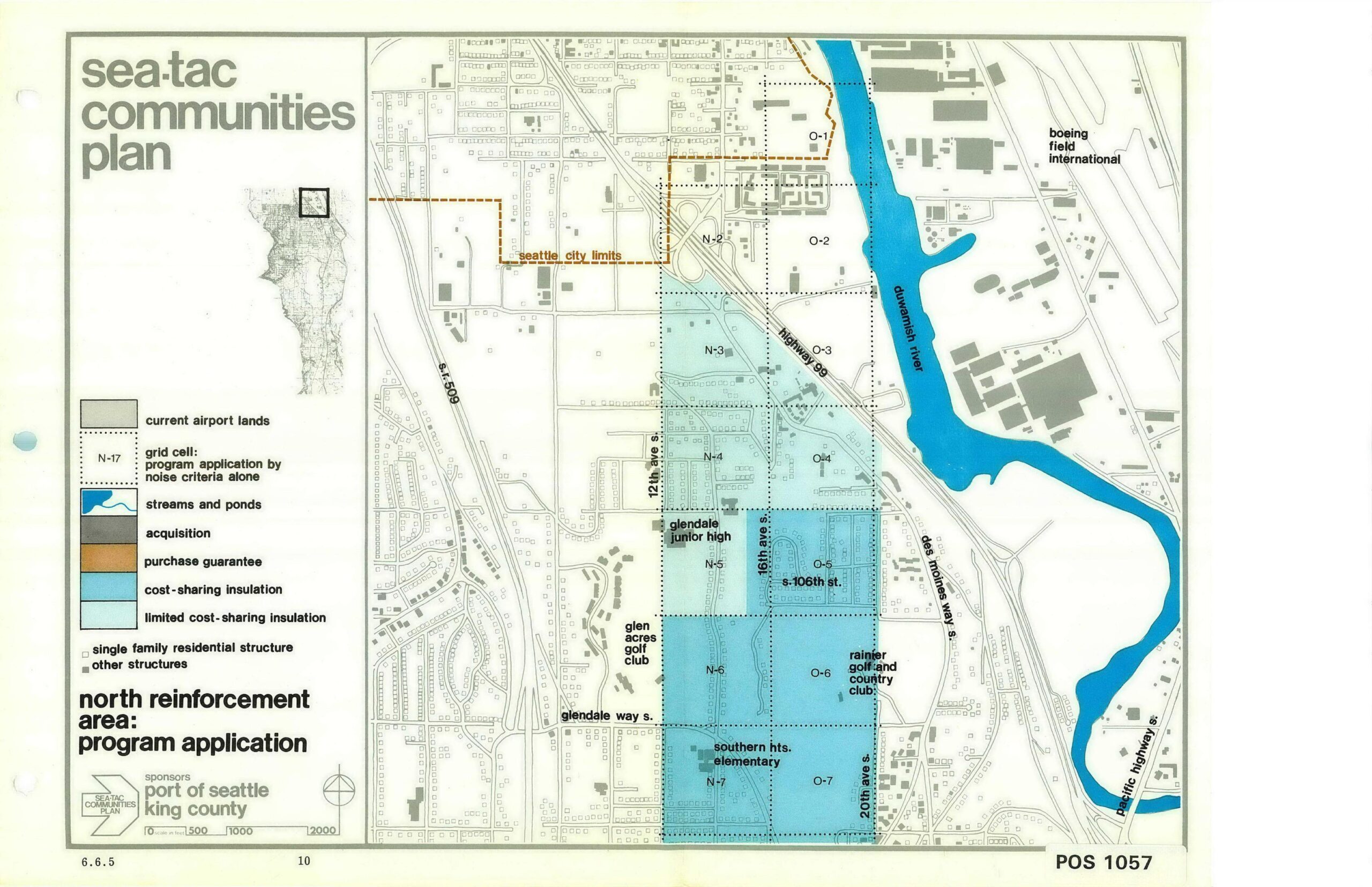
This planning map (document number POS 1057, sheet 6.6.5, page 10) from the Sea-Tac Communities Plan depicts the North Reinforcement Area program application, showing grid cells N-1 through N-7 and O-1 through O-7 near Seattle-Tacoma International Airport. Sponsored by the Port of Seattle and King County, the map identifies land-use categories including current airport lands, acquisition zones, purchase guarantee areas, cost-sharing insulation areas, and limited cost-sharing insulation areas, with landmarks such as Boeing Field International, the Duwamish River, Glendale Junior High, Southern Heights Elementary, and Rainier Golf and Country Club.
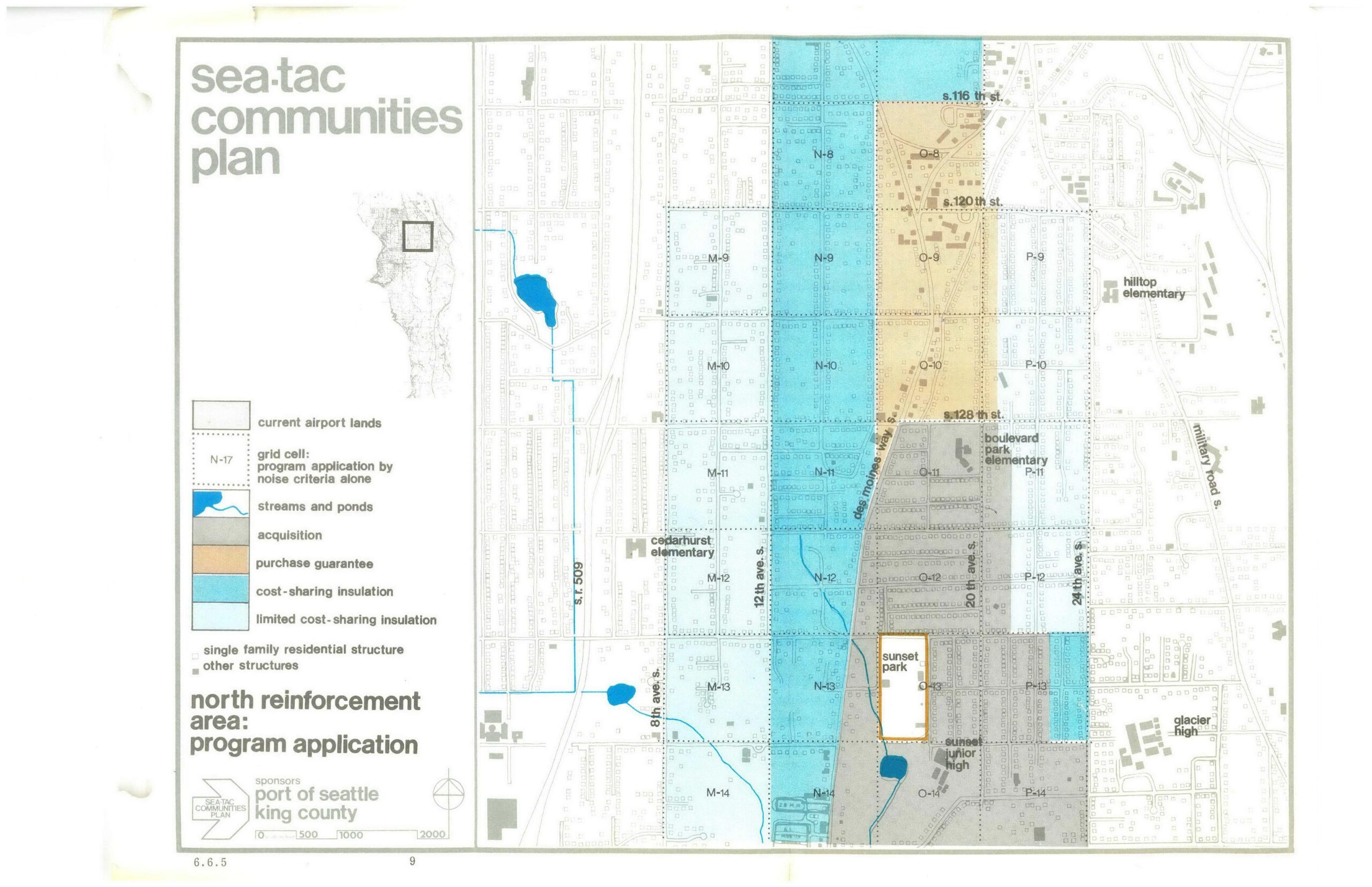
This map from the Sea-Tac Communities Plan, sponsored by the Port of Seattle and King County, depicts the North Reinforcement Area program application showing grid cells color-coded by noise mitigation category—including acquisition, purchase guarantee, cost-sharing insulation, and limited cost-sharing insulation zones. Landmarks visible include Cedarhurst Elementary, Boulevard Park Elementary, Hilltop Elementary, Sunset Park, Sunset Junior High, and Glacier High, with major streets including S. 116th St., S. 120th St., S. 128th St., and Des Moines Way S.
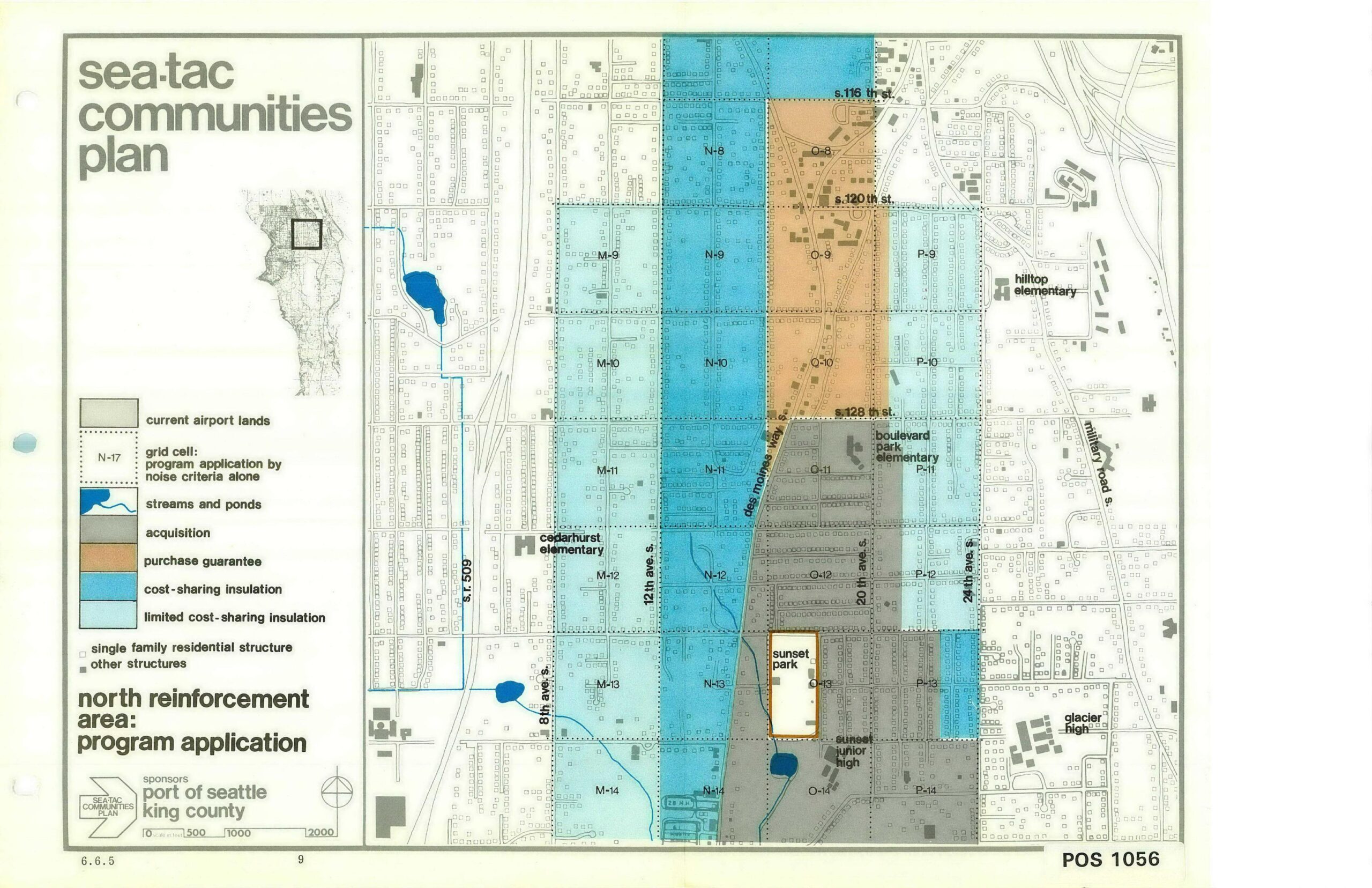
This planning map, document number POS 1056 (page 9, section 6.6.5), was produced under the Sea-Tac Communities Plan sponsored by the Port of Seattle and King County. It depicts the North Reinforcement Area program application, showing grid cells classified by noise-mitigation programs—including acquisition, purchase guarantee, cost-sharing insulation, and limited cost-sharing insulation—across neighborhoods near Seattle-Tacoma International Airport, with landmarks such as Cedarhurst Elementary, Boulevard Park Elementary, Hilltop Elementary, Glacier High, and Sunset Junior High identified.
The Sea-Tac Communities Plan really was a plan. Because Sea-Tac Airport was sited in a growing area, the Second Runway expansion presented huge challenges. Sea-Tac became the ‘alpha-tester’ for many FAA initiatives.
The question they were trying to answer was: how can any major airport function in harmony with its surroundings? One idea, which the STCP helped pioneer was the concept of Noise Density Guidelines — what are the appropriate land uses for any area based on noise?
The following is a gallery of which break down land use into three categories:
Acquisition
Conversion
Reinforcement
Every aspect of the STCP evolved over its three years in development, so there are multiple versions of several maps–each with slight differences. We’ve retained these to demonstrate its flexibility. There may be more than one appropriate use for each area.
We use cookies to provide basic functionality. We also provide access to search engines in order to provide site analytics. We do not sell or share your data.