Skip to content
  • STNI
  • Statistics
    • Ops and Passengers
      • King County International Airport (Boeing Field) Annual Operations
    • Financials
    • Aviation fuel uplift in the State of Washington 2018 – 2025
      • Aviation Fuel Tax Revenue in the State of Washington 1983-2025
      • Aviation Fuel Uplift at Sea-Tac Airport
    • Air Quality Monitoring
    • Flight Tracking
      • Flow and Flight Tracks
      • Five Year Comparison
      • Busiest Hours and Days
    • SEL Noise Reports & Graphs
      • About The Permanent Noise Monitors
      • Minutes of Quiet by Noise Monitor
      • Noise Events mapped
      • Noise Events (SEL)
    • Runways
    • Employees
    • Real Estate
      • Port Properties and Trees mapped
    • Parking
  • Events
  • Protest
    • Regular Events
    • Legislation 2026
    • Complain about a particular flight
    • Advocacy Organizations
    • Media Outlets
    • People
    • The Port of Seattle
      • Commission Meetings
      • Public Records Requests
      • StART
      • Highline Forum
    • Contact Your Electeds
  • Resources
    • FAQs
      • FAA Occurrences/Accidents/Indents
    • The SAMP
      • SAMP Public Comment Template
        • Two versions of Appendix K: NEPA/SEPA 2018 vs 2023
      • SAMP NTP: 31 projects by the numbers
      • SEPA Draft EIS (2026)
      • SAMP Record of Decision/FONSI (2025)
      • SAMP Draft EA (October 2024)
      • 2018 Scoping
    • Port Packages
      • Port Package Property Costs
      • Port Packages mapped
      • The Port Package Explainer
      • So you want a (first-time) Port Package? Start here
      • Port Package Looker Upper
      • How do I determine if I have a Port Package or Avigation Easement?
      • Progress on Port Package Update legislation
      • Having a Port Package Problem?
      • Port Package Site Visit Follow-Up
    • Document Library
    • Explainers
      • The Airport Law Cheat Sheet
      • The Grant Explainer
    • External Articles
    • History
      • Timeline
      • The Sea-Tac Communities Plan
        • Sea-Tac Communities Plan – Planning Maps
      • PSRC Third Runway Decision Process
    • Studies
    • Videos
  • Stories
  • Mission
  • Subscribe
  • Contact
Scroll down to content

Get InformedStay Informedx

I understand that you will never share my information with anyone, you will only use it to keep me updated on relevant events and that I may unsubscribe at any time.

STNI

STNISea-Tac Noise.Info

  • Solve for Sea-Tac. Solve for every airport.
  • Since 2016, working to obtain justice for everyone living under the flight path.
  • Less Noise. Cleaner Air. Better Public Health. Compensation.
  • Everything you think you know about the airport is wrong.

TagLand Use(212)

Advanced Search Options

  • Dates
  • Media
    • External Articles
    • Images
    • PDFs
    • Video
    • Audio
  • Order By
  • 2010-04-01

    Northeast Redevelopment Area (NERA) appendix

    The Northeast Redevelopment Area (NERA) Appendix is a supporting document to the Redevelopment Plan and Implementation Strategy, dated April 2010. It contains nine sections covering existing conditions, market conditions, critical area studies, community involvement, transportation infrastructure, economic summaries, comprehensive plan and zoning amendments, and a Miller Creek Greenway concept report. This appendix provides the technical and community engagement background needed to guide redevelopment planning decisions for the NERA.
    Tagscommunity development, Land Use, Miller Creek, NERA, Northeast Redevelopment AreaFolderBurien
  • 2009-12-21

    Port of Seattle to pay BNSF 81m for Eastside rail line

    The Port of Seattle announced today it is buying the partially abandoned Renton-to-Seattle rail line from BNSF Railway for a reduced price of $81.4 million — a deal that may eventually lead to side-by-side trails and passenger trains. By Keith Ervin A weakened real-estate market and the Port of Seattle’s financial strains led the agency
    CategoriesFrom The Web TagsKing County, Land Use, Port Of Seattle, Seattle Times
  • Port of seattle bnsf king county 2003988989
    2007-11-02

    Port to buy Eastside rail corridor | The Seattle Times

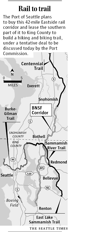
    Port to buy Eastside rail corridor Nov 2, 2007 By Keith Ervin and Bob Young Seattle Times staff reporters In a tentative deal hailed as one of the most important land acquisitions in the region’s history, the Port of Seattle plans to buy a 42-mile Eastside rail corridor and lease the southern portion of it
    CategoriesFrom The Web TagsKing County, Land Use, Port Of Seattle, Seattle Times
  • 2006-02-16

    SeaTac 2005 Interlocal Agreement (ILA-2)

    The 2005 Interlocal Agreement (ILA-2), signed February 16, 2006, is a formal cooperative agreement between the City of SeaTac and the Port of Seattle governing a range of shared responsibilities related to Seattle-Tacoma International Airport. It covers topics including land use and zoning, surface water management, transportation, public safety, and noise policy, while also establishing financial commitments and dispute resolution procedures. The agreement builds on prior 2001 and 2004 interlocal agreements and sets out a framework for ongoing interagency cooperation on airport development and its impacts on the surrounding community.
    TagsCity Of SeaTac, ILA, Interlocal Agreement, Land Use, Port Of SeattleFolderSeaTac
  • 2004-03-09

    Miller and Walker Basins: Parcels likely to redevelop

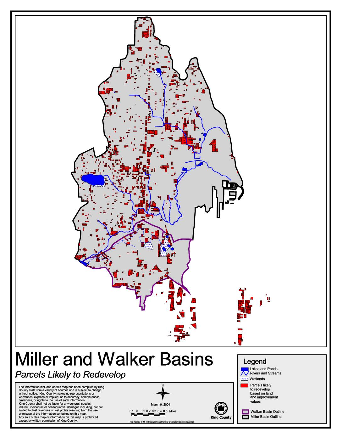
    This King County map, dated March 9, 2004, identifies parcels within the Miller and Walker Basins that are likely to redevelop based on land and improvement values. It highlights features such as lakes, ponds, rivers, streams, and wetlands alongside redevelopment-candidate parcels marked in red. The map was produced by King County staff using data from multiple sources and is intended to support land use planning in these two drainage basins.
    TagsDes Moines Creek, Environment, King County, Land Use, Map, RCAAFolderRCAA
  • 2002-10-22

    Exhibit 701: Streams — Development Standards (Sea-Tac Municipal Code 15.30.340 and King County Code 21A.24.360)

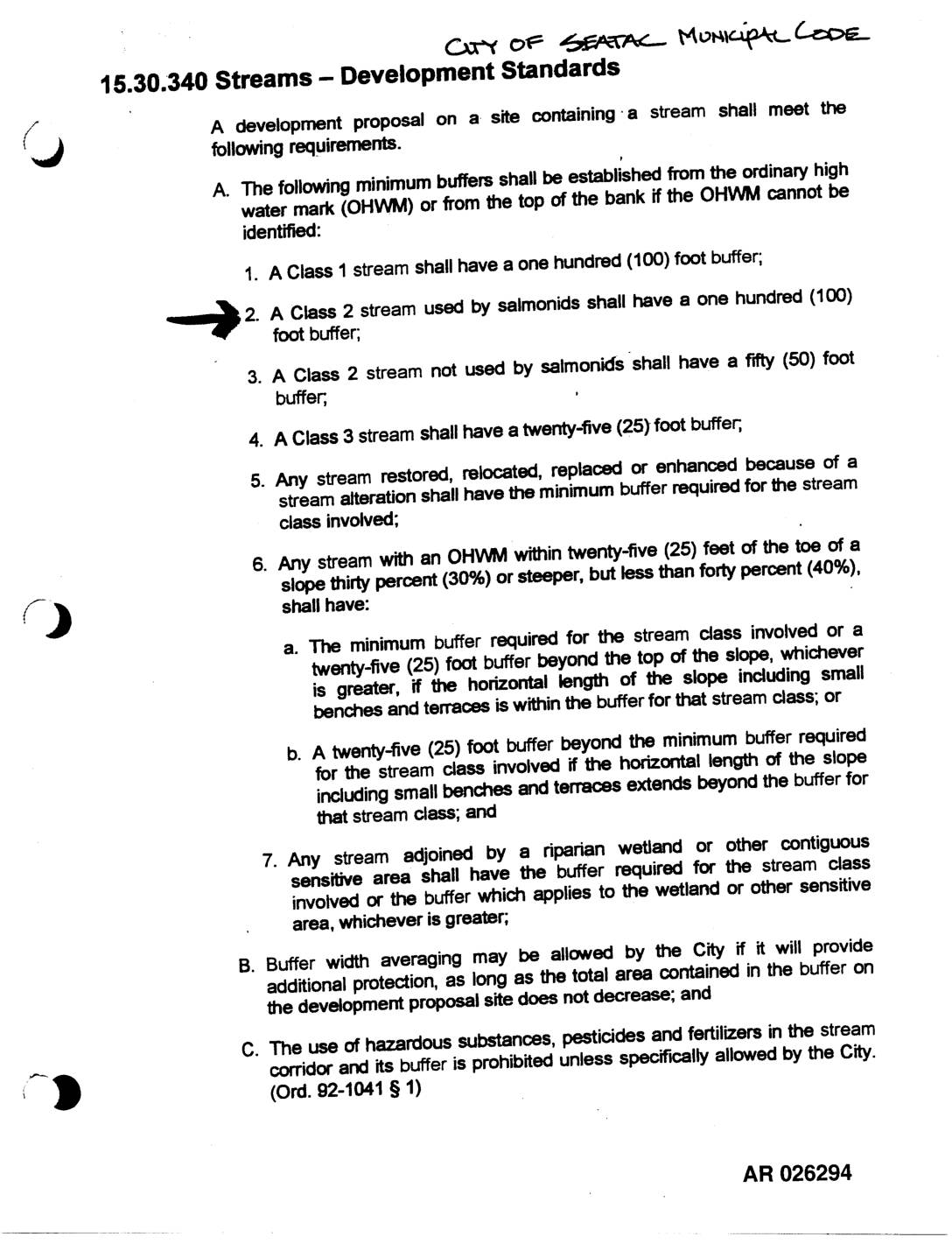
    City of SeaTac Municipal Code section 15.30.340 and King County Code section 21A.24.360 establishing stream development standards and minimum buffer requirements from the ordinary high water mark (OHWM). Specifies buffers for Class 1 streams (100 feet), Class 2 streams used by salmonids (100 feet), Class 2 streams not used by salmonids (50 feet), and Class
    TagsACC, City Of SeaTac, King County, Land Use, Pollution Control Hearings Board, Salmon, Water QualityFolderBox 10
  • 2001-12-14

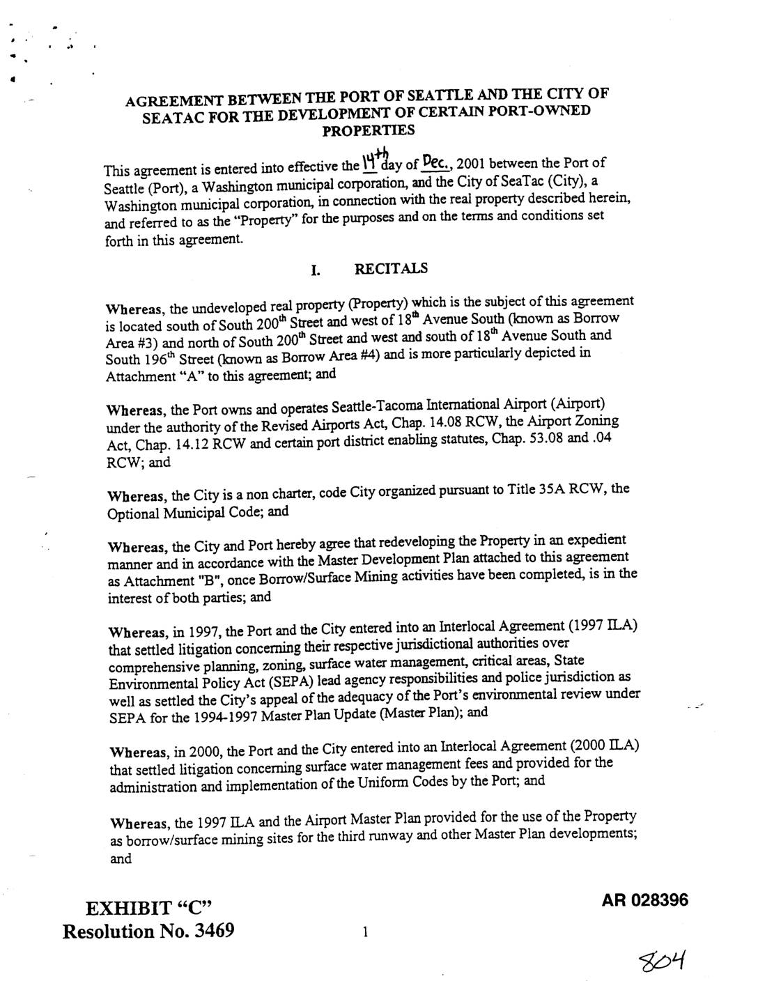
    EXH AR028396: Agreement Between Port Of Seattle and City Of Sea-Tac for Development of Certain Port-Owned Properties

    Agreement effective December 14, 2001 between Port Of Seattle and City of SeaTac for development of Port-owned properties known as Borrow Area #3 (south of South 200th Street, west of 18th Avenue South) and Borrow Area #4 (north of South 200th Street, west and south of 18th Avenue South and South 196th Street). Resolves outstanding
    TagsACC, City Of SeaTac, Interlocal Agreement, Land Use, Pollution Control Hearings Board, Port Of Seattle, Third RunwayFolderBox 10
  • 2001-06-22

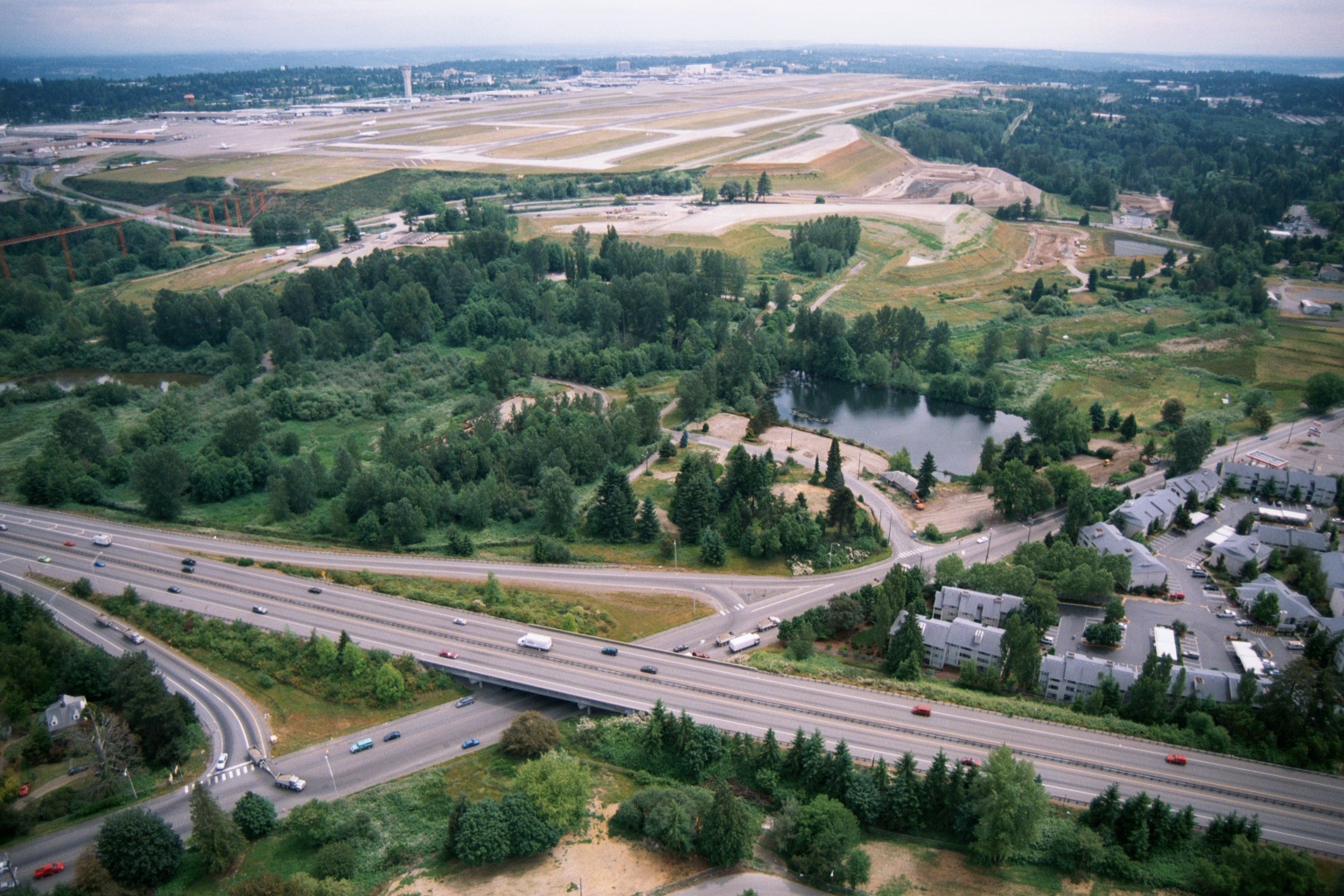
    Aerial View of Sea-Tac Airport Runways with Adjacent Residential Development and Highway Interchange

    Aerial photograph showing Sea-Tac Airport runways and taxiways in the background, with a forested noise buffer area, a retention pond, and a multi-lane highway interchange in the foreground. Residential apartment buildings are visible to the right, illustrating the proximity of the airport to surrounding communities relevant to noise-policy planning.
    TagsAirport Expansion, Land Use, Noise Mitigation, Runways, Sea-Tac AirportFolderWatershed Aerial Photos
  • 2001-06-22

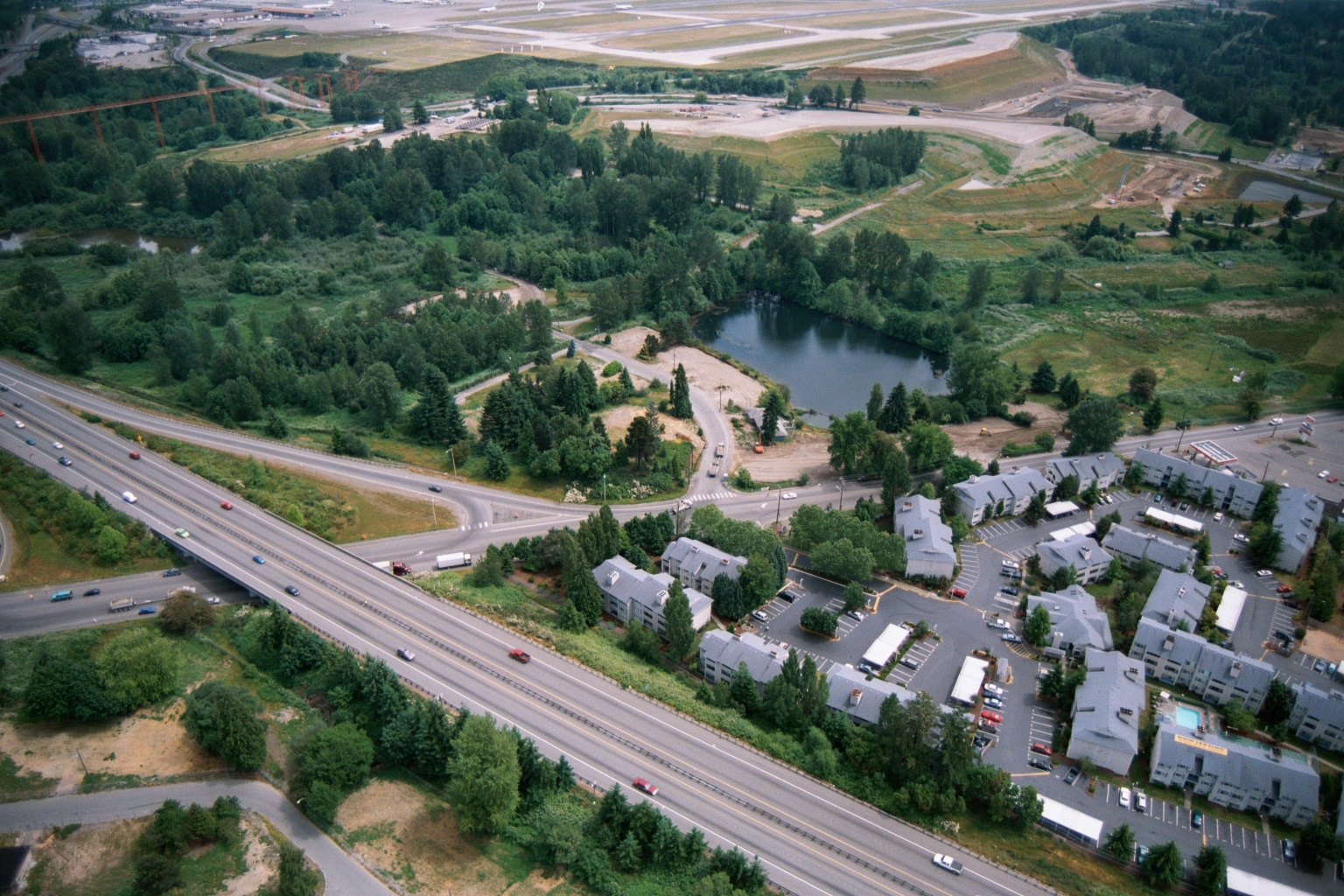
    Aerial View of Highway Interchange, Residential Complex, and Sea-Tac Airport Runway Infrastructure

    Aerial photograph showing a multi-lane highway interchange (likely I-5 or SR-99 corridor near Sea-Tac Airport) with a residential apartment complex, a small retention pond, dense tree buffers, and what appears to be airport runway infrastructure visible in the upper background. No visible text, watermarks, or captions are present in the image.
    Tagsaircraft, Land Use, Noise Mitigation, Runways, Sea-Tac AirportFolderWatershed Aerial Photos
  • 2001-06-22

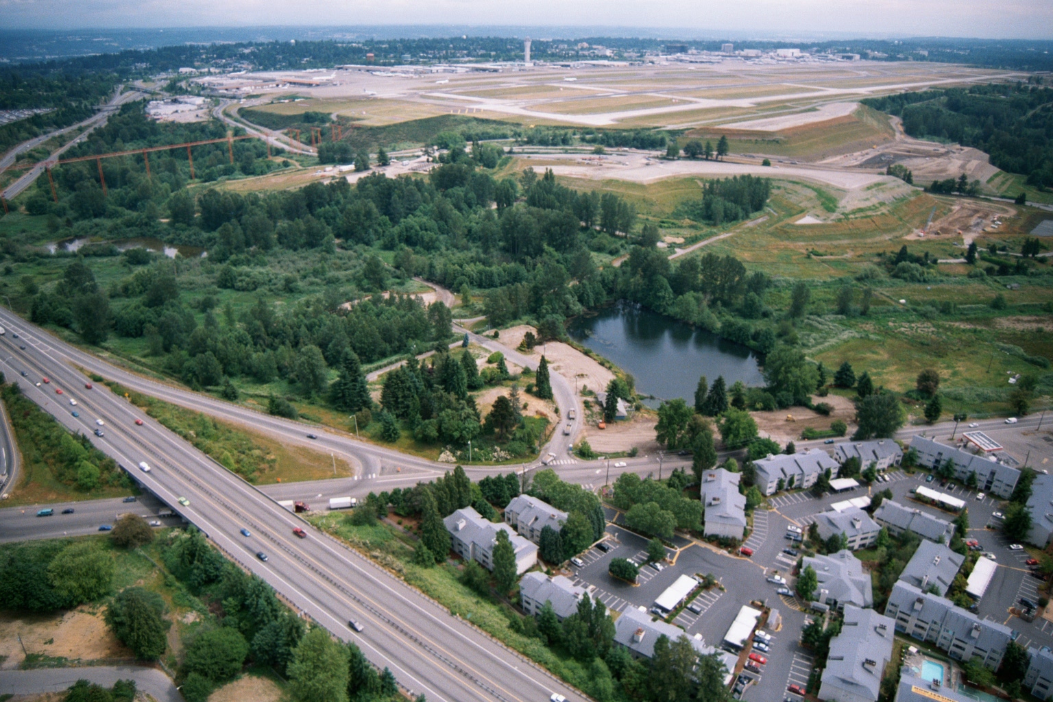
    Aerial View of Sea-Tac Airport Expansion, Highway, and Adjacent Residential Development

    Aerial photograph showing a large airport with runways under construction or expansion in the background, a multi-lane highway running diagonally through the frame, a small pond surrounded by green space, and a residential apartment complex in the foreground. The proximity of the residential development, green buffer zone, and airport infrastructure suggests this image relates to land use and noise-impact planning near a major airport, consistent with Sea-Tac Airport environs.
    TagsAirport Expansion, Housing, Land Use, Sea-Tac AirportFolderWatershed Aerial Photos

Posts pagination

Page 1 … Page 12 Page 13 Page 14 Page 15 Page 16 … Page 22
Sidebar On/Off

Upcoming Events

  • Burien Airport Committee Meeting September 15, 2026
    Add to CalendarMTuesday Sep 15: 6:00pm
    400 SW 152nd St, Burien, WA 98166
    Burien airport committee 15 sep 2026 agenda pdf pdf

    a) Part 150 Noise Study (Emily Inlow-Hood) — 15 minutes
    b) SAMP Update and Next Steps (Brian Davis and Sarah Moore) — 15 minutes
    c) Legislative Updates — 10 minutes
       • SCA (Sarah Moore)
       • Work with Sen. Orwall (Brian Davis)
    d) StART Reorganization (Jeff Harbaugh and Karen Veloria) — 10 minutes

    [...]

[See all...]


Help study childhood asthma. Get free HEPA filter!

read more...

Issues

Sea-Tac Airport is currently undergoing the largest and longest expansion in its history, collectively known as the Sustainable Airport Master Plan (SAMP). Some of it you can already hear, but you’re probably not aware of what it all means. Here’s what you need to know.
read more...

Read This!

As the source for federal transportation grants, the Puget Sound Regional Council was charged with developing a system to meet the growing need for commercial aviation. When the search for a second airport failed, they authorized the Port of Seattle to build the Third Runway, with a mandate to develop a noise abatement and mitigation program. In their effort to stop the Third Runway, the ACC argued over every detail of the Port's efforts--including property buyouts and sound insulation. The dispute was meant to be settled by a three member Expert Arbitration Panel. This is their final report. It finds 2-1, that the Port's program was insufficient in several respects. Despite that, funding for the Third Runway was approved by the PSRC, and the 'Port Package' program, proceeded largely unchanged. Expert Arbitration Panel's final decision finding that the Port of Seattle had not shown sufficient reduction in real on-the-ground noise impacts to satisfy noise reduction conditions required for approval of a third runway at Sea-Tac International Airport. The majority decision concluded the Port's noise abatement programs were insufficient despite being impressive in scope.
continue...

The Podcast!

Subscribe to the only podcast devoted to policies, politics, history, impacts for people living under the flight path everywhere. It’s definitely not just about noise!
  • Sea-Tac Noise.Info
  • Connect with STNI

    • Subscribe
    • Port Package Problem?
    • Donate
    • Podcast
    • Socials
      • Facebook
      • X (Twitter)
      • Bluesky
      • Instagram

    "Quiet Skies Puget Sound Aviation Committee 2.0 comments presentation — SAMP/EA overview" — , 2025

  • Learn

    • Frequently Asked Questions
    • Explainers
    • Youtube
    • Research Requests
    • Make a complaint
  • Goals

    Fulfill the promises of 1976:
    • Compensation
    • Reduced noise
    • Improved air quality
    • Environmental remediation
Login/Register
©2026•Data Privacy

Message

We use cookies to provide basic functionality. We also provide access to search engines in order to provide site analytics. We do not sell or share your data.
V V