TagSea-Tac Airport(1835)
-
 2019-07-31
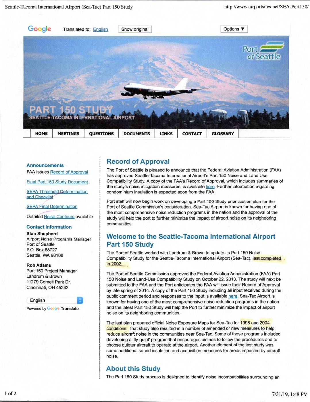
Seattle-Tacoma International Airport (Sea-Tac) Part 150 study
The Seattle-Tacoma International Airport (Sea-Tac) Part 150 Noise and Land Use Compatibility Study, approved by the Port of Seattle Commission in October 2013 and later by the FAA, aims to identify and reduce aircraft noise impacts on surrounding communities. The study developed noise exposure maps for 2013 and projected 2018 conditions, evaluated air traffic control procedures, and considered land use controls to limit noise-sensitive development in high-noise areas. Sea-Tac is recognized for having one of the most comprehensive airport noise reduction programs in the nation, with measures including a 'fly-quiet' program and sound insulation assistance for affected residents. -
 2019-07-31
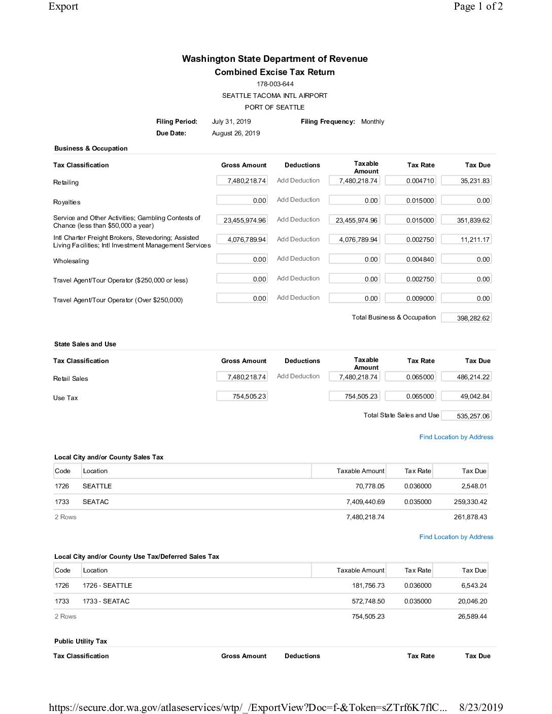
Combined Excise Tax Return: Seattle Tacoma Intl Airport, Port Of Seattle — July 2019
This document is a Washington State Combined Excise Tax Return filed by the Port of Seattle for Seattle-Tacoma International Airport, covering the period ending July 31, 2019. It reports Business & Occupation, State Sales and Use, Local Sales and Use, and Public Utility taxes across multiple classifications, resulting in a total tax liability of $1,348,574.66. The return was submitted on August 23, 2019, by Bonnie McArthur and paid via ACH debit with an effective date of August 26, 2019. -
 2019-07-31
Sound mitigation briefing: Highline Forum
This July 2019 briefing presented to the Highline Forum outlines Sea-Tac Airport's sound mitigation efforts under the FAA's Part 150 program, a voluntary federal framework that helps airports address noise and land use conflicts while qualifying for up to 80% federal grant funding. Sea-Tac's program, which began in 1985 and has undergone three updates (most recently in 2014), has involved extensive public outreach including workshops, city council presentations, and community forums. The briefing highlights that Sea-Tac Airport has been actively working to reduce aviation noise impacts on surrounding communities for more than 30 years. -
 2019-07-24
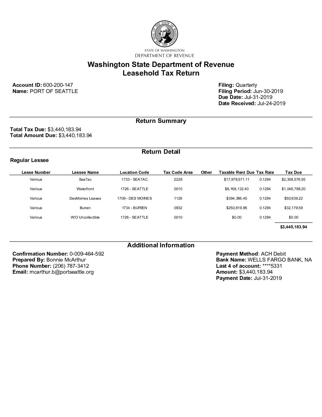
Washington State Department of Revenue Leasehold Tax Return: Port Of Seattle, Q2 2019
This Washington State Department of Revenue Leasehold Tax Return, filed by the Port of Seattle for the quarter ending June 30, 2019, reports a total tax due of $3,440,183.94. The largest portion—$2,308,576.93—stems from leases at Seattle-Tacoma International Airport (SeaTac), based on taxable rent of nearly $18 million at a rate of 12.84%. Additional leasehold taxes were assessed on Port properties in Seattle's waterfront, Des Moines, and Burien, with payment processed via ACH debit through Wells Fargo Bank on July 31, 2019. -
 2019-07-23
Preface and summary of themes in comparison matrix
The Burien Quiet Skies coalition compiled this 2019 document comparing FAA and Port of Seattle noise abatement commitments against actual progress, revealing decades of unmet promises dating back to 1985. Key concerns include hundreds of homes left uninsulated or poorly insulated, a 12-year gap in required noise modeling data, and noise levels in some Burien neighborhoods now exceeding the 65 dB threshold that triggers mitigation eligibility. The document calls on the FAA to hold the Port of Seattle accountable for failing to implement long-recommended noise reduction measures and for significantly underestimating flight operations and their impact on surrounding communities. -
 2019-07-23
Aviation Capital Planning & Preliminary Design Action Item: July 23, 2019
A July 23, 2019 Port of Seattle briefing document outlines the aviation capital planning and preliminary design process for Sea-Tac Airport, covering three phases: completed master planning, advanced planning still in progress, and preliminary design requiring capital funds approval. Key topics include near-term projects, projects requiring preliminary design authorization, and the relocation of a Glideslope Antenna. The preliminary design phase aims to develop individual project programs in sufficient detail to produce a Project Definition Document (PDD) and transition projects into full design. -
 2019-07-15
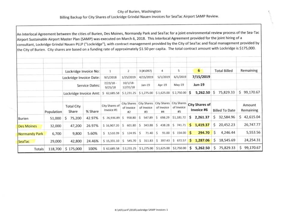
Billing Backup for City Shares of Lockridge Grindal Nauen Invoices for Sea-Tac Airport SAMP Review
This document details billing records from law firm Lockridge Grindal Nauen PLLP for legal services related to the Sea-Tac Airport Sustainable Airport Master Plan (SAMP) environmental review. Under a 2018 Interlocal Agreement, the cities of Burien, Des Moines, Normandy Park, and SeaTac jointly hired the firm at approximately $1.50 per capita, sharing costs based on population, against a total contract of $175,000. Invoice #6, dated July 15, 2019, covers 26 hours of work performed in June 2019 for a total of $5,262.50, with Burien's share amounting to $2,261.37. -
 2019-07-15
Billing Backup for City Shares of Lockridge Grindal Nauen Invoices for Sea-Tac Airport SAMP Review
This document details billing records from law firm Lockridge Grindal Nauen PLLP for legal services related to the Sea-Tac Airport Sustainable Airport Master Plan (SAMP) environmental review. Under a 2018 Interlocal Agreement, the cities of Burien, Des Moines, Normandy Park, and SeaTac jointly hired the firm at approximately $1.50 per capita, sharing costs based on population, against a total contract of $175,000. Invoice #6, dated July 15, 2019, covers 26 hours of work performed in June 2019 for a total of $5,262.50, with Burien's share amounting to $2,261.37. -
 2019-07-04
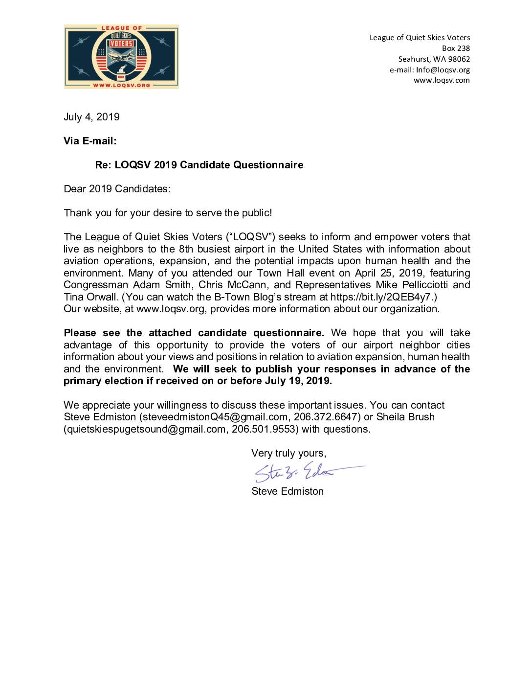
LOQSV 2019 Candidate Questionnaire Cover Letter
The League of Quiet Skies Voters (LOQSV), a Seahurst, WA-based organization focused on aviation noise and its impacts on health and the environment near Sea-Tac Airport, sent a candidate questionnaire to 2019 election candidates on July 4, 2019. The letter invited candidates to share their positions on aviation expansion, human health, and environmental concerns, with responses to be published before the primary election if submitted by July 19, 2019. LOQSV described itself as an advocate for communities neighboring the 8th busiest airport in the United States. -
 2019-06-30
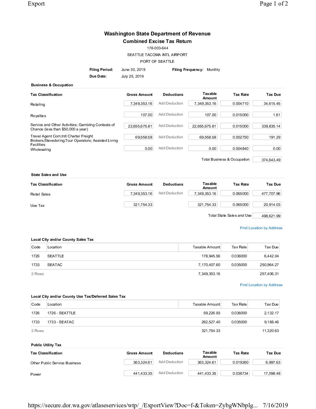
Combined Excise Tax Return: Seattle Tacoma International Airport, Port Of Seattle — June 2019
This document is a Washington State Combined Excise Tax Return filed by the Port of Seattle for Seattle-Tacoma International Airport, covering the period ending June 30, 2019. It details Business & Occupation, Sales and Use, and Public Utility taxes across multiple classifications, with a total tax liability of $1,177,641.02. The return was submitted on July 16, 2019, by Bonnie McArthur, with payment of $1,177,641.02 scheduled via ACH Debit on July 25, 2019.