TagSea-Tac Airport(1835)
-
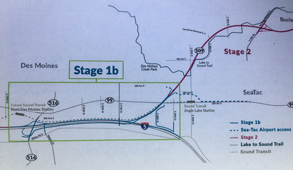
SR509 Completion Project I-5 Connector Overview
A planning map showing Stage 1b and Stage 2 alignments of the Lake to Sound Trail in the Des Moines and SeaTac, Washington area. Key landmarks labeled include Des Moines Creek Park, Sound Transit Angle Lake Station, the Future Sound Transit Kent/Des Moines Station, SR-509, SR-516, SR-99, and I-5, with trail segments distinguished by color-coded legend lines including Sea-Tac Airport access routes. -
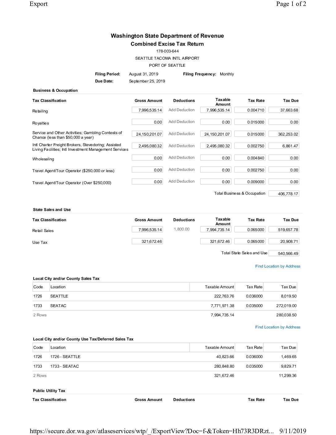 2019-08-31
Port Of Seattle: Combined Excise Tax Return for Seattle Tacoma Intl Airport — August 2019
This document is a Washington State Combined Excise Tax Return filed by the Port of Seattle for Seattle-Tacoma International Airport, covering the period ending August 31, 2019. It details Business & Occupation taxes, state and local sales and use taxes, and public utility taxes across multiple categories, totaling $1,279,242.02 in taxes due. The return was submitted on September 11, 2019, by Bonnie McArthur and paid via ACH debit with an effective date of September 25, 2019. -
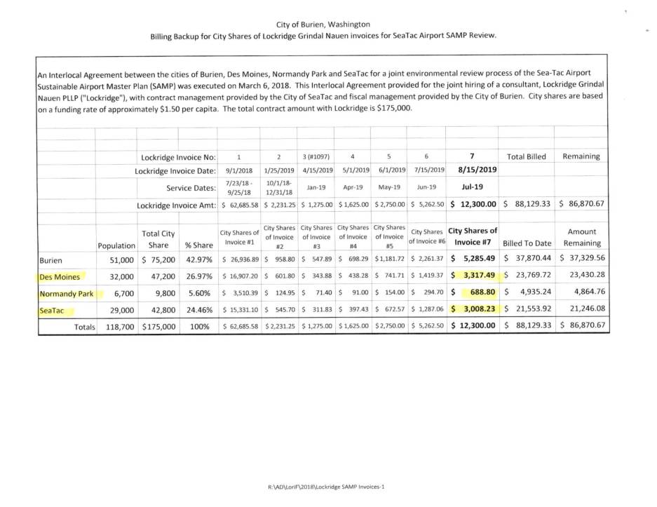 2019-08-15
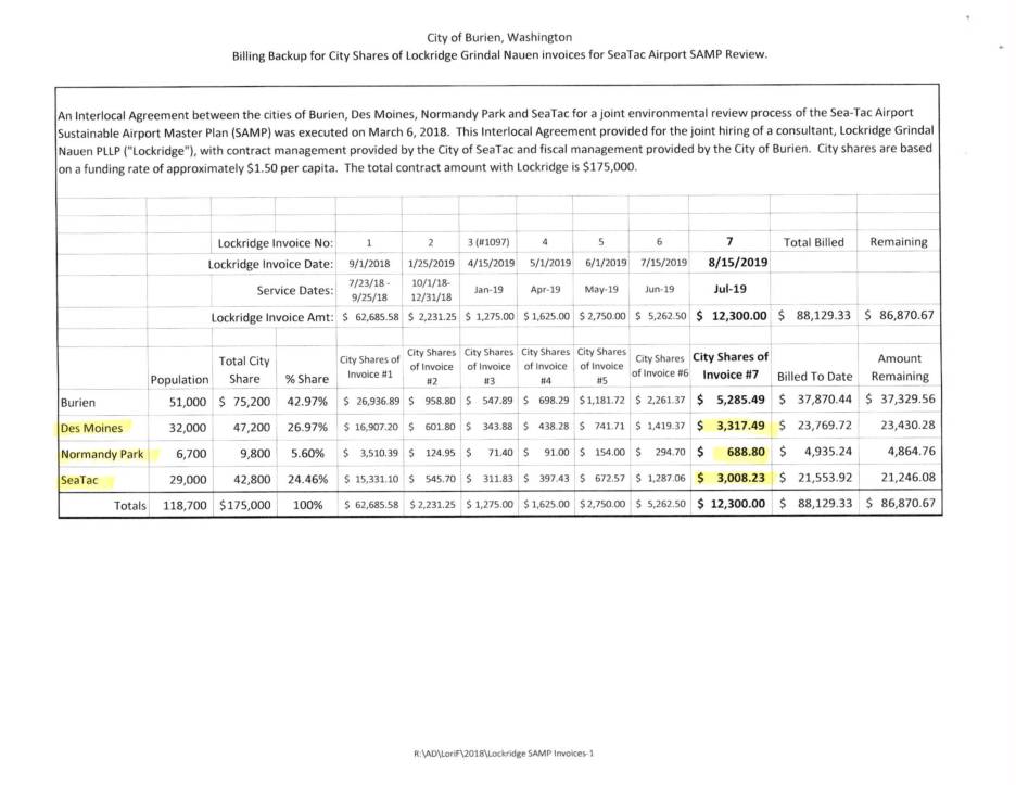
Billing Backup for City Shares of Lockridge Grindal Nauen Invoices for Sea-Tac Airport SAMP Review
This document details billing records from Lockridge Grindal Nauen P.L.L.P., a law firm hired jointly by the cities of Burien, Des Moines, Normandy Park, and SeaTac to review the Sea-Tac Airport Sustainable Airport Master Plan (SAMP). Under an Interlocal Agreement executed in March 2018, each city's share of the $175,000 total contract was calculated based on population at approximately $1.50 per capita. Invoice #7, dated August 15, 2019, covers legal services performed in July 2019 totaling $12,300, which included reviewing airspace modeling reports, analyzing client priorities, and preparing feedback on Port presentations. -
 2019-08-15
Billing Backup for City Shares of Lockridge Grindal Nauen Invoices for Sea-Tac Airport SAMP Review
This document details billing records from Lockridge Grindal Nauen P.L.L.P., a law firm hired jointly by the cities of Burien, Des Moines, Normandy Park, and SeaTac to review the Sea-Tac Airport Sustainable Airport Master Plan (SAMP). Under an Interlocal Agreement executed in March 2018, each city's share of the $175,000 total contract was calculated based on population at approximately $1.50 per capita. Invoice #7, dated August 15, 2019, covers legal services performed in July 2019 totaling $12,300, which included reviewing airspace modeling reports, analyzing client priorities, and preparing feedback on Port presentations. -
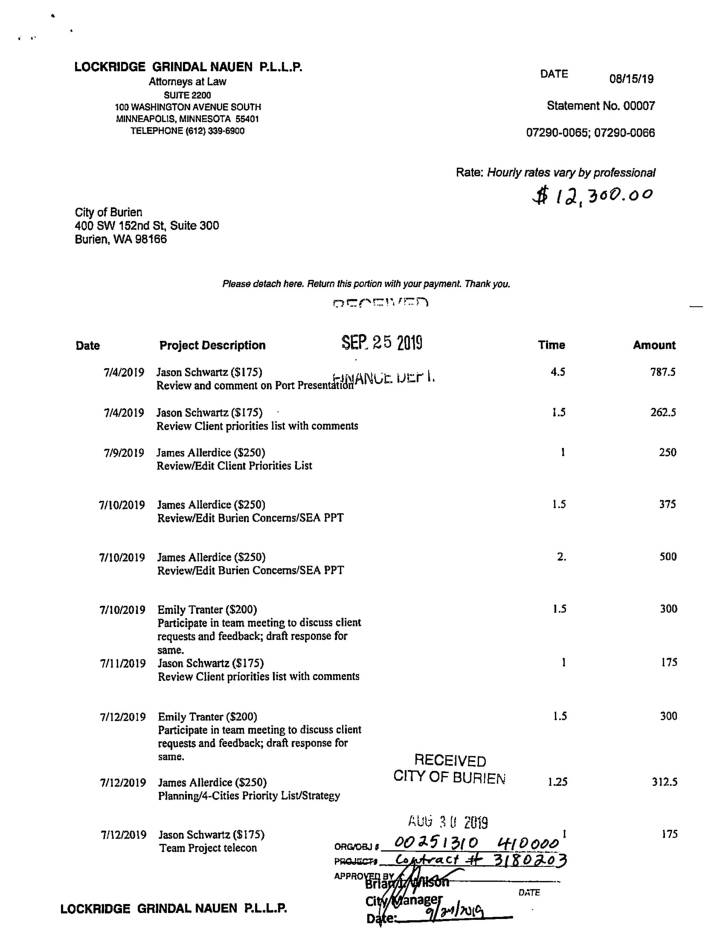 2019-08-15
Lockridge Grindal Nauen PLLP Invoice No. 7: City of Burien SAMP Legal Services, July 2019
This document contains a July 2019 legal billing statement from Lockridge Grindal Nauen P.L.L.P. to the City of Burien for $12,300, covering attorney work related to the Sea-Tac Airport Sustainable Airport Master Plan (SAMP) environmental review. The work included reviewing airspace modeling reports, Port presentations, and client priority lists. The billing is part of a broader Interlocal Agreement among Burien, Des Moines, Normandy Park, and SeaTac, with costs shared among the four cities based on population, under a total $175,000 contract. -
 2019-08-15
Billing Backup for City Shares of Lockridge Grindal Nauen Invoices for Sea-Tac Airport SAMP Review
The City of Burien, Washington contracted law firm Lockridge Grindal Nauen PLLP to review the Sea-Tac Airport Sustainable Airport Master Plan (SAMP) under a joint interlocal agreement with the cities of Des Moines, Normandy Park, and SeaTac. Costs were shared among the four cities based on population, at approximately $1.50 per capita, against a total contract value of $175,000. As of invoice #7 (August 2019), a total of $88,129.33 had been billed, leaving approximately $86,870.67 remaining on the contract. -
 2019-08-15
Lockridge Grindal Nauen PLLP Invoice No. 7: City of Burien SAMP Legal Services, July 2019
This document contains a July 2019 legal billing statement from Lockridge Grindal Nauen P.L.L.P. to the City of Burien for $12,300, covering attorney work related to the Sea-Tac Airport Sustainable Airport Master Plan (SAMP) environmental review. The work included reviewing airspace modeling reports, Port presentations, and client priority lists. The billing is part of a broader Interlocal Agreement among Burien, Des Moines, Normandy Park, and SeaTac, with costs shared among the four cities based on population, under a total $175,000 contract. -
 2019-08-15
Billing Backup for City Shares of Lockridge Grindal Nauen Invoices for Sea-Tac Airport SAMP Review
The City of Burien, Washington contracted law firm Lockridge Grindal Nauen PLLP to review the Sea-Tac Airport Sustainable Airport Master Plan (SAMP) under a joint interlocal agreement with the cities of Des Moines, Normandy Park, and SeaTac. Costs were shared among the four cities based on population, at approximately $1.50 per capita, against a total contract value of $175,000. As of invoice #7 (August 2019), a total of $88,129.33 had been billed, leaving approximately $86,870.67 remaining on the contract. -
 2019-08-07
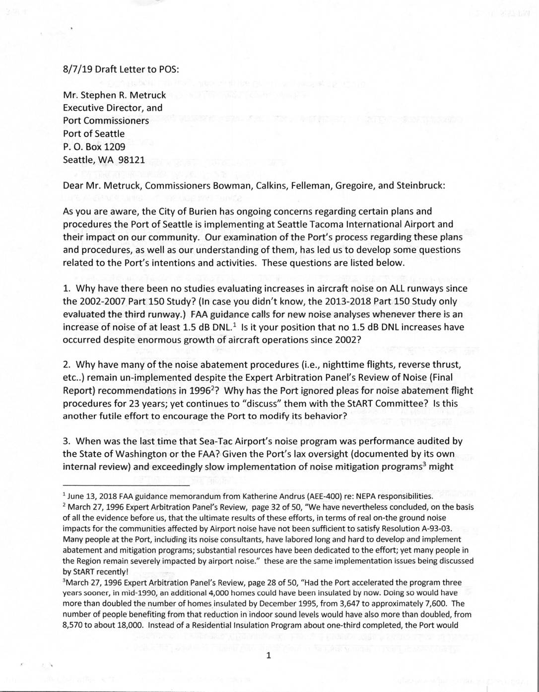
Draft letter to Port Of Seattle regarding Sea-Tac Airport noise and community impact concerns
In August 2019, the City of Burien sent a draft letter to the Port of Seattle raising eight pointed questions about Seattle-Tacoma International Airport's handling of aircraft noise, air quality, and community impact. The letter challenges the Port's failure to conduct comprehensive noise studies since 2002, its slow implementation of sound insulation programs, and its prioritization of airport expansion planning over legally recommended noise mitigation measures. Burien officials conclude that the Port has not treated compatibility with surrounding communities as a genuine priority, citing decades of unaddressed recommendations dating back to a 1996 Expert Arbitration Panel report. -
At Sea-Tac airport, a red border made of sand draws attention to human trafficking
The Border US-MX installation can be viewed by plane passengers overhead and light rail commuters. by Agueda Pacheco Flores The red sand is shaped in the form of the southern border that divides the U.S. from Mexico. It took nearly 2.6 tons of red sand to build the 350-foot-long line. (Courtesy of Molly Gochman/The StoryMakers) As