TagSAMP(650)
Articles tagged with the Sustainable Airport Master Plan.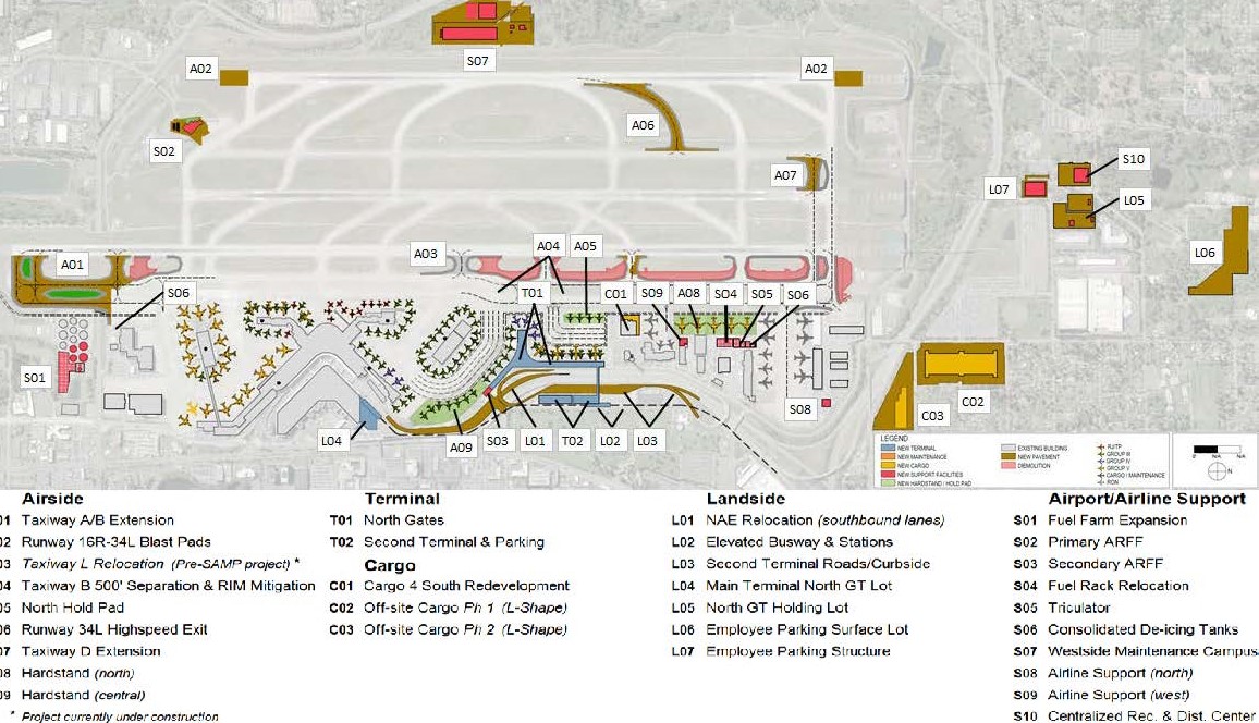
-
 2015-12-15
Sea-Tac Airport Sustainability Goals and Objectives
A December 2015 presentation by Sea-Tac Airport's Director of Environmental & Planning outlines how the airport is weaving sustainability into its Master Plan across three phases: what and where it builds, how it builds, and how it operates. The plan is guided by the Port of Seattle's Century Agenda and the airport's own Strategy for a Sustainable Sea-Tac (S3), with development concepts for airfield, terminal, and landside areas being screened against sustainability-based evaluation criteria. Key planning constraints include meeting passenger demand growth without adding new runways, improving airfield efficiency through NextGen technology, and converting sustainability goals into measurable decision-making criteria. -
 2015-09-15
Letter of understanding regarding the environmental review of the Sustainable Airport Master Plan
In this September 2015 letter, the Port of Seattle and the City of SeaTac reached a mutual agreement regarding the environmental review of Sea-Tac Airport's Sustainable Airport Master Plan (SAMP). The Port committed to conducting a full environmental analysis of all anticipated airport growth — including international passenger traffic — as part of the SAMP review process, addressing the City's concerns about transportation and other impacts. In exchange, the City agreed not to file an appeal on the Final Declaration of Non-Significance issued for the International Arrivals Facility project. -
 2015-09-01
Technical Memorandum No. 4: Forecasts of Aviation Activity, Seattle-Tacoma International Airport
This September 2015 technical report, prepared by Leigh Fisher for the Port of Seattle, provides long-range forecasts of aviation activity at Seattle-Tacoma International Airport as part of the Sustainable Airport Master Plan. It examines historical and projected trends in enplaned passengers, air cargo, and aircraft operations, drawing on regional socioeconomic data such as population growth, employment, and income in the Seattle-Tacoma area. The forecasts are intended to support future airport planning decisions, including infrastructure and capacity needs. -
Port of Seattle Reviews Designs for an Expanded International Arrivals Facility at Sea-Tac
Matt Ball on July 13, 2015 – in Design/Engineering, Projects, Transportation The Port of Seattle is in the conceptual design phase of an expanded International Arrivals Facility (IAF) at Seattle-Tacoma International Airport. With this 1970’s vintage facility in the south satellite servicing a dramatic increase in international flights, the existing Federal Inspections area (commonly known -
 2015-07-01
Technical Memorandum No. 1: Background, Process, Goals, and Objectives — Seattle-Tacoma International Airport Sustainable Airport Master Plan
This July 2015 technical memorandum outlines the background, goals, and objectives for Seattle-Tacoma International Airport's Sustainable Airport Master Plan (SAMP), prepared by Leigh Fisher for the Port of Seattle. It describes how the SAMP differs from a traditional airport master plan by integrating financial, environmental, and community sustainability considerations into long-term airport development planning. The document also explains how sustainability goals—drawn from national, regional, and Port of Seattle policies—will be used to evaluate and screen future development alternatives for Sea-Tac Airport. -
 2015-05-21
Sustainable Airport Master Plan (SAMP): City of Des Moines Council briefing
This May 2015 briefing presented the Port of Seattle's Sustainable Airport Master Plan (SAMP) for Seattle-Tacoma International Airport to the City of Des Moines Council. The plan addresses rapid passenger and operations growth within a constrained airport footprint, outlining the need for strategic land use planning, potential expansion onto additional Port-owned properties, and relocation of existing facilities to maintain airfield capacity and add terminal capacity. Key topics covered include economic impact, sustainability, activity forecasts, development constraints, and public outreach. -
 2015-03-25
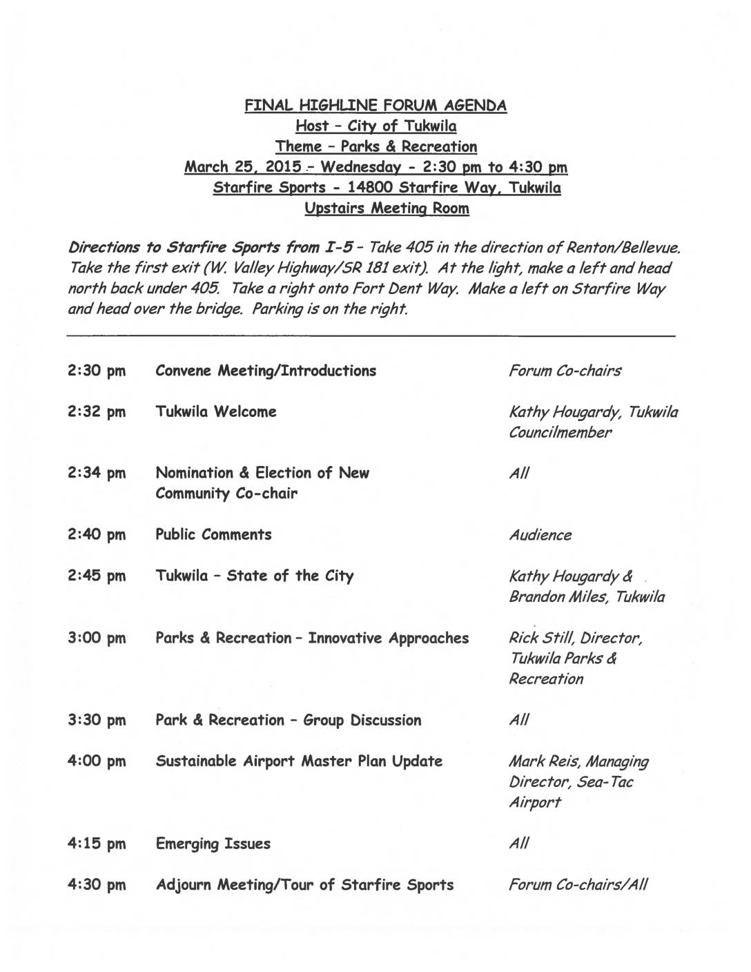
Highline Forum Agenda: Parks & Recreation — March 25, 2015
This document contains the agenda for the Highline Forum meeting held on March 25, 2015, hosted by the City of Tukwila at Starfire Sports. The two-hour meeting covered topics including Parks and Recreation innovative approaches, a State of the City address, and notably a Sustainable Airport Master Plan Update presented by Mark Reis, Managing Director of Sea-Tac Airport. The forum also included community discussions and the election of a new Community Co-chair. -
 2015-03-01
Technical Memorandum No. 2: Inventory of Existing Conditions — Seattle-Tacoma International Airport
This 2015 technical memorandum prepared by Leigh Fisher for the Port of Seattle provides a comprehensive inventory of existing conditions at Seattle-Tacoma International Airport as part of the Sustainable Airport Master Plan. It covers a wide range of airport infrastructure and operations, including airfield runways and taxiways, passenger terminal facilities, ground transportation, air cargo, general aviation, and airline and airport support systems. The document serves as a baseline assessment of the airport's physical and operational state to inform future planning decisions. -
 2014-05-01
Air Cargo Market Assessment: Seattle-Tacoma International Airport
This May 2014 technical report, prepared by Leigh Fisher and Webber Air Cargo, Inc. for the Port of Seattle, assesses the air cargo market at Seattle-Tacoma International Airport (Sea-Tac). It examines industry trends, carrier market shares, competing gateways, international trade flows, and the airport's cargo facilities and handling service providers. The report concludes with an outlook and recommendations to support future cargo growth at Sea-Tac. -
 2012-12-24
Sea-Tac Awarded $750,000 FAA Grant for Airport Sustainability Master Plan
FAA recently awarded the Port of Seattle a $750,000 grant to integrate sustainability into the next master plan for Seattle-Tacoma International. The port commission last week approved $6 million for the creation of a new airport sustainability master plan that will provide a long-term blueprint for airport development to meet the needs of the traveling