TagSea-Tac Airport(1835)
-
 2020-01-15
City of Burien Billing Backup for City Shares of Lockridge Grindal Nauen Invoices for Sea-Tac Airport SAMP Review
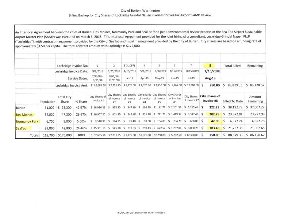
This document details billing records for the City of Burien, Washington, related to the Sea-Tac Airport Sustainable Airport Master Plan (SAMP) environmental review. Four cities — Burien, Des Moines, Normandy Park, and SeaTac — jointly hired law firm Lockridge Grindal Nauen PLLP under a $175,000 contract, with each city's share calculated at approximately $1.50 per capita. Through eight invoices spanning 2018 to early 2020, a total of $88,879.33 had been billed, leaving a remaining balance of $86,120.67. -
 2020-01-15
Billing Backup for City Shares of Lockridge Grindal Nauen Invoices for Sea-Tac Airport SAMP Review
The City of Burien, Washington maintained billing records for a joint legal consulting contract with Lockridge Grindal Nauen PLLP to review the Sea-Tac Airport Sustainable Airport Master Plan (SAMP). Four cities — Burien, Des Moines, Normandy Park, and SeaTac — shared the $175,000 contract cost based on their respective populations, at approximately $1.50 per capita. By January 2020, a total of $88,879.33 had been billed across eight invoices, leaving a remaining balance of $86,120.67. -
 2020-01-15
Billing Backup for City Shares of Lockridge Grindal Nauen Invoices for Sea-Tac Airport SAMP Review
The City of Burien, Washington maintained billing records for a joint legal consulting contract with Lockridge Grindal Nauen PLLP to review the Sea-Tac Airport Sustainable Airport Master Plan (SAMP). Four cities — Burien, Des Moines, Normandy Park, and SeaTac — shared the $175,000 contract cost based on their respective populations, at approximately $1.50 per capita. By January 2020, a total of $88,879.33 had been billed across eight invoices, leaving a remaining balance of $86,120.67. -
 2020-01-01
Understanding the health effects of jet pollution around Sea-Tac Airport
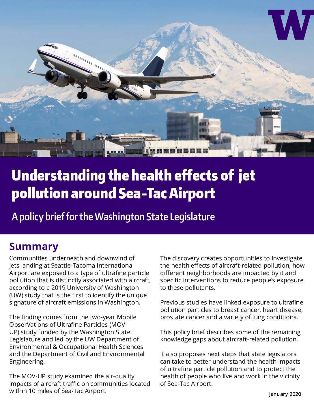
A 2019 University of Washington study found that communities within 10 miles of Seattle-Tacoma International Airport are exposed to ultrafine particle pollution uniquely linked to aircraft emissions, distinct from roadway traffic pollution. These microscopic particles — 700 times thinner than a human hair — are not currently regulated by federal or state air-quality standards, and prior research has associated them with breast cancer, heart disease, prostate cancer, and lung conditions. The policy brief calls on Washington State legislators to fund a follow-up two-year study to investigate the health impacts on nearby communities, which tend to be poorer and more racially diverse than King County as a whole. -
 2020-01-01
SEA Stakeholder Advisory Round Table 2020 annual report
The SEA Stakeholder Advisory Round Table (StART) 2020 Annual Report, presented by Port of Seattle staff and a consultant, outlines the group's activities and achievements for the year, including work by the Aviation Noise Working Group and the Federal Policy Working Group. The report covers 2020 highlights and accomplishments, facilitator reflections, and tentative priorities for 2021 meetings. StART serves as a community advisory forum focused on addressing aviation noise and related policy concerns at Seattle-Tacoma International Airport. -
 2019-12-31
Combined Excise Tax Return: Seattle Tacoma International Airport, Port Of Seattle — December 2019
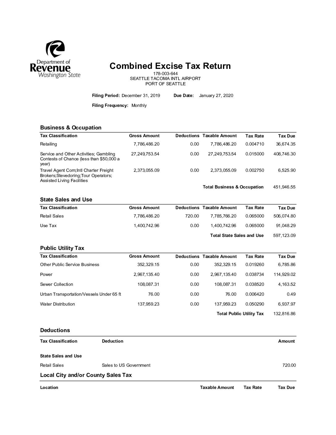
This is a Combined Excise Tax Return filed by the Port of Seattle for Seattle-Tacoma International Airport, covering the period ending December 31, 2019, with a due date of January 27, 2020. The document details taxes owed across several categories, including Business & Occupation tax, State Sales and Use tax, and Public Utility tax, totaling $1,503,786.56. Payment was submitted on January 23, 2020 via ACH Debit/E-Check by Port of Seattle staff member Bonnie McArthur. -
 2019-12-31
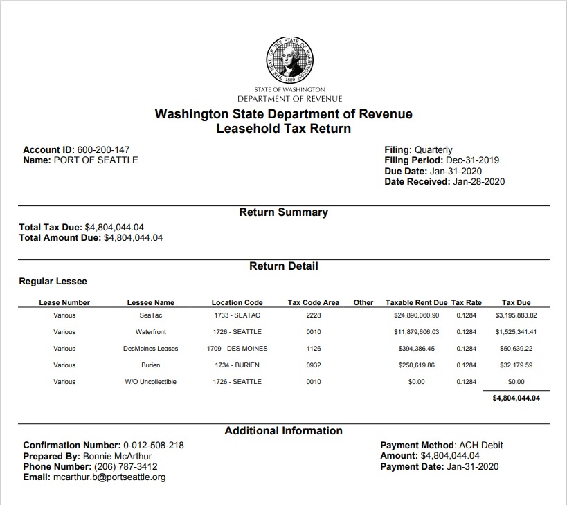
Washington State Department of Revenue Leasehold Tax Return – Port Of Seattle, Q4 2019
This is a Washington State Department of Revenue Leasehold Tax Return (Account ID 600-200-147) filed by the Port of Seattle for the quarterly filing period ending Dec-31-2019, with a total tax due of $4,804,044.04. The return details taxable rent across multiple locations including SeaTac (Location Code 1733), with the largest tax due of $3,195,883.82 on $24,890,060.90 in taxable rent, submitted via ACH Debit on Jan-31-2020. -
 2019-12-31
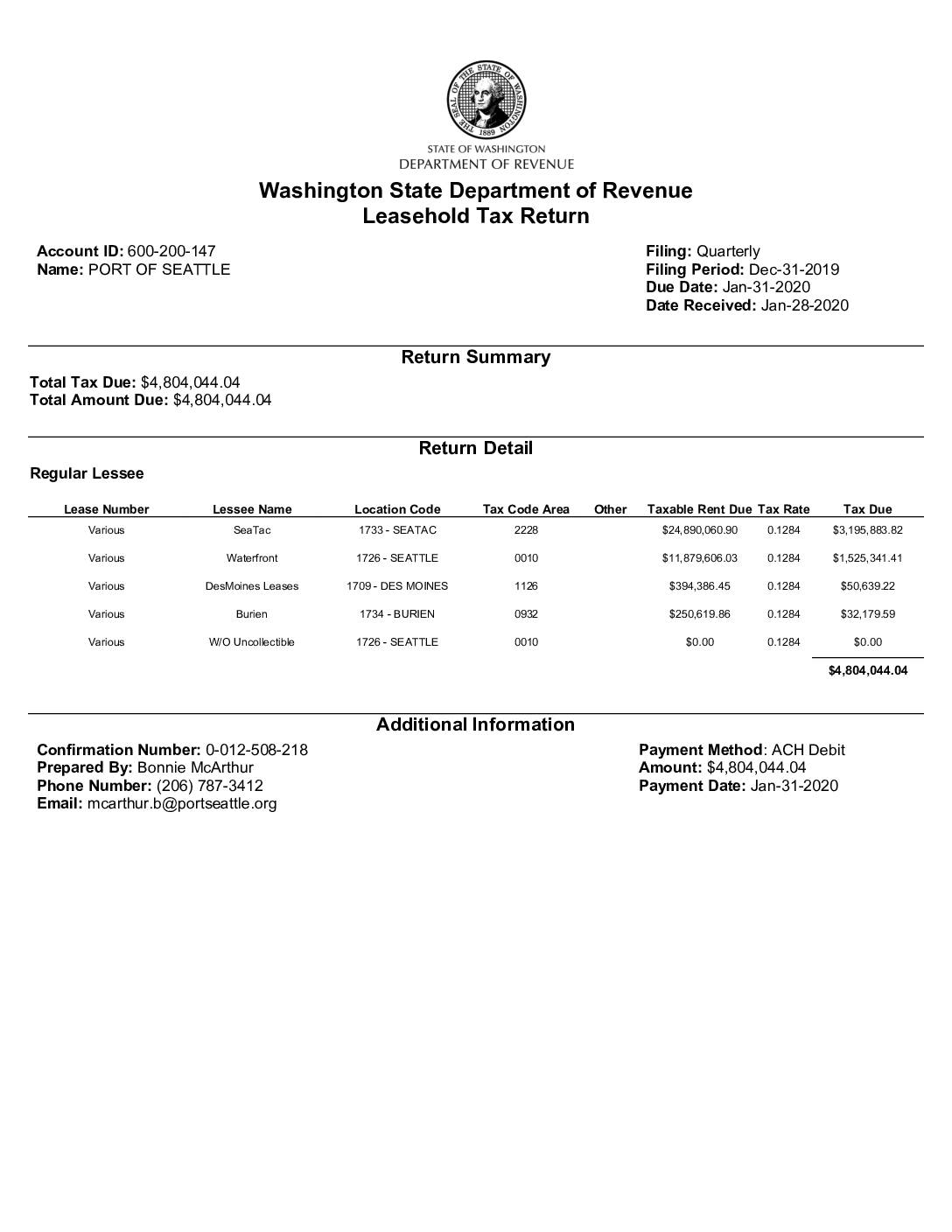
Washington State Department of Revenue Leasehold Tax Return: Port Of Seattle, Q4 2019
The Port of Seattle filed a Washington State Leasehold Tax Return for the quarter ending December 31, 2019, reporting a total tax due of $4,804,044.04. The largest portion—$3,195,883.82—was generated from SeaTac leases with taxable rent of approximately $24.9 million, alongside additional revenue from Waterfront, Des Moines, and Burien locations. Payment of the full amount was submitted via ACH Debit on January 31, 2020, one day before the deadline. -
 2019-12-17
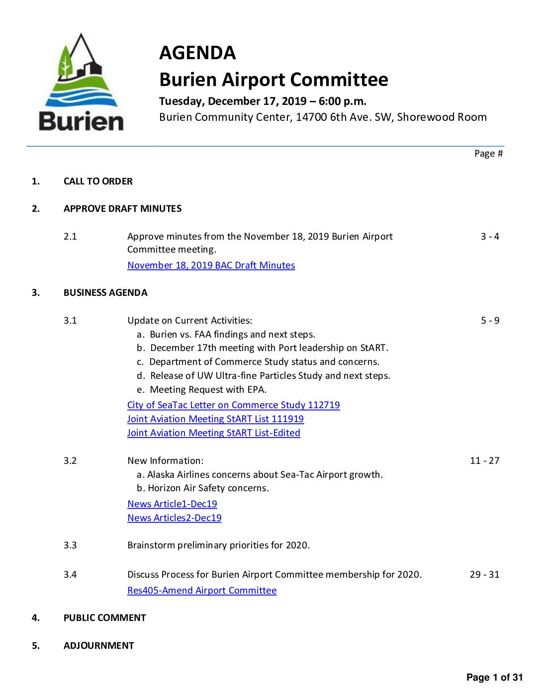
Burien Airport Committee agenda, December 17, 2019
The Burien Airport Committee met on December 17, 2019 to discuss ongoing concerns related to Sea-Tac Airport, including the city's legal findings against the FAA, the status of a University of Washington ultrafine particles study, and safety issues raised by Alaska Airlines and Horizon Air. The committee also reviewed progress on the Sea-Tac Stakeholder Advisory Round Table (StART) and a Washington State Department of Commerce study, while planning priorities for 2020. Draft minutes from the November 18, 2019 meeting were included, detailing earlier discussions on noise reduction, environmental impacts, and a potential meeting with the EPA. -
 2019-12-11
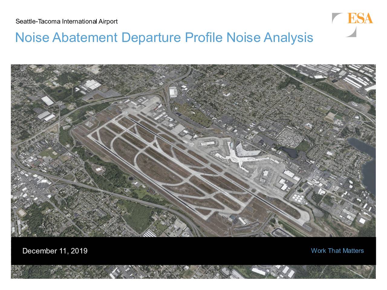
Seattle-Tacoma International Airport noise abatement departure profile noise analysis
This December 2019 report by ESA for the Port of Seattle analyzes two standard Noise Abatement Departure Profiles (NADPs) used at Seattle-Tacoma International Airport: the Close-in profile, which reduces noise near the runway end, and the Distant profile, which reduces noise farther along the departure path. The analysis finds that the Distant NADP provides the greatest noise relief to the residential and developed communities surrounding Sea-Tac Airport. The report includes background on departure profiles, noise analysis results, and recommendations for the airport's noise abatement policy.