TagSea-Tac Airport(1835)
-
 2022-05-19
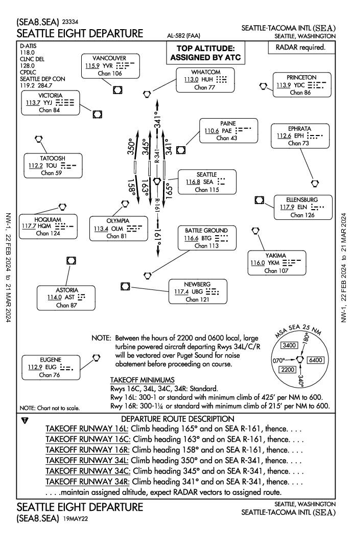
Seattle Eight Departure (SEA8.SEA) — Standard Instrument Departure Chart
The Seattle Eight Departure (SEA8.SEA) is a standard instrument departure procedure for Seattle-Tacoma International Airport, outlining specific climb headings and routes for each runway to guide aircraft safely after takeoff. A notable noise-abatement provision requires large turbine-powered aircraft departing runways 34L, 34C, and 34R between 10 PM and 6 AM local time to be vectored over Puget Sound before proceeding on course. The procedure requires radar and assigns top altitude by ATC, with special minimum climb gradients applicable to runways 16R and 16L. -
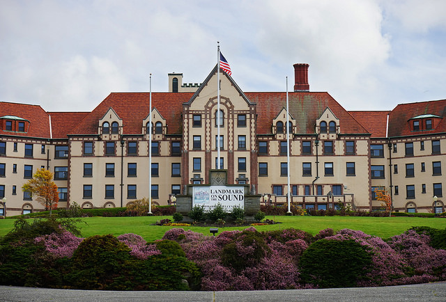
Masonic Home of Des Moines, Washington (Now Landmark on the Sound)
The image shows the Landmark on the Sound facility, a large historic building with red tile roofs, an American flag, and a clearly visible sign reading 'Landmark on Sound.' This property is located near Renton, Washington, in the Sea-Tac Airport noise impact area and has been associated with discussions about airport noise mitigation and land use planning. -
 2022-04-12
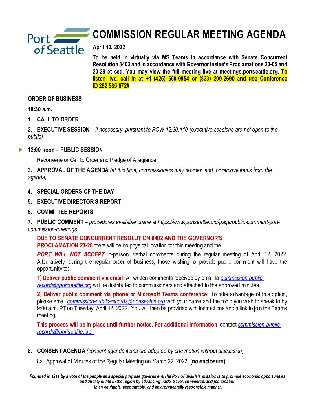
Port Of Seattle commission regular meeting agenda
The Port of Seattle Commission held a virtual regular meeting on April 12, 2022, covering airport-related capital projects including a briefing on the C Concourse Expansion Project and authorization requests for construction contracts at Seattle-Tacoma International Airport. The agenda also included a Sound Transit briefing on the West Seattle and Ballard Link Extensions Draft Environmental Impact Statement, which touches on the Ballard/Interbay corridor near port facilities. Public comment was accepted by email or phone only, with no in-person attendance permitted under Governor Inslee's pandemic proclamations. -
 2022-04-01
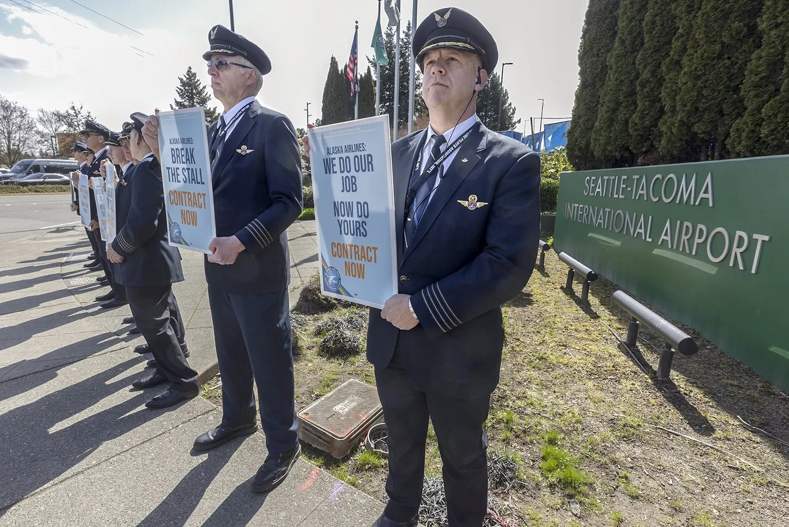
Alaska Airline Pilots on strike 04/01/2022
Alaska Airlines pilots in uniform hold protest signs reading 'Alaska Airlines: Break the Stall – Contract Now' and 'Alaska Airlines: We Do Our Job, Now Do Yours – Contract Now' outside Seattle-Tacoma International Airport. The demonstration reflects an ongoing labor dispute between Alaska Airlines pilots and management over contract negotiations. -
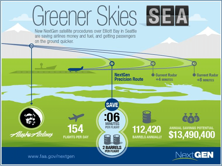
FAA-Greener-Skies-Initial-Benefits-of-RNPe-at-Seattle-International-Airport (1)
An FAA NextGen infographic promoting the 'Greener Skies' satellite precision navigation procedures over Elliott Bay at Seattle-Tacoma International Airport (SEA). It highlights Alaska Airlines' 154 daily flights saving 6 minutes per flight, 2 barrels of fuel per flight (112,420 barrels annually), and an annual savings potential of $13,490,400, sourced from www.faa.gov/nextgen. -
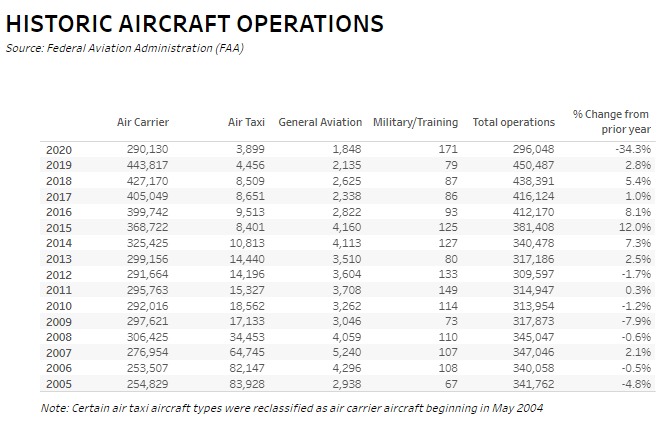
Tableau Historic Operations 2005-2020
A data table sourced from the Federal Aviation Administration (FAA) showing historic aircraft operations from 2005 to 2020, broken down by Air Carrier, Air Taxi, General Aviation, and Military/Training categories, along with total operations and percent change from prior year. The table shows a sharp -34.3% decline in total operations in 2020, dropping to 296,048, compared to 450,487 in 2019. -
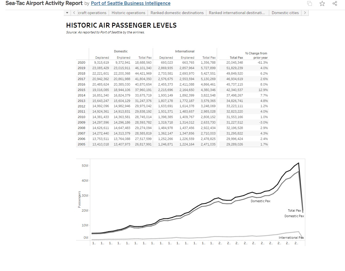
Tableau Historic Passenger Levels 2005-2020
A Port of Seattle Business Intelligence dashboard showing Sea-Tac Airport's historic air passenger levels from 2005 to 2020, broken down by domestic and international deplaned/enplaned totals. The report highlights a 61.3% decline in total passengers in 2020 (20,045,348) compared to a peak of 51,829,239 in 2019, reflecting the COVID-19 pandemic's impact on air travel. -
 2022-03-18
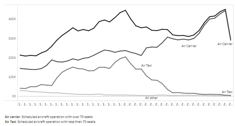
Tableau Operations Carrier vs. Taxi
A line chart showing scheduled aircraft operations over time for three categories: Air Carrier (aircraft with over 70 seats), Air Taxi (aircraft with less than 70 seats), and All Other. Air Carrier operations peak near 450K before declining sharply at the right end of the chart, while Air Taxi operations rise and then fall dramatically to near zero. -
 2022-01-26
Port & community provisions of the Infrastructure Investment & Jobs Act (IIJA)
This January 2022 briefing by Port of Seattle staff outlines how the federal Infrastructure Investment and Jobs Act (IIJA), signed by President Biden in November 2021, allocates $1.2 trillion across transportation and infrastructure priorities. Of particular relevance to the Port of Seattle, the law includes $20 billion for airports, $5 billion for FAA facilities and equipment, and $5.225 billion for seaports, alongside billions more in competitive grant programs that ports can apply for. The briefing was presented to the Highline Forum, a community body focused on issues related to Sea-Tac Airport and surrounding neighborhoods. -
 2022-01-19
International Arrivals Facility (IAF)
Seattle-Tacoma International Airport's new International Arrivals Facility (IAF), presented in January 2022, is a major expansion that increases the airport's international capable gates from 12 to 20 and replaces the old 87,000 sq. ft. facility with a spacious 450,000 sq. ft. building. The project also expanded baggage handling from 4 to 7 carousels using a 'Bags First' system, and supported over 10,000 construction jobs. This document provides an overview of the facility's key highlights and improvements to international passenger processing at Sea-Tac Airport.