Tagproperty(46)
-
 2014-12-31
FAA Tower lease information – Sea-Tac Airport
The FAA Tower at 2580 S 166th Street, SeaTac, WA 98158 is a Port of Seattle commercial lease (Lease #000224) covering approximately 99,626 square feet, with the tenant operating an FAA Air Traffic Control Tower (Building 17) on the property. The lease expired on 09/30/2019 but includes renewal options extending until 2079, with three available 20-year extensions and no holdover provisions. Any changes to the property's use are subject to bond restrictions and Airport Improvement Project (AIP) funding conditions, requiring coordination with Port of Seattle finance departments. -
 2014-12-31
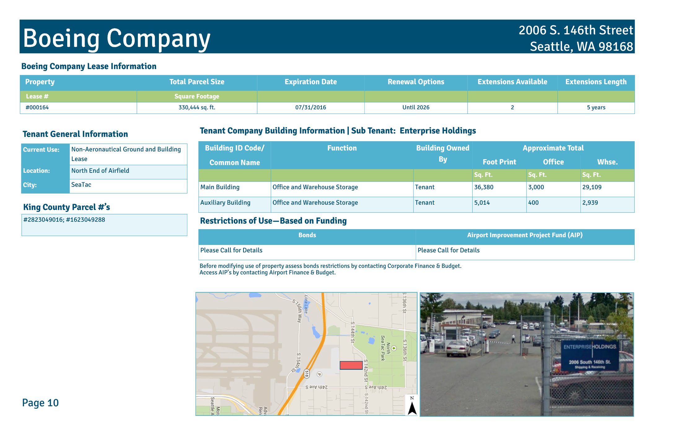
Boeing Company lease #000164 — 2006 S. 146th Street, Seattle, WA 98168
The Boeing Company holds a ground and building lease (#000164) at 2006 S. 146th Street in SeaTac, WA, covering approximately 330,444 square feet at the north end of Sea-Tac Airport's airfield. The lease, which expired in July 2016 with renewal options extending until 2026, includes two buildings used for office and warehouse storage, with Enterprise Holdings as a sub-tenant. The property is subject to bond and Airport Improvement Project (AIP) funding restrictions that govern any changes in its use. -
 2014-12-31
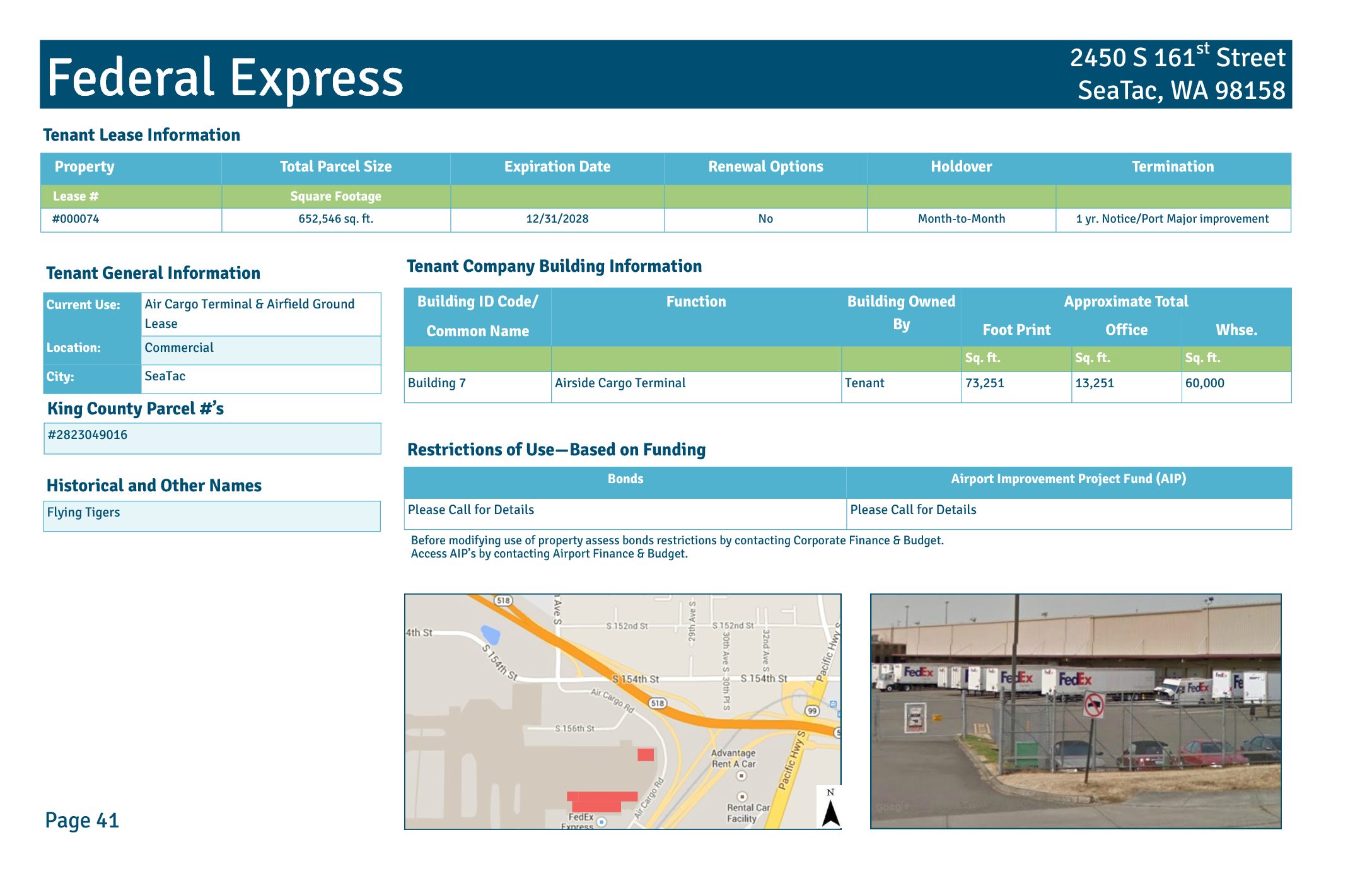
Federal Express lease information sheet — Sea-Tac Airport
Federal Express operates an Air Cargo Terminal and Airfield Ground Lease (Lease #000074) at 2450 S 161st Street in SeaTac, WA, covering a total parcel of 652,546 square feet with a lease expiration date of December 31, 2028. The facility, historically known as Flying Tigers, includes Building 7, an Airside Cargo Terminal with approximately 73,251 square feet of footprint, comprising 13,251 square feet of office space and 60,000 square feet of warehouse space. The property is subject to bond and Airport Improvement Project (AIP) funding restrictions, and any modifications to its use require consultation with Port of Seattle Corporate Finance & Budget and Airport Finance & Budget. -
 2014-12-31
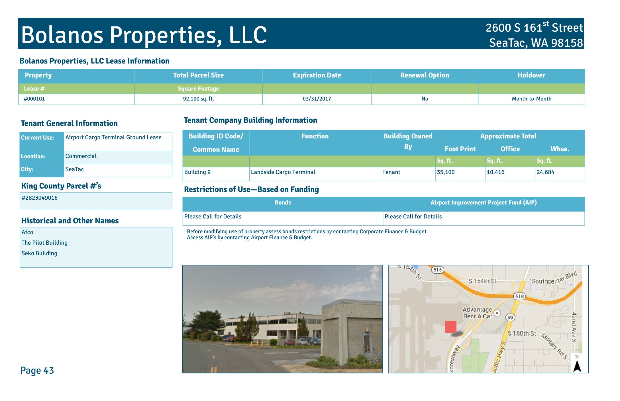
Bolanos Properties, LLC lease information
Bolanos Properties, LLC holds a ground lease (Lease #000101) at Seattle-Tacoma International Airport for a 92,190 sq. ft. parcel located at 2600 S 161st Street in SeaTac, WA, with a lease expiration date of March 31, 2017 and no renewal option, defaulting to month-to-month holdover. The property includes Building 9, a tenant-owned Landside Cargo Terminal spanning 35,100 sq. ft., with approximately 10,416 sq. ft. of office space and 24,684 sq. ft. of warehouse space. The site, historically known as the Afco, Pilot, and Seko buildings, is subject to bond and Airport Improvement Project (AIP) funding restrictions that must be reviewed before any change in use. -
 2014-12-31
Flying Food Fare lease and property information
Flying Food Fare operates a flight kitchen and office facility at 2300 S. 154th Street in SeaTac, WA, under a non-aeronautical ground lease (#000086) covering approximately 90,114 square feet at the north end of Sea-Tac Airfield. The lease, which expired in March 2018, included two renewal options extending until 2028, each lasting five years. The tenant-owned building spans roughly 34,199 square feet, with space divided between office and warehouse functions, and any modifications to the property's use require review of bond and Airport Improvement Project (AIP) funding restrictions. -
 2014-12-31
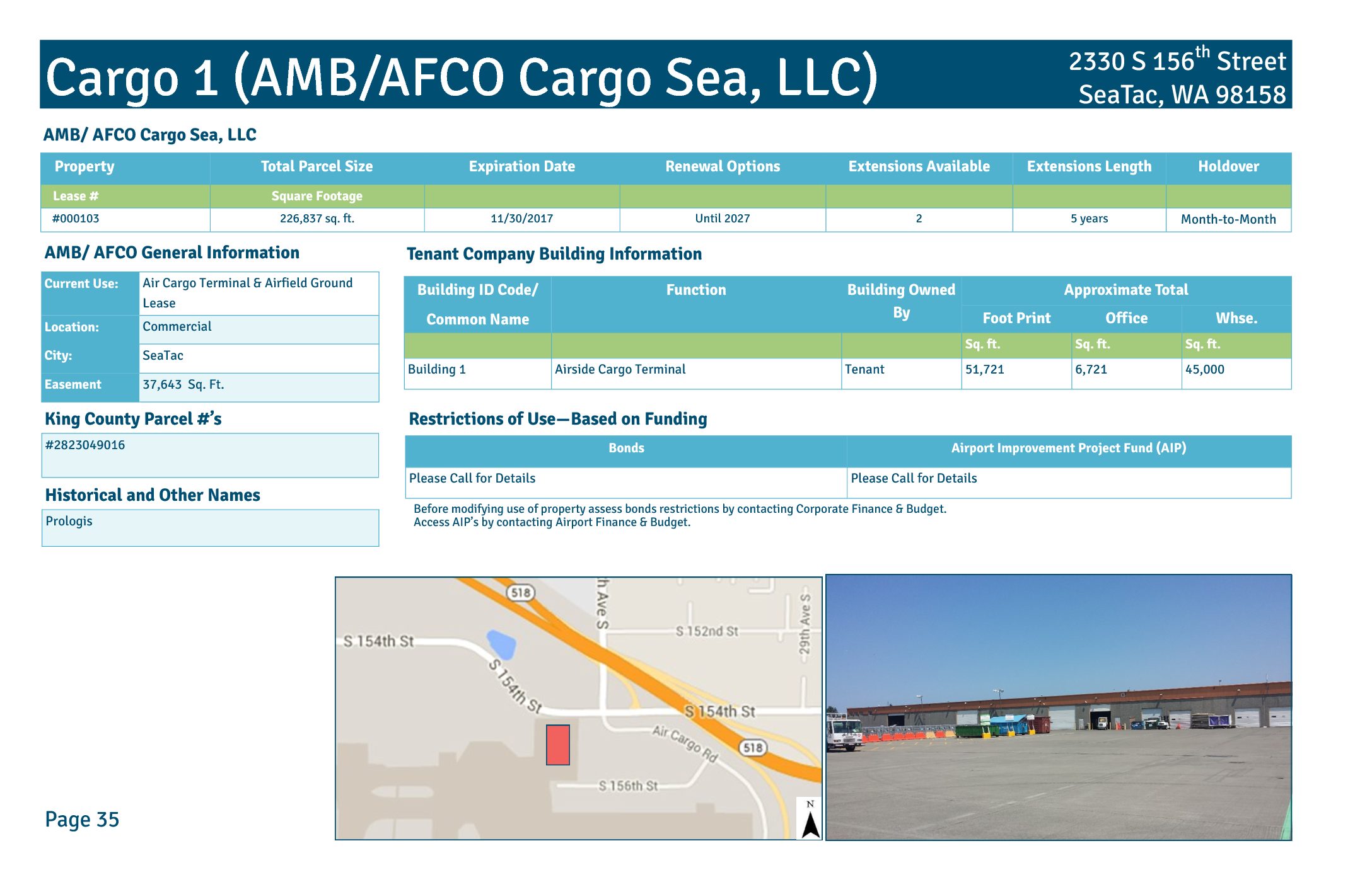
Cargo 1 (AMB/AFCO Cargo Sea, LLC) lease property profile
This document details Lease #000103 for Cargo 1, an air cargo terminal and airfield ground lease operated by AMB/AFCO Cargo Sea, LLC (historically known as Prologis) at 2330 S 156th Street, SeaTac, WA 98158. The property covers approximately 226,837 square feet, with Building 1 serving as an airside cargo terminal totaling 51,721 square feet, including 6,721 square feet of office space and 45,000 square feet of warehouse space. The lease, which expired November 30, 2017, includes renewal options extending until 2027, with two available five-year extensions and a month-to-month holdover provision. -
 2014-06-15
Airport Key Map: Sea-Tac Airport Property Zones
★ 32This Airport Key Map, published by the Port of Seattle on June 15, 2014, provides a general reference overview of property zones surrounding Seattle-Tacoma International Airport. It identifies distinct areas including the Airfield, Terminal, Commercial, South of Airfield, South of 200th, and North of Airfield zones, and distinguishes between Port of Seattle property, lease boundaries, non-Port property, land available for redevelopment, and the proposed SR 509 corridor. The aerial photo, taken in Spring 2012, is intended for general reference only and is not approved for navigation use. -
 1997-07-01
PSRC Property Acquisition Financial Feasibility Study
A study commissioned by the Puget Sound Regional Council to assess the financial feasibility of establishing a funding mechanism for acquiring and redeveloping properties adversely impacted by regionally significant essential public facilities. The study examines case study areas near the Auburn Rail Yard, Sea-Tac International Airport, and the proposed Everett 112th Street SE HOV Lanes -
 1985-09-01
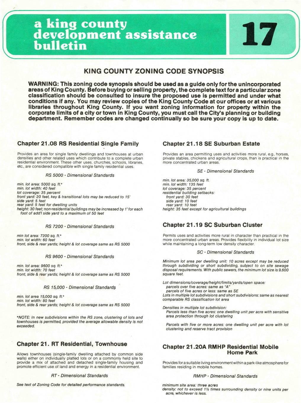
King County Zoning Code Synopsis
This King County Development Assistance Bulletin (No. 17, dated September 1985) provides a synopsis of zoning classifications for unincorporated areas of King County, Washington, covering residential, agricultural, and general land-use zones along with their dimensional standards such as minimum lot sizes, setbacks, height limits, and lot coverage. It includes a chapter on Airport Open Use (AOU) zoning, which governs development in areas affected by major airports to ensure compatibility with neighboring residential areas and airport clear zone requirements. The bulletin also outlines procedures for obtaining zoning information, requesting written verification, and applying for zone changes. -
 1979-04-10
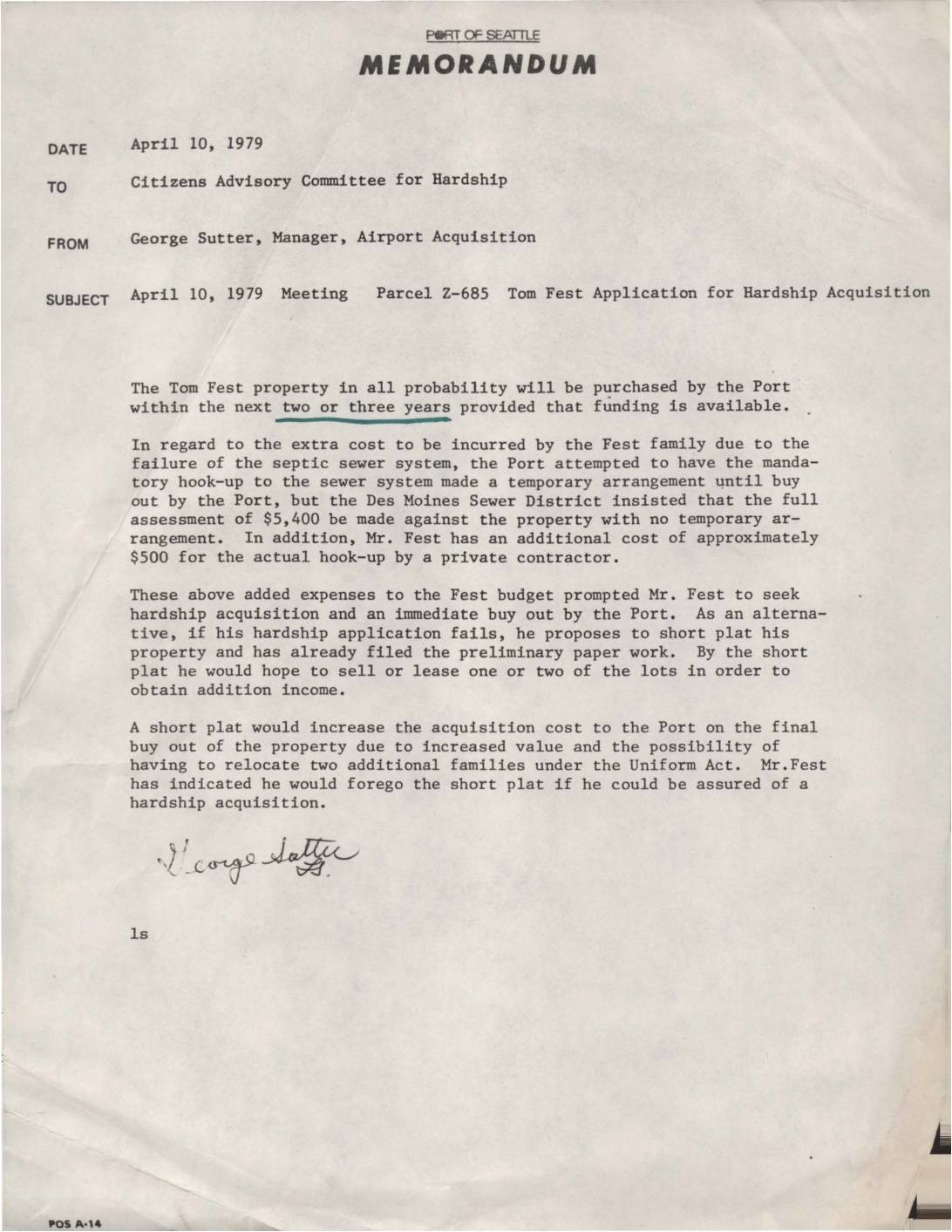
Tom Fest Application for Hardship Acquisition – Parcel Z-685
A 1979 Port of Seattle memo from Airport Acquisition Manager George Sutter to the Citizens Advisory Committee for Hardship outlines Tom Fest's application for hardship acquisition of his property (Parcel Z-685), prompted by unexpected sewer hook-up costs totaling approximately $5,900. The Port expected to purchase the property within two to three years, but the Fest family sought an immediate buyout due to financial strain. As an alternative, Mr. Fest threatened to subdivide the property via short plat — a move that would increase the Port's eventual acquisition costs — but indicated he would abandon that plan if hardship acquisition was approved.