TagSAMP(650)
Articles tagged with the Sustainable Airport Master Plan.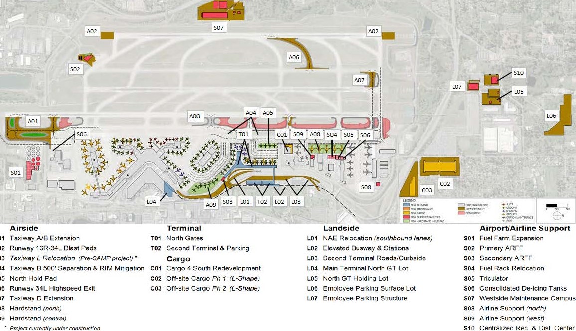
-
 2019-08-15
Billing Backup for City Shares of Lockridge Grindal Nauen Invoices for Sea-Tac Airport SAMP Review
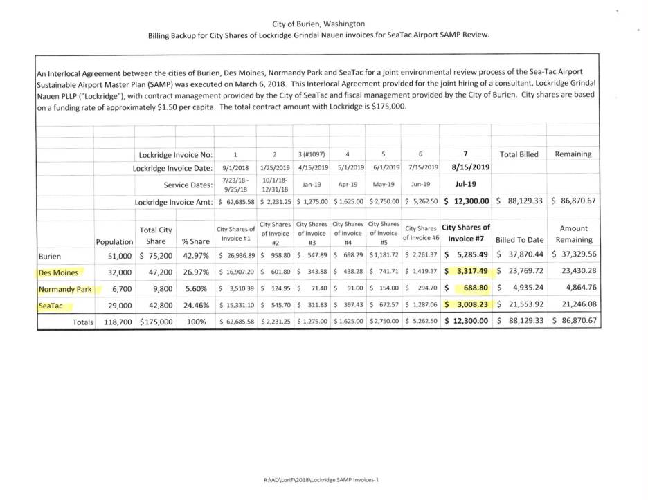
The City of Burien, Washington contracted law firm Lockridge Grindal Nauen PLLP to review the Sea-Tac Airport Sustainable Airport Master Plan (SAMP) under a joint interlocal agreement with the cities of Des Moines, Normandy Park, and SeaTac. Costs were shared among the four cities based on population, at approximately $1.50 per capita, against a total contract value of $175,000. As of invoice #7 (August 2019), a total of $88,129.33 had been billed, leaving approximately $86,870.67 remaining on the contract. -
 2019-08-15
Billing Backup for City Shares of Lockridge Grindal Nauen Invoices for Sea-Tac Airport SAMP Review
The City of Burien, Washington contracted law firm Lockridge Grindal Nauen PLLP to review the Sea-Tac Airport Sustainable Airport Master Plan (SAMP) under a joint interlocal agreement with the cities of Des Moines, Normandy Park, and SeaTac. Costs were shared among the four cities based on population, at approximately $1.50 per capita, against a total contract value of $175,000. As of invoice #7 (August 2019), a total of $88,129.33 had been billed, leaving approximately $86,870.67 remaining on the contract. -
 2019-08-15
Lockridge Grindal Nauen PLLP Invoice No. 7: City of Burien SAMP Legal Services, July 2019
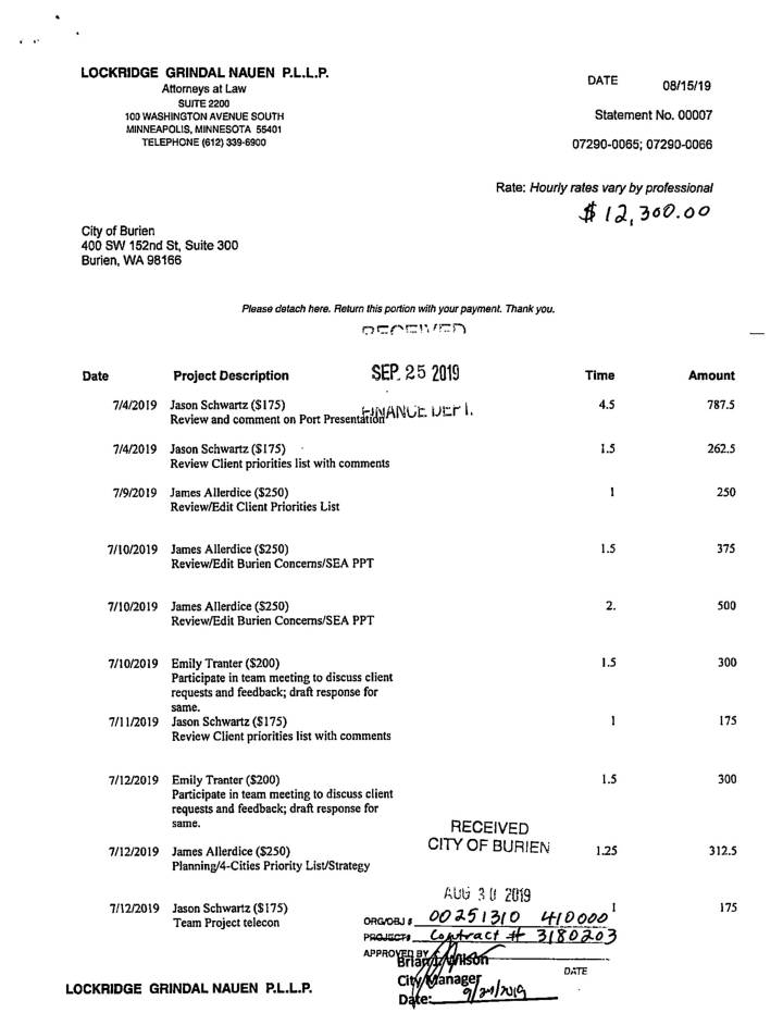
This document contains a July 2019 legal billing statement from Lockridge Grindal Nauen P.L.L.P. to the City of Burien for $12,300, covering attorney work related to the Sea-Tac Airport Sustainable Airport Master Plan (SAMP) environmental review. The work included reviewing airspace modeling reports, Port presentations, and client priority lists. The billing is part of a broader Interlocal Agreement among Burien, Des Moines, Normandy Park, and SeaTac, with costs shared among the four cities based on population, under a total $175,000 contract. -
 2019-08-15
Lockridge Grindal Nauen PLLP Invoice No. 7: City of Burien SAMP Legal Services, July 2019
This document contains a July 2019 legal billing statement from Lockridge Grindal Nauen P.L.L.P. to the City of Burien for $12,300, covering attorney work related to the Sea-Tac Airport Sustainable Airport Master Plan (SAMP) environmental review. The work included reviewing airspace modeling reports, Port presentations, and client priority lists. The billing is part of a broader Interlocal Agreement among Burien, Des Moines, Normandy Park, and SeaTac, with costs shared among the four cities based on population, under a total $175,000 contract. -
 2019-08-15
Billing Backup for City Shares of Lockridge Grindal Nauen Invoices for Sea-Tac Airport SAMP Review
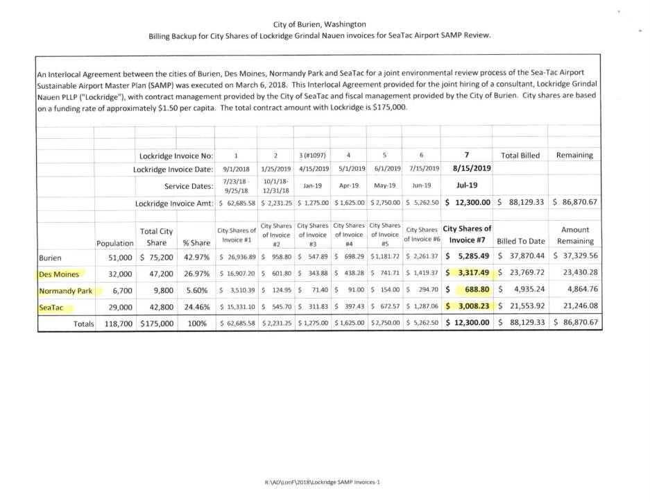
This document details billing records from the City of Burien, Washington, for legal consulting services provided by Lockridge Grindal Nauen PLLP related to the Sea-Tac Airport Sustainable Airport Master Plan (SAMP) environmental review. Four cities — Burien, Des Moines, Normandy Park, and SeaTac — shared consulting costs based on population, with a total contract value of $175,000 funded at approximately $1.50 per capita. Invoice #7, dated August 15, 2019, covered $12,300 in July 2019 legal work including review of airport airspace modeling reports and client priority documents. -
 2019-08-15
Billing Backup for City Shares of Lockridge Grindal Nauen Invoices for Sea-Tac Airport SAMP Review
This document details billing records from the City of Burien, Washington, for legal consulting services provided by Lockridge Grindal Nauen PLLP related to the Sea-Tac Airport Sustainable Airport Master Plan (SAMP) environmental review. Four cities — Burien, Des Moines, Normandy Park, and SeaTac — shared consulting costs based on population, with a total contract value of $175,000 funded at approximately $1.50 per capita. Invoice #7, dated August 15, 2019, covered $12,300 in July 2019 legal work including review of airport airspace modeling reports and client priority documents. -
 2019-08-15
Billing Backup for City Shares of Lockridge Grindal Nauen Invoices for Sea-Tac Airport SAMP Review
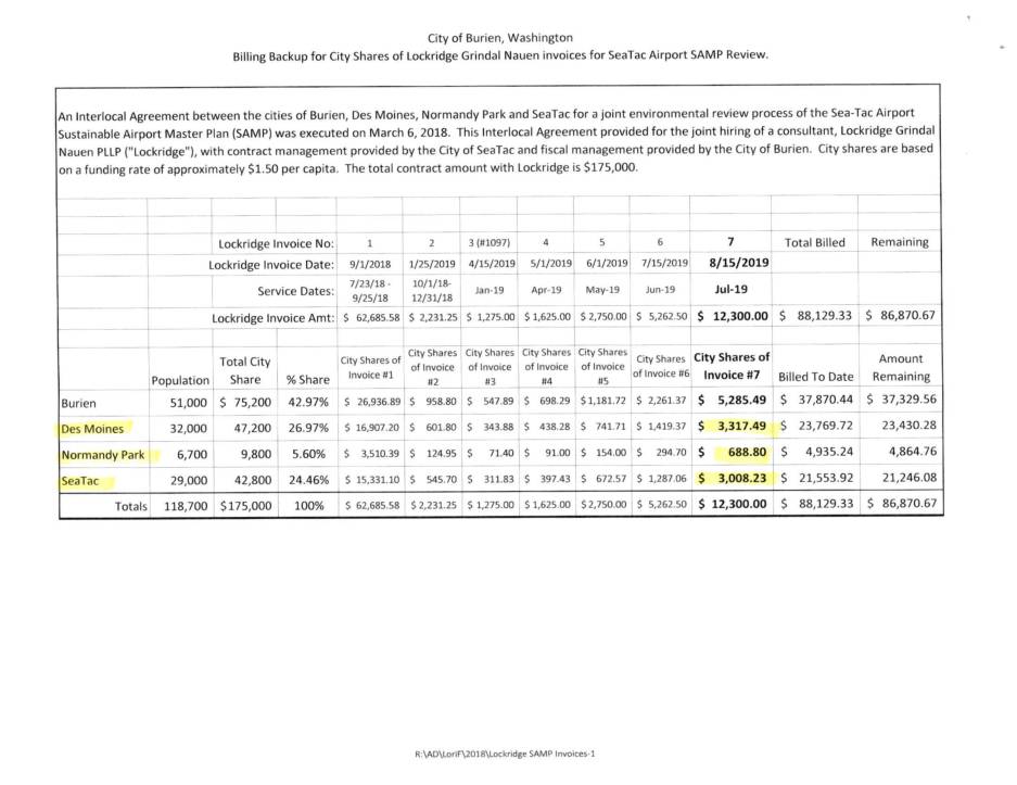
This document details billing records from Lockridge Grindal Nauen P.L.L.P., a law firm hired jointly by the cities of Burien, Des Moines, Normandy Park, and SeaTac to review the Sea-Tac Airport Sustainable Airport Master Plan (SAMP). Under an Interlocal Agreement executed in March 2018, each city's share of the $175,000 total contract was calculated based on population at approximately $1.50 per capita. Invoice #7, dated August 15, 2019, covers legal services performed in July 2019 totaling $12,300, which included reviewing airspace modeling reports, analyzing client priorities, and preparing feedback on Port presentations. -
 2019-08-15
Billing Backup for City Shares of Lockridge Grindal Nauen Invoices for Sea-Tac Airport SAMP Review
This document details billing records from Lockridge Grindal Nauen P.L.L.P., a law firm hired jointly by the cities of Burien, Des Moines, Normandy Park, and SeaTac to review the Sea-Tac Airport Sustainable Airport Master Plan (SAMP). Under an Interlocal Agreement executed in March 2018, each city's share of the $175,000 total contract was calculated based on population at approximately $1.50 per capita. Invoice #7, dated August 15, 2019, covers legal services performed in July 2019 totaling $12,300, which included reviewing airspace modeling reports, analyzing client priorities, and preparing feedback on Port presentations. -
 2019-08-13
City of Des Moines Letter to Lance Lyttle Suspending StART Participation
In August 2019, the City of Des Moines formally notified Sea-Tac Airport's Director of Aviation that it was suspending its participation in the Stakeholder Advisory Roundtable (StART) Committee. The decision followed the Port of Seattle's approval of $10 million for Near-Term Airport Master Plan design work at an off-site meeting held without prior notice to affected communities, which Des Moines argued violated state environmental review requirements and broke the trust the StART process was built upon. The letter also highlights ongoing concerns about the disproportionate noise and health impacts experienced by Des Moines residents due to the city's proximity to Sea-Tac Airport. -
2019-08-13
City of Des Moines Letter to Lance Lyttle Suspending StART Participation
In August 2019, the City of Des Moines formally notified Sea-Tac Airport's Director of Aviation that it was suspending its participation in the Stakeholder Advisory Roundtable (StART) Committee. The decision followed the Port of Seattle's approval of $10 million for Near-Term Airport Master Plan design work at an off-site meeting held without prior notice to affected communities, which Des Moines argued violated state environmental review requirements and broke the trust the StART process was built upon. The letter also highlights ongoing concerns about the disproportionate noise and health impacts experienced by Des Moines residents due to the city's proximity to Sea-Tac Airport.