The new technology steers air traffic on autopilot along a smoothly descending, satellite-guided path, avoiding the stair-step approach and constant interplay with air traffic controllers now required to bring in planes.

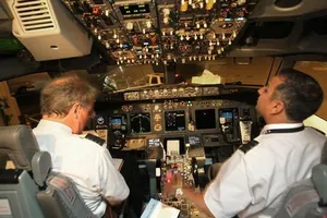
On a clear mid-August night at about 3 a.m., an Alaska Airlines 737 heading to Seattle-Tacoma International Airport took a radical turn.
Jets typically begin their approach to Sea-Tac as many as 20 miles north of the runway and fly south over Seattle’s residential neighborhoods, roughly following Interstate 5 from Edmonds down through Northgate, Lake City, Green Lake, Ravenna, the U District and the Central District.
But on this test flight, Alaska Airlines was demonstrating a new satellite-based airplane navigation system that it hopes will transform air-traffic patterns at Sea-Tac.
So the jet made its turn over Elliott Bay instead, and lined up with Sea-Tac’s runway lights near Qwest Field, just six miles north of the airport.
The new technology steers air traffic on autopilot along a smoothly descending, satellite-guided path, avoiding the stair-step approach and constant interplay with air traffic controllers now required to bring in planes.
It promises to save airlines big money on fuel while cutting overflights, noise, and carbon emissions for people on the ground. Based on experience where it’s been deployed, the system should be safer and reduce delays for travelers.
Alaska Airlines, supported by Boeing’s Jeppesen navigation unit, hopes to use Sea-Tac as a template for the FAA’s planned revamp of the entire country’s air-transportation network.
“This is a perfect place to do this,” said Mike Adams, the pilot in command of the August test flight. “Boeing is here. Alaska has a completely equipped fleet. Everybody is trained. We are so ready, we can’t stand it any more.”
Alaska projects reduced overflight noise for 750,000 Seattle-area residents, along with annual savings at the airport of 2.1 million gallons of fuel and 25,000 tons of carbon-dioxide emissions.
“There is nobody who loses here,” Adams said.
Getting to the promised future involves a highly complex transition, however, and federal regulators and airlines have been slow to move forward.
If Sea-Tac does emerge as a model for this aspect of the FAA’s Next Generation (or NextGen) project, it will be largely due to the pioneering work of Alaska Airlines.
The airline began using the new navigation system in 1996 to enable its planes to fly safely into Juneau, Alaska, approaching along a narrow sea channel surrounded by rugged mountains. Other airlines have since applied it in other areas, including Australia and Tibet.
The technology, which links satellite-based GPS with the plane’s autopilot system, has proved its accuracy in such difficult terrain. A plane can be steered along an aerial highway not much wider than its wingspan, with another plane spaced precisely behind it.
Oscar Vela, co-pilot on the test flight, said introducing the system at regular U.S. airports would improve efficiency in an air-traffic system on the verge of overload.
And for the airlines, the investment now makes sense because of fuel costs and the pressure to reduce the carbon footprint of aviation.
“Now the mountains are all proverbial mountains: fuel savings and lower emissions,” Vela said.
How it works
Here’s how the system, formally called Performance-Based Navigation, works:
Currently, air traffic controllers tell pilots over the radio what direction and altitude they should take, guiding them from one ground-based way-point to another.
On the new system, using GPS-tracking satellites linked to advanced avionics on the aircraft, an airplane can be preprogrammed to fly an extremely precise pathway through the sky.
Each satellite-guided path typically follows a route that any airplane might fly without using instruments, in good visibility, and with no other traffic.
With the satellite-based system, pilots can fly these routes more accurately in darkness or bad weather and with other traffic nearby.
In addition, the landing approach can be designed so that the airplane descends gradually to the runway, rather than in the stair-step pattern typical today.
The step pattern is necessary now to keep airplanes separated. Planes must maintain one altitude until granted permission by a controller to descend to the next level. The pattern wastes fuel because to stay level, the engines must generate thrust.
The precision of the satellite-guided path allows a plane to take a more direct approach without fear of interfering with other traffic. Descending smoothly allows a virtual glide with the engines at idle, which means they are quieter and not consuming fuel.
Aboard the Alaska Airlines test flight, John Hickey, an FAA deputy administrator for aviation safety, marveled at navigating such a precise, curved approach on autopilot.
“The interaction with air traffic control was minimal,” Hickey said. “It is very, very impressive.”
With the new system, air traffic controllers should have a less hectic job, mostly monitoring traffic and giving minimal directions to planes that are much further out. In an emergency, controllers can always revert to the old system.
Two companies specialize in developing these GPS-based NextGen landing procedures: Boeing’s navigation subsidiary, Jeppesen, and Kent-based Naverus, founded by two Alaska Airline pilots who in the 1990s developed the procedures for the airline at its airports in Alaska.
The Sea-Tac procedures were designed by Jeff Witt, a former US Airways 737 pilot who now works in Jeppesen’s Atlanta office, with input from Alaska’s pilots and air traffic controllers.
As the test flight moved smoothly along the routes he had plotted on a computer, the boyish-faced 32-year-old basked in the success.
“This was all me,” Witt said.
Per Norén, the director of Boeing’s aviation infrastructure and air-traffic management unit, said onboard the test flight that if the efforts at Sea-Tac work out, “we can copy what we do here elsewhere in the U.S.”
Merging air traffic
The hard part of the Sea-Tac project lies ahead, however.
The test flight, one of a series Alaska Airlines is making at the airport this summer, was flown between midnight and 4 a.m. so there would be almost no other air traffic around.
The challenge ahead is to transition the whole air traffic control system so planes can fly such routes in the normal Sea-Tac traffic, among many planes not equipped to use the new satellite navigation.
“Drawing a path in space is one thing,” said Ken Shapero, director of marketing at Naverus. “Integrating it into the traffic flow is another.”
In Australia, where Naverus helped aviation authorities introduce the new system at the Brisbane airport beginning in 2006, it was used in more than 15,000 landings and departures during the first year.
In the U.S., implementation has been slower.
A report by the Inspector General (IG) of the Department of Transportation last month was sharply critical of FAA progress so far.
At the world’s busiest airport, Hartsfield-Jackson in Atlanta, the FAA introduced 10 advanced satellite-based landing paths two years ago. But because air-traffic policies governing planes landing on parallel runways have not been updated after a lengthy review lasting more than four years, so far not a single airline has been cleared to fly any of the routes.
At other airports, the FAA has developed landing procedures that are mere overlays of routes already flown routinely, with “little or no added benefits” such as shorter routes to provide an incentive for airlines to use them.
More broadly, according to the IG report, the “FAA has not developed a plan to effectively manage and budget for the elements necessary to deliver [the new navigation system’s] benefits,” including training for air traffic controllers and deployment of software.
The FAA’s Hickey, onboard the test flight, said it’s too early to estimate when the agency might approve Alaska Airlines’ Sea-Tac procedures for use by all airlines.
“NextGen is a long, long process of transformation from the current system to a future system that is far more efficient,” Hickey said. “It’s not a big bang. It’s going to be a bunch of incremental approaches.”
The NextGen plan stretches through 2025. Hickey said the Obama administration is looking at accelerating parts of it.
Meanwhile, Alaska Airlines officials are keen to push the envelope. “I would love Sea-Tac to be the model,” said Gary Beck, Alaska’s vice president of flight operations.
All his planes are already equipped with the necessary avionics. Southwest Airlines, the second-largest carrier at Sea-Tac, is retrofitting its fleet of almost 550 airplanes and will train its crews to be ready to use the system in 2013, by which time fully 80 percent of the planes landing at Sea-Tac will be ready.
Implementing the NextGen technology on a broad scale at the airport will require the FAA to solve the colossal puzzle of safely integrating the new system with the current one.
In the cockpit after the landing of the August test flight, Adams spoke as an ardent evangelist.
“I think you could see us doing this with passengers in late-night arrivals in one or two years,” he said. “And in daytime mainstream arrivals, potentially within five years.”