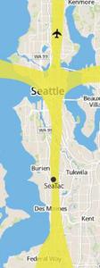
A map of the Seattle–Tacoma metropolitan area showing the Sea-Tac International Airport (labeled 'SeaTac') and a prominent yellow corridor indicating the primary flight path or noise impact zone extending northward through Seattle toward a departure/arrival route near Kenmore. Surrounding communities including Burien, Des Moines, Tukwila, and Beacon Hill are visible, consistent with materials used in airport noise-policy documentation.Open full document
Notes
A map of the Seattle–Tacoma metropolitan area showing the Sea-Tac International Airport (labeled ‘SeaTac’) and a prominent yellow corridor indicating the primary flight path or noise impact zone extending northward through Seattle toward a departure/arrival route near Kenmore. Surrounding communities including Burien, Des Moines, Tukwila, and Beacon Hill are visible, consistent with materials used in airport noise-policy documentation.