Tagproperty(41)
-
 2019-03-30 21:05
Elcon Corporation
Property Total Parcel Size Expiration Date Renewal Options Lease # Square Footage #001351 6,420 sq. ft. Indefinite Month-to-Month Elcon Corporation Building ID Code/ Common Name Function Building Owned By Total Leased Foot Print Office Whse. Sq. ft. Sq. ft. Sq. ft. Tenant Tenant Lease Information Elcon Corporation Building Information 2421 S 192nd Street SeaTac, WA 98148 Tenant General Information Current Use: Non-Aero Office Ground Lease Location: South of the Airfield (Outside the Fence City: SeaTac Page 112 Restrictions of Use—Based on Funding Bonds Airport Improvement Project Fund (AIP) Please Call for Details Please Call for Details King County Parcel #’s #2823049016 Before modifying use of property assess bonds restrictions by contacting Corporate Finance & Budget. Access AIP’s by contacting Airport Finance & Budget. Elcon Corporation Lease #001351 Transit Operations Center Elcon Corporation 28th Ave S Clean EnergyFuels Corporation Aerial Photo Taken Spring 2012 So ut h of A ir fi el d 100 20050 Feet inch = 100 feet Zone Matchline Boundary Port of Seattle Lease Boundary Page 113Date Published: 12-31-2014Disclaimer: This map is for general reference only. Data Layers that appear on this map may or may not be accurate, current, or otherwise reliable. THIS MAP IS NOT TO BE USED FOR NAVIGATION. PCS Yard Neighborhood Field Office S 1 th/ 196 Sth St . Construction Parking and Logistics -
 2019-03-30 21:05
Doug Fox Parking ATZ
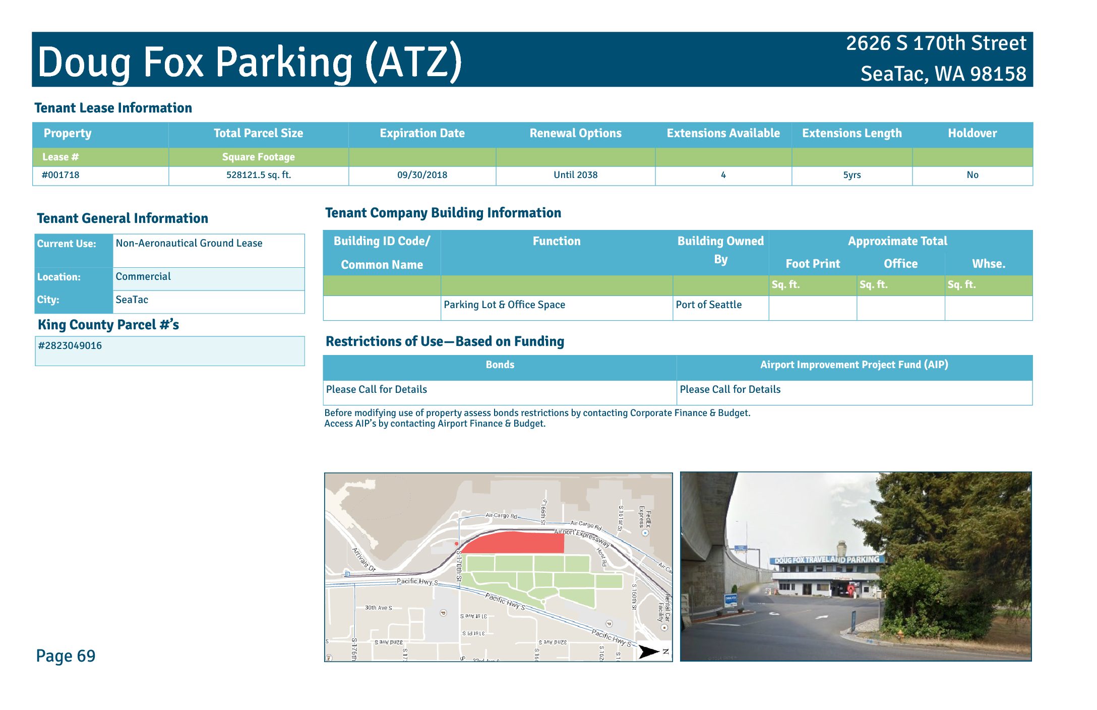
Property Total Parcel Size Expiration Date Renewal Options Extensions Available Extensions Length Holdover Lease # Square Footage #001718 528121.5 sq. ft. 09/30/2018 Until 2038 4 5yrs No Doug Fox Parking (ATZ) Building ID Code/ Common Name Function Building Owned By Approximate Total Foot Print Office Whse. Sq. ft. Sq. ft. Sq. ft. Parking Lot & Office Space Port of Seattle Tenant Lease Information Tenant Company Building Information 2626 S 170th Street SeaTac, WA 98158 Tenant General Information Current Use: Non-Aeronautical Ground Lease Location: Commercial City: SeaTac Page 69 King County Parcel #’s #2823049016 Restrictions of Use—Based on Funding Bonds Airport Improvement Project Fund (AIP) Please Call for Details Please Call for Details Before modifying use of property assess bonds restrictions by contacting Corporate Finance & Budget. Access AIP’s by contacting Airport Finance & Budget. Doug Fox Parking (ATZ) Lease #001718 Air Cargo Rd FAA Tower Doug Fox Parking (ATZ) Gate Gourmet Doug Fox Sign Co mm erc ial Ter mi na l Hardstand Cargo 6 Airport Fire Station S 1 th St Aerial Photo Taken Spring 2012 150 30075 Feet inch = 150 feet Page 70 Port of Seattle Lease Boundary C om m er ci al Date Published: 12-31-2014 Disclaimer: This map is for general reference only. Data Layers that appear on this map may or may not be accurate, current, or otherwise reliable. THIS MAP IS NOT TO BE USED FOR NAVIGATION. -
 2019-03-30 21:05
Delta-Cargo Hangar
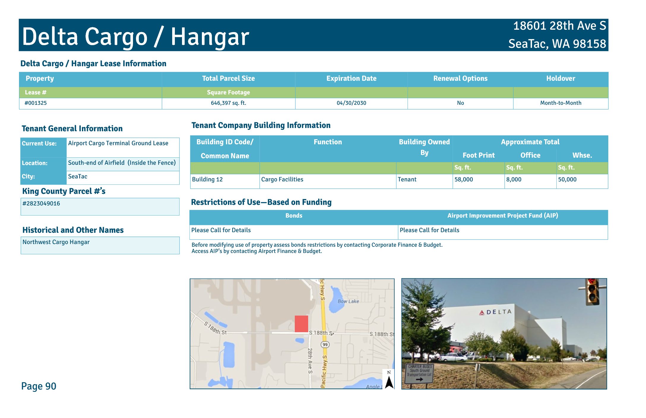
Property Total Parcel Size Expiration Date Renewal Options Holdover Lease # Square Footage #001325 646,397 sq. ft. 04/30/2030 No Month-to-Month Delta Cargo / Hangar Building ID Code/ Common Name Function Building Owned By Approximate Total Foot Print Office Whse. Sq. ft. Sq. ft. Sq. ft. Building 12 Cargo Facilities Tenant 58,000 8,000 50,000 Delta Cargo / Hangar Lease Information Tenant Company Building Information 18601 28th Ave S SeaTac, WA 98158 Tenant General Information Current Use: Airport Cargo Terminal Ground Lease Location: South-end of Airfield (Inside the Fence) City: SeaTac Page 90 Restrictions of Use—Based on Funding Bonds Airport Improvement Project Fund (AIP) Please Call for Details Please Call for Details King County Parcel #’s #2823049016 Before modifying use of property assess bonds restrictions by contacting Corporate Finance & Budget. Access AIP’s by contacting Airport Finance & Budget. Historical and Other Names Northwest Cargo Hangar Delta Cargo/Hangar Lease #001325 Ter mi na l Sou th of Air fie ld Alaska Hangar South Satellite Delta Cargo/Hangar S 1 th St SDE4 Pond Air Cargo Rd Concourse A 28th Ave S Aerial Photo Taken Spring 2012 150 30075 Feet inch = 150 feet Page 91 Port of Seattle Lease Boundary Zone Matchline Boundary Te rm in al Date Published: 12-31-2014 Disclaimer: This map is for general reference only. Data Layers that appear on this map may or may not be accurate, current, or otherwise reliable. THIS MAP IS NOT TO BE USED FOR NAVIGATION. Alaska Parking Lot -
 2019-03-30 21:05
Des Moines Creek Business Development
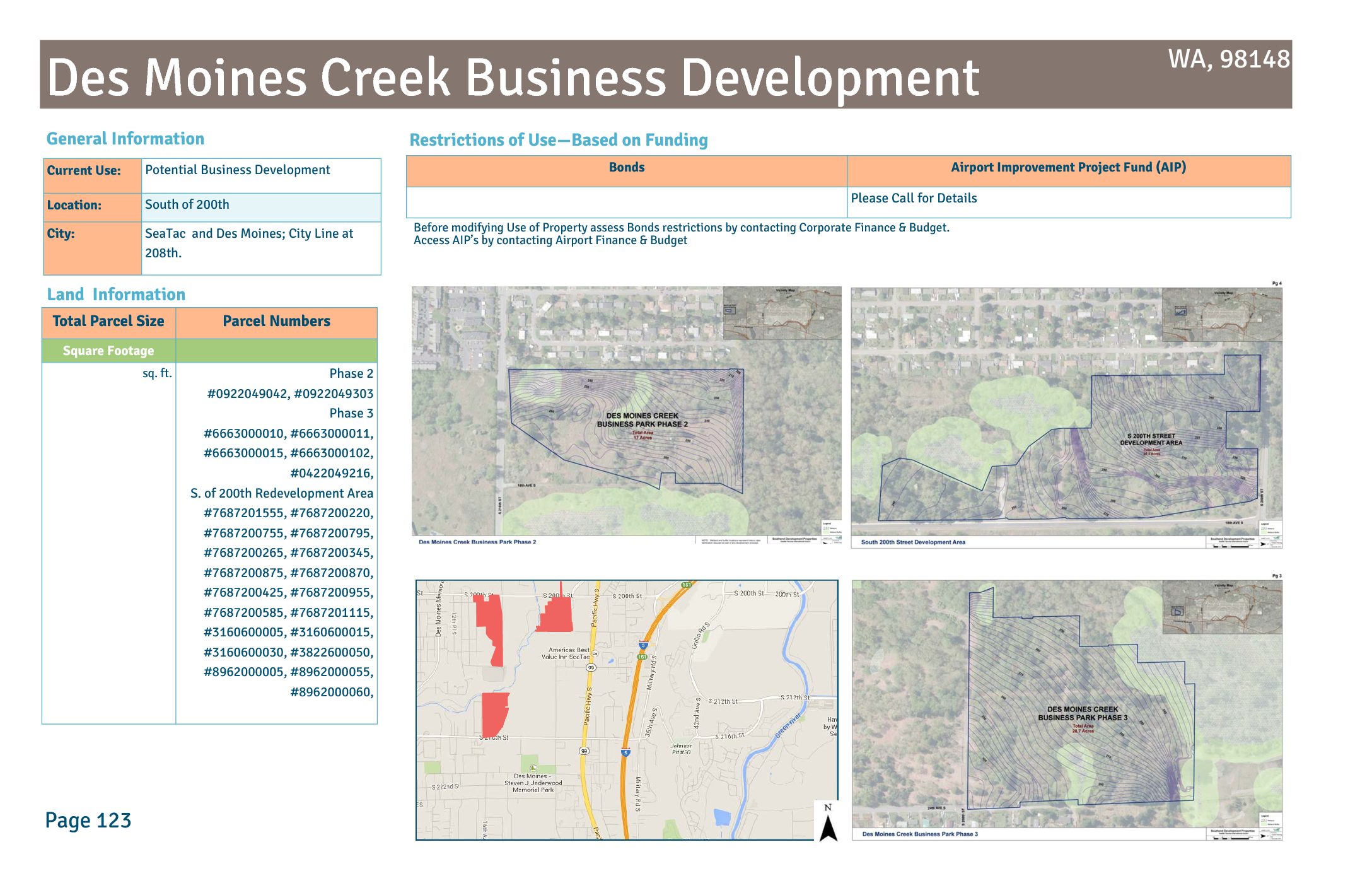
City: SeaTac and Des Moines; City Line at 208th. Page 123 Before modifying Use of Property assess Bonds restrictions by contacting Corporate Finance & Budget. Access AIP’s by contacting Airport Finance & Budget Des Moines Creek Business Development 24th Ave S S 2 16t h S t International Blvd S 2 00t h S t South 200th Street Development Area 20th Ave S 22nd Ave S S 2 08t h S t 14th Ave S S 2 04t h S t No Lease 18th Ave S Sou th of Air fie ld Panattoni Des Moines Creek Business Park Phase 3 South 5-Acre Parcel South 5-Acre 509 Parcel Des Moines Creek Business Park Phase 2 So ut h of th Aerial Photo Taken Spring 2012 500 1,000250 Feet inch = 500 feet Page 124 Non Port Property Proposed SR 509 Zone Matchline Boundary Port of Seattle Property Date Published: 12-31-2014 Disclaimer: This map is for general reference only. Data Layers that appear on this map may or may not be accurate, current, or otherwise reliable. THIS MAP IS NOT TO BE USED FOR NAVIGATION. Available For Development Sou th of Air fie ld -
 2019-03-30 21:05
Construction Parking and Logistics
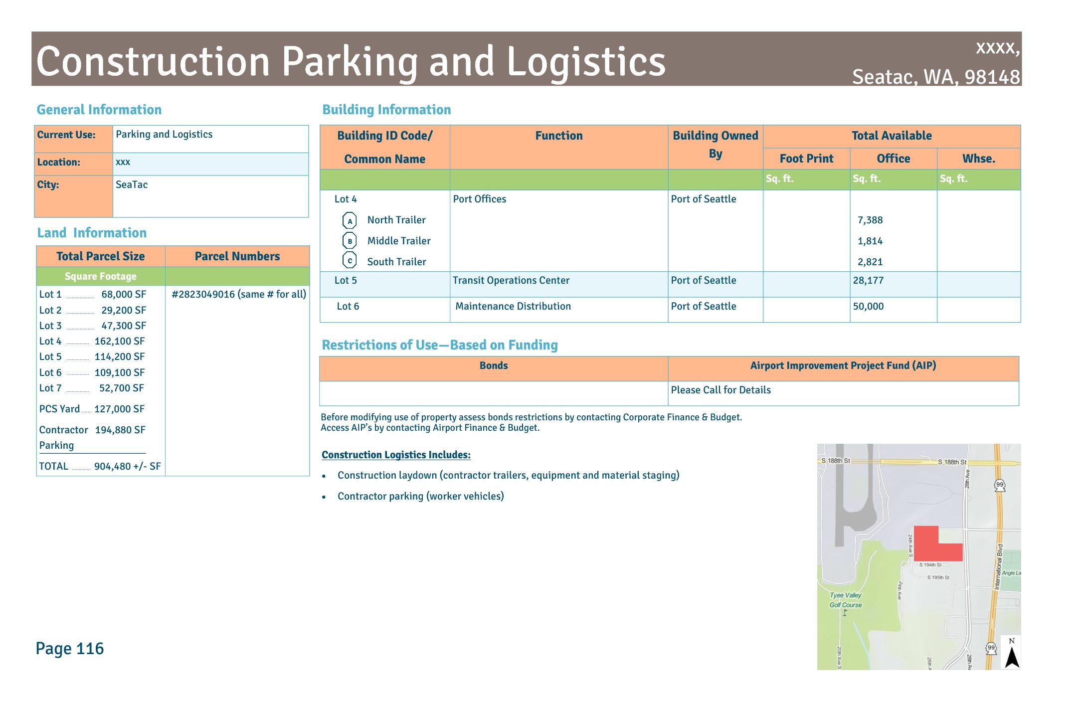
Before modifying use of property assess bonds restrictions by contacting Corporate Finance & Budget. Access AIP’s by contacting Airport Finance & Budget. Construction Logistics Includes: Construction laydown (contractor trailers, equipment and material staging) Contractor parking (worker vehicles) Building ID Code/ Common Name Function Building Owned By Total Available Foot Print Office Whse. Sq. ft. Sq. ft. Sq. ft. Lot 4 North Trailer Middle Trailer South Trailer Port Offices -
 2019-03-30 21:05
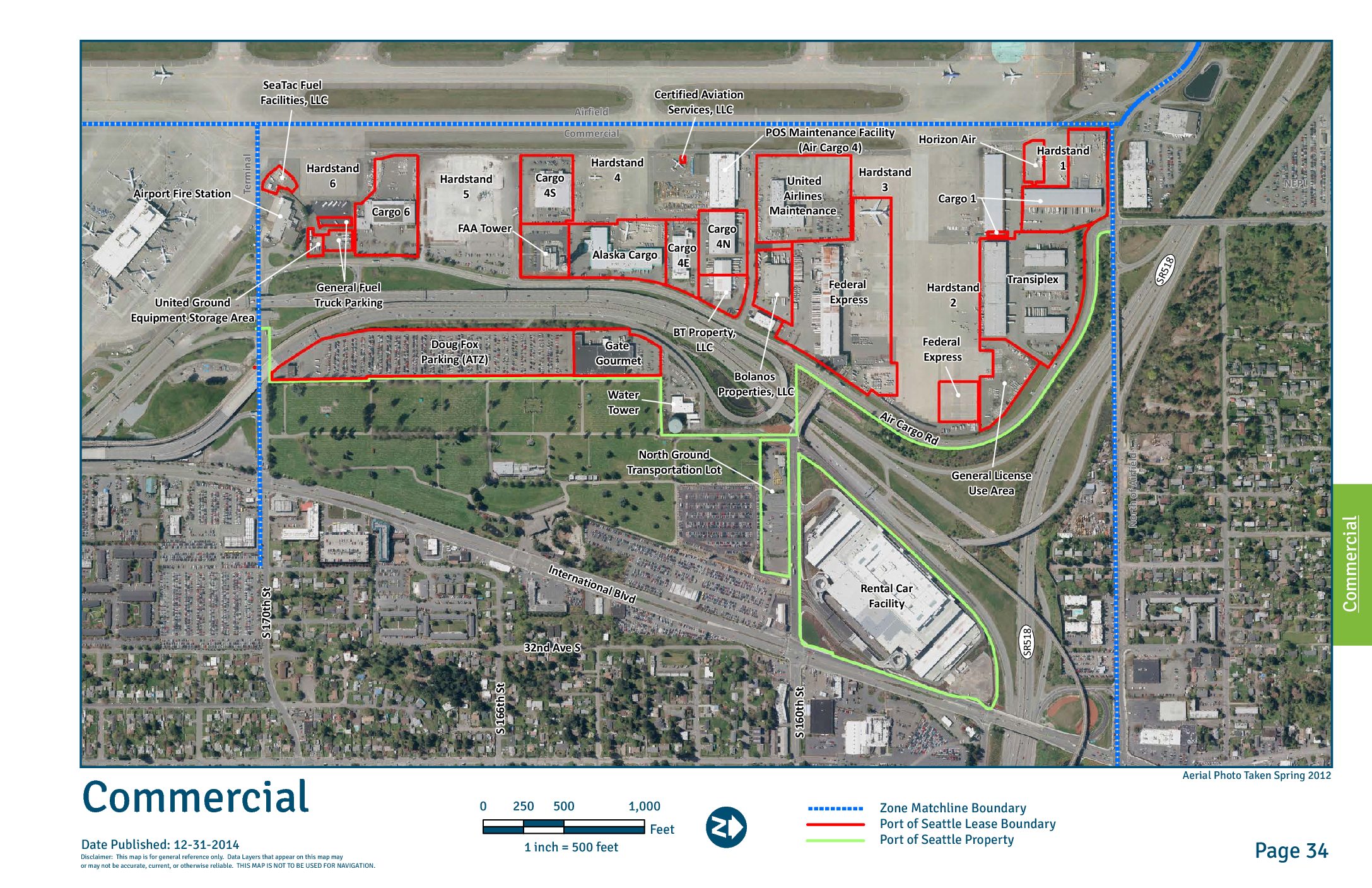
Commercial Page
Disclaimer: This map is for general reference only. Data Layers that appear on this map may or may not be accurate, current, or otherwise reliable. THIS MAP IS NOT TO BE USED FOR NAVIGATION. Cargo 4N Commercial -
 2019-03-30 21:04
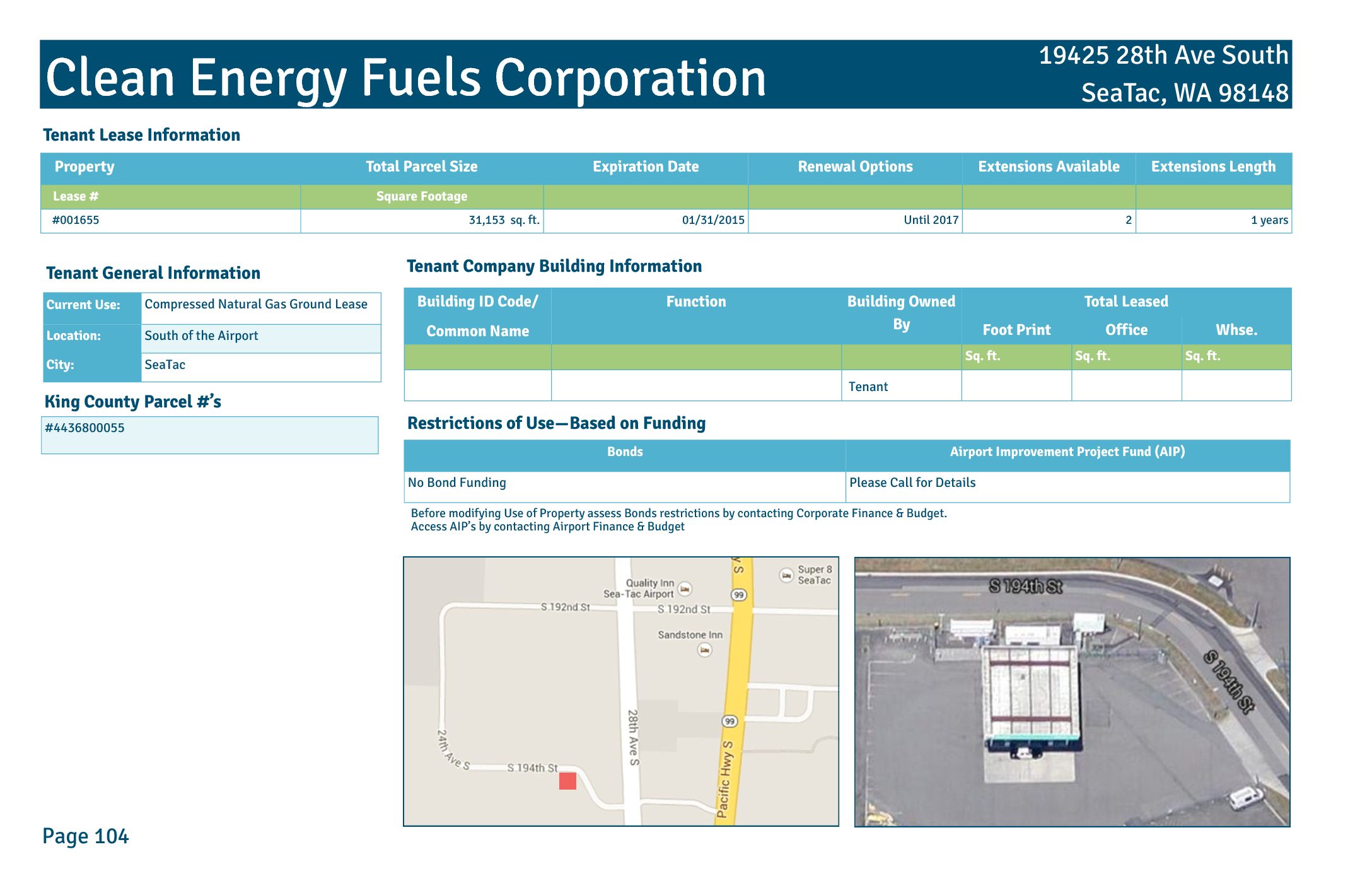
Clean Energy Fuels Corp
Property Total Parcel Size Expiration Date Renewal Options Extensions Available Extensions Length Lease # Square Footage #001655 31,153 sq. ft. 01/31/2015 Until 2017 1 years Clean Energy Fuels Corporation Building ID Code/ Common Name Function Building Owned By Total Leased Foot Print Office Whse. Sq. ft. Sq. ft. Sq. ft. Tenant Lease Information Tenant Company Building Information 19425 28th Ave South SeaTac, WA 98148 Tenant General Information Current Use: Compressed Natural Gas Ground Lease Location: South of the Airport City: SeaTac Page Restrictions of Use—Based on Funding Bonds Airport Improvement Project Fund (AIP) No Bond Funding Please Call for Details King County Parcel #’s #4436800055 Before modifying Use of Property assess Bonds restrictions by contacting Corporate Finance & Budget. Access AIP’s by contacting Airport Finance & Budget Tenant Clean Energy Fuels Corporation Lease #001655 Transit Operations Center Clean Energy Fuels Corporation 28th Ave S Elcon Corporation Aerial Photo Taken Spring 2012 So ut h of A ir fi el d 100 20050 Feet inch = 100 feet Zone Matchline Boundary Port of Seattle Lease Boundary Page 111Date Published: 12-31-2014Disclaimer: This map is for general reference only. Data Layers that appear on this map may or may not be accurate, current, or otherwise reliable. THIS MAP IS NOT TO BE USED FOR NAVIGATION. Neighborhood Field Office PCS Yard S 1 th/ 196 Sth St . Construction Parking and Logistics -
 2019-03-30 21:04
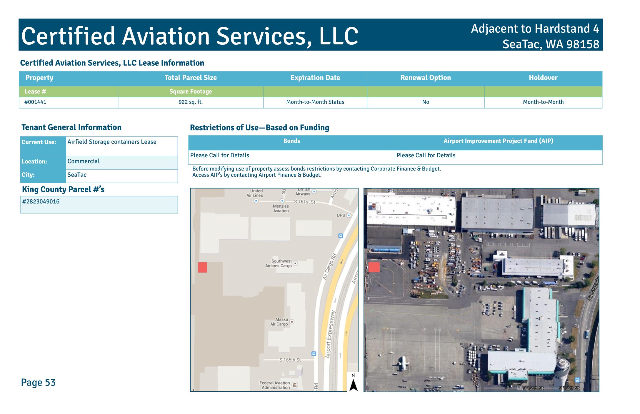
Certified Aviation Services, LLC
Property Total Parcel Size Expiration Date Holdover Renewal Option Lease # Square Footage #001441 922 sq. ft. Month-to-Month Status Month-to-Month No Certified Aviation Services, LLC Certified Aviation Services, LLC Lease Information Adjacent to Hardstand 4 SeaTac, WA 98158 Restrictions of Use—Based on Funding Bonds Airport Improvement Project Fund (AIP) Please Call for Details Please Call for Details Tenant General Information Current Use: Airfield Storage containers Lease Location: Commercial City: SeaTac Page 53 King County Parcel #’s #2823049016 Before modifying use of property assess bonds restrictions by contacting Corporate Finance & Budget. Access AIP’s by contacting Airport Finance & Budget. Certified Aviation Services, LLC Lease #001441 POS Maintenance Facility (Air Cargo 4) Certified Aviation Services, LLC Hardstand 4 C om m er ci al Aerial Photo Taken Spring 2012 10025 Feet inch = 50 feet Page 54 Port of Seattle Lease Boundary Date Published: 12-31-2014 Disclaimer: This map is for general reference only. Data Layers that appear on this map may or may not be accurate, current, or otherwise reliable. THIS MAP IS NOT TO BE USED FOR NAVIGATION. -
 2019-03-30 21:04
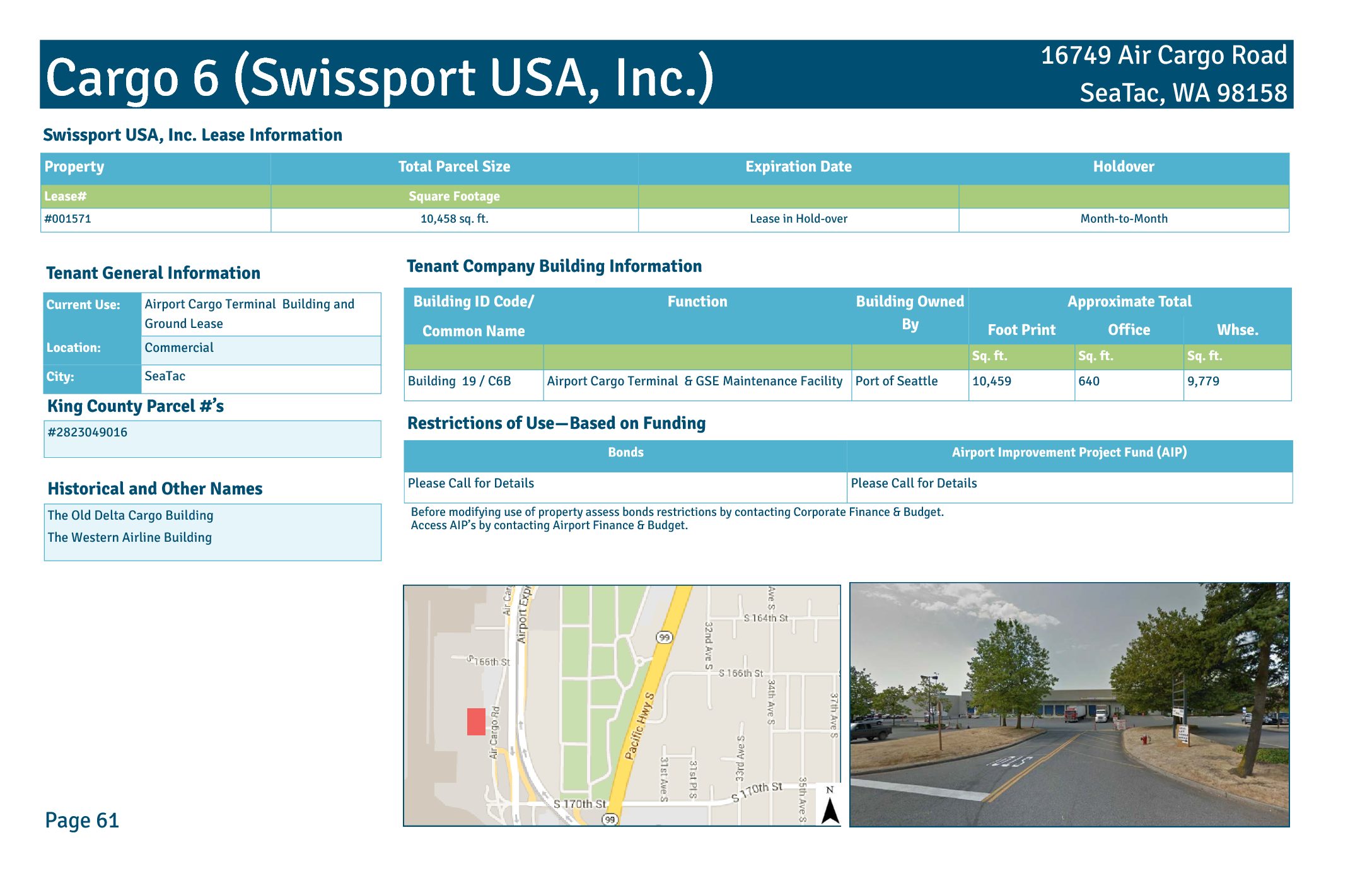
Cargo 6 Swissport USA Inc
Property Total Parcel Size Expiration Date Holdover Lease# Square Footage #001571 10,458 sq. ft. Lease in Hold-over Month-to-Month Cargo 6 (Swissport USA, Inc.) Building ID Code/ Common Name Function Building Owned By Approximate Total Foot Print Office Whse. Sq. ft. Sq. ft. Sq. ft. Building 19 / C6B Airport Cargo Terminal & GSE Maintenance Facility Port of Seattle 10,459 640 9,779 Swissport USA, Inc. Lease Information Tenant Company Building Information 16749 Air Cargo Road SeaTac, WA 98158 Tenant General Information Current Use: Airport Cargo Terminal Building and Ground Lease Location: Commercial City: SeaTac Page 61 King County Parcel #’s #2823049016 Restrictions of Use—Based on Funding Bonds Airport Improvement Project Fund (AIP) Please Call for Details Please Call for Details Before modifying use of property assess bonds restrictions by contacting Corporate Finance & Budget. Access AIP’s by contacting Airport Finance & Budget. Historical and Other Names The Old Delta Cargo Building The Western Airline Building Cargo 6 (Swissport USA, Inc.) Lease #001571 Air Cargo Rd Airport Fire Station Cargo 6 General Fuel Trucks Parking United Ground Equipment Storage Area Hardstand 5 Hardstand 6 Co m m er ci al Aerial Photo Taken Spring 2012 100 20050 Feet inch = 100 feet Page 62 Port of Seattle Lease Boundary Date Published: 12-31-2014 Disclaimer: This map is for general reference only. Data Layers that appear on this map may or may not be accurate, current, or otherwise reliable. THIS MAP IS NOT TO BE USED FOR NAVIGATION. -
 2019-03-30 21:04
Cargo4S Building
Property Total Parcel Size Expiration Date Renewal Options Extensions Available Lease # Square Footage Multiple Direct Leases 46,298 sq. ft. Determined By Individual Leases Determined By Individual Leases Determined By Individual Leases Cargo 4S Building (C4S) Building ID Code/ Common Name Function Building Owned By Approximate Total Foot Print Office Whse. Sq. ft. Sq. ft. Sq. ft. Building 16 / C4B Airport Cargo Terminal Port of Seattle 61,004 5,250 55,754 Cargo 4 Building Lease Information Tenant Company Building Information 2380 S 166th Street SeaTac, WA 98158 Tenant General Information Current Use: Port-Owned Airport Cargo Terminal Location: Commercial City: SeaTac Page 57 King County Parcel #’s #2823049016 Restrictions of Use—Based on Funding Bonds Airport Improvement Project Fund (AIP) Please Call for Details Please Call for Details Before modifying use of property assess bonds restrictions by contacting Corporate Finance & Budget. Access AIP’s by contacting Airport Finance & Budget. Historical and Other Names United Cargo Building Cargo 4S Building Multiple Leased Space Commercial Alaska Cargo FAA Tower Hardstand 5 Airfield Hardstand 4 Cargo 4S C om m er ci al Aerial Photo Taken Spring 2012 100 20050 Feet inch = 100 feet Page 58 Port of Seattle Lease Boundary Zone Matchline Boundary Date Published: 12-31-2014 Disclaimer: This map is for general reference only. Data Layers that appear on this map may or may not be accurate, current, or otherwise reliable. THIS MAP IS NOT TO BE USED FOR NAVIGATION.